Totomixtlahuaca elevation
Totomixtlahuaca (Guerrero, Tlacoapa), Mexico elevation is 858 meters and Totomixtlahuaca elevation in feet is 2815 ft above sea level [src 1]. Totomixtlahuaca is a populated place (feature code) with elevation that is 456 meters (1496 ft) smaller than average city elevation in Mexico.
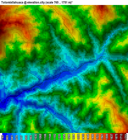
Below is the Elevation map of Totomixtlahuaca, which displays elevation range with different colors. Scale of the first map is from 765 to 1751 m (2510 to 5745 ft) with average elevation of 1130.6 meters (=3709 ft) [note 1]
These maps also provides idea of topography and contour of this city, they are displayed at different zoom levels. More info about maps, scale and edge coordinates you can find below images.
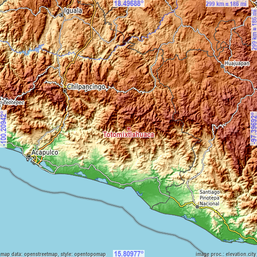
| \ | Map #1 | Topo.Map |
| Scale [m] | 765..1751 m | × |
| Scale [ft] | 2510..5745 ft | × |
| Average | 1130.6 m = 3709 ft | × |
| Width | 9.34 km = 5.8 mi | 298.8 km = 185.7 mi |
| Height | 9.34 km = 5.8 mi | 298.8 km = 185.7 mi |
| ↑Max Latitude | 17.200175° | 18.49688° |
| Latitude at center | 17.15819° | 17.15819° |
| ↓Min Latitude | 17.116196° | 15.80977° |
| ← Min Longitude | -98.847115° | -100.20942° |
| Longitude center | -98.80317° | -98.80317° |
| →Max Longitude | -98.759225° | -97.39692° |
Nearby cities:
Cities around Totomixtlahuaca sort by population:
• El Rincón (Santa Cruz del Rincón) elevation 610 m
19.4 km,  158°
158°
• Acatepec 1748 m
21.7 km,  328°
328°
• Iliatenco 1050 m
17.7 km,  135°
135°
• Tlacoapa 1411 m
13.1 km,  26°
26°
• El Potrerillo (Potrerillo del Rincón) 691 m
23.5 km, 160°
• Tlaxcalixtlahuaca 536 m
19.8 km,  172°
172°
• Pascala del Oro 1089 m
11.5 km,  183°
183°
• Malinaltepec 1522 m
17 km,  55°
55°
• Colombia de Guadalupe 1385 m
9.1 km,  148°
148°
• Paraje Montero (Paraje Montero de Zaragoza) 1988 m
10.6 km,  86°
86°
• Caxitepec 1827 m
23.1 km,  310°
310°
• Moyotepec (Moyotepec de Juárez) 2264 m
23 km, 32°
Multilingual:
 En español:
Totomixtlahuaca elevación 858 m.
 En France:
Totomixtlahuaca élévation 858 m.
 Auf Deutsch:
Totomixtlahuaca höhe über dem Meeresspiegel ist 858 m.

Sources and notes:
- [note 1] Map square and city borders are not equal. Map elevation data is calculated only from area inside that square.
- [src 1] Elevation data from geonames database provided with same terms of usage.
- [src 2] The elevation map of Totomixtlahuaca is generated using elevation data from NASA's 3 arcsec (90m) resolution SRTM data.
- [src 3] Base (background) map © OpenStreetMap contributors tiles are generated by Geofabrik and OpenTopoMap.
Copyright & License:
This Totomixtlahuaca Elevation Map is licensed under CC BY-SA. You may reuse any part from this page, if you give a proper credit by linking to this URL:
 More info on terms of use page.