Maravilla Tenejapa elevation
Maravilla Tenejapa (Chiapas), Mexico elevation is 374 meters and Maravilla Tenejapa elevation in feet is 1227 ft above sea level [src 1]. Maravilla Tenejapa is a seat of a second-order administrative division (feature code) with elevation that is 940 meters (3084 ft) smaller than average city elevation in Mexico.
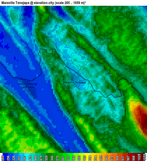
Below is the Elevation map of Maravilla Tenejapa, which displays elevation range with different colors. Scale of the first map is from 265 to 1059 m (869 to 3474 ft) with average elevation of 471.4 meters (=1547 ft) [note 1]
These maps also provides idea of topography and contour of this city, they are displayed at different zoom levels. More info about maps, scale and edge coordinates you can find below images.
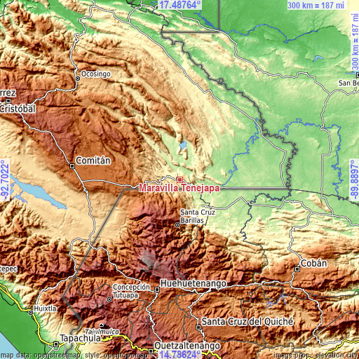
| \ | Map #1 | Topo.Map |
| Scale [m] | 265..1059 m | × |
| Scale [ft] | 869..3474 ft | × |
| Average | 471.4 m = 1547 ft | × |
| Width | 9.39 km = 5.8 mi | 300.4 km = 186.7 mi |
| Height | 9.39 km = 5.8 mi | 300.4 km = 186.7 mi |
| ↑Max Latitude | 16.183758° | 17.48764° |
| Latitude at center | 16.14155° | 16.14155° |
| ↓Min Latitude | 16.099333° | 14.78624° |
| ← Min Longitude | -91.339895° | -92.7022° |
| Longitude center | -91.29595° | -91.29595° |
| →Max Longitude | -91.252005° | -89.8897° |
Nearby cities:
Cities around Maravilla Tenejapa sort by population:
• Lázaro Cárdenas elevation 1555 m
57.5 km,  267°
267°
• El Porvenir Agrarista 1495 m
57.7 km, 272°
• Miguel Hidalgo 1522 m
51.7 km, 265°
• San Antonio Buenavista 1378 m
37.9 km, 271°
• San Quintín 220 m
30 km,  349°
349°
• Nuevo San Juan Chamula 474 m
15.8 km, 271°
• Tziscao 1505 m
40.1 km,  260°
260°
• Río Blanco 902 m
36.8 km,  281°
281°
• El Edén 1027 m
40.1 km,  294°
294°
• Santo Domingo de las Palmas 305 m
2.8 km, 258°
• Ojo de Agua 1511 m
49.4 km, 272°
• Ramón F. Balboa 230 m
38.7 km,  342°
342°
Multilingual:
 En español:
Maravilla Tenejapa elevación 374 m.
 En France:
Maravilla Tenejapa élévation 374 m.
 Auf Deutsch:
Maravilla Tenejapa höhe über dem Meeresspiegel ist 374 m.
 На русском:
Maravilla Tenejapa высота над уровнем моря 374 м
Sources and notes:
- [note 1] Map square and city borders are not equal. Map elevation data is calculated only from area inside that square.
- [src 1] Elevation data from geonames database provided with same terms of usage.
- [src 2] The elevation map of Maravilla Tenejapa is generated using elevation data from NASA's 3 arcsec (90m) resolution SRTM data.
- [src 3] Base (background) map © OpenStreetMap contributors tiles are generated by Geofabrik and OpenTopoMap.
Copyright & License:
This Maravilla Tenejapa Elevation Map is licensed under CC BY-SA. You may reuse any part from this page, if you give a proper credit by linking to this URL:
 More info on terms of use page.