Lázaro Cárdenas elevation
Lázaro Cárdenas (Chiapas, La Trinitaria), Mexico elevation is 1555 meters and Lázaro Cárdenas elevation in feet is 5102 ft above sea level [src 1]. Lázaro Cárdenas is a populated place (feature code) with elevation that is 241 meters (791 ft) bigger than average city elevation in Mexico.
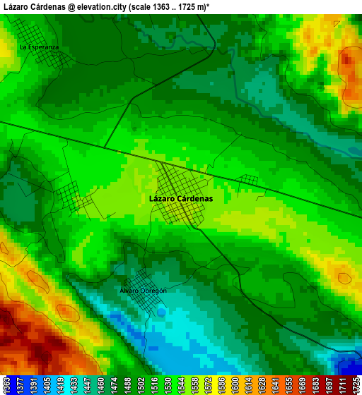
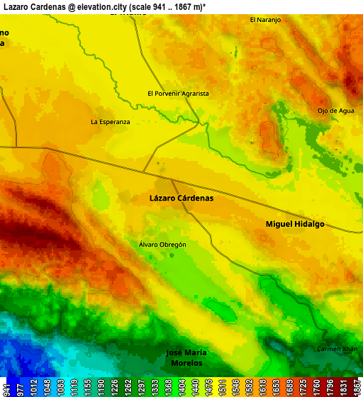
Below is the Elevation map of Lázaro Cárdenas, which displays elevation range with different colors. Scale of the first map is from 1363 to 1725 m (4472 to 5659 ft) with average elevation of 1513.3 meters (=4965 ft) [note 1]
These maps also provides idea of topography and contour of this city, they are displayed at different zoom levels. More info about maps, scale and edge coordinates you can find below images.
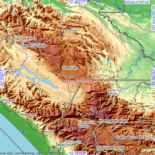
| \ | Map #1 | Map #2 | Topo.Map |
| Scale [m] | 1363..1725 m | 941..1867 m | × |
| Scale [ft] | 4472..5659 ft | 3087..6125 ft | × |
| Average | 1513.3 m = 4965 ft | 1487.6 m = 4881 ft | × |
| Width | 9.39 km = 5.8 mi | 18.78 km = 11.7 mi | 300.4 km = 186.7 mi |
| Height | 9.39 km = 5.8 mi | 18.78 km = 11.7 mi | 300.4 km = 186.7 mi |
| ↑Max Latitude | 16.158714° | 16.200918° | 17.46277° |
| Latitude at center | 16.1165° | 16.1165° | 16.1165° |
| ↓Min Latitude | 16.074277° | 16.032046° | 14.76103° |
| ← Min Longitude | -91.877465° | -91.921411° | -93.23977° |
| Longitude center | -91.83352° | -91.83352° | -91.83352° |
| →Max Longitude | -91.789575° | -91.745629° | -90.42727° |
Nearby cities:
Cities around Lázaro Cárdenas sort by population:
• El Triunfo elevation 1499 m
9.9 km,  343°
343°
• Venustiano Carranza 1516 m
13 km,  309°
309°
• José María Morelos 1294 m
8.3 km,  178°
178°
• La Esperanza 1519 m
5.4 km,  316°
316°
• El Porvenir Agrarista 1495 m
5.4 km,  357°
357°
• Miguel Hidalgo 1522 m
6.1 km,  103°
103°
• Álvaro Obregón 1453 m
2.6 km,  202°
202°
• La Patria 1501 m
15.1 km,  326°
326°
• El Progreso 1543 m
2.9 km,  268°
268°
• Santa Rita 1573 m
15.2 km,  276°
276°
• Ojo de Agua 1511 m
9.3 km,  60°
60°
• Unión Juárez 1566 m
10.7 km, 277°
Multilingual:
 En español:
Lázaro Cárdenas elevación 1555 m.
 En France:
Lázaro Cárdenas élévation 1555 m.
 Auf Deutsch:
Lázaro Cárdenas höhe über dem Meeresspiegel ist 1555 m.

Sources and notes:
- [note 1] Map square and city borders are not equal. Map elevation data is calculated only from area inside that square.
- [src 1] Elevation data from geonames database provided with same terms of usage.
- [src 2] The elevation map of Lázaro Cárdenas is generated using elevation data from NASA's 3 arcsec (90m) resolution SRTM data.
- [src 3] Base (background) map © OpenStreetMap contributors tiles are generated by Geofabrik and OpenTopoMap.
Copyright & License:
This Lázaro Cárdenas Elevation Map is licensed under CC BY-SA. You may reuse any part from this page, if you give a proper credit by linking to this URL:
 More info on terms of use page.