San Quintín elevation
San Quintín (Chiapas, Ocosingo), Mexico elevation is 220 meters and San Quintín elevation in feet is 722 ft above sea level [src 1]. San Quintín is a populated place (feature code) with elevation that is 1094 meters (3589 ft) smaller than average city elevation in Mexico.
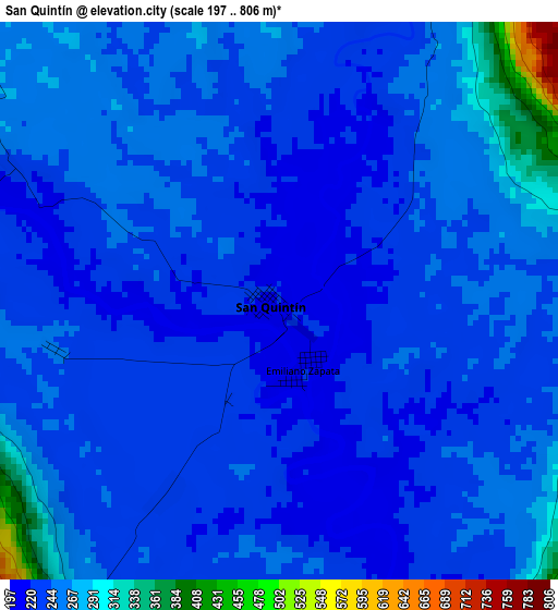
Below is the Elevation map of San Quintín, which displays elevation range with different colors. Scale of the first map is from 197 to 806 m (646 to 2644 ft) with average elevation of 246.7 meters (=809 ft) [note 1]
These maps also provides idea of topography and contour of this city, they are displayed at different zoom levels. More info about maps, scale and edge coordinates you can find below images.
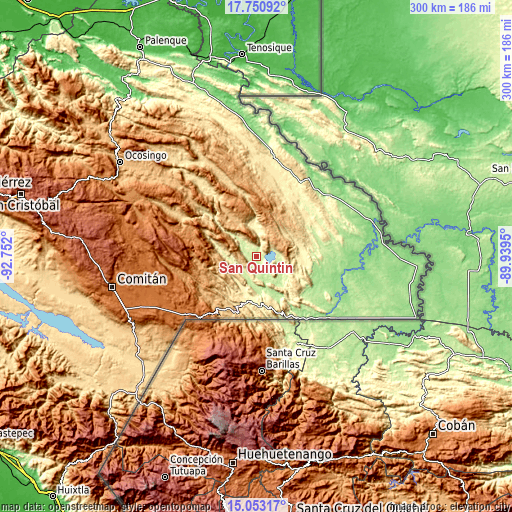
| \ | Map #1 | Topo.Map |
| Scale [m] | 197..806 m | × |
| Scale [ft] | 646..2644 ft | × |
| Average | 246.7 m = 809 ft | × |
| Width | 9.37 km = 5.8 mi | 300 km = 186.4 mi |
| Height | 9.37 km = 5.8 mi | 300 km = 186.4 mi |
| ↑Max Latitude | 16.448871° | 17.75092° |
| Latitude at center | 16.40672° | 16.40672° |
| ↓Min Latitude | 16.36456° | 15.05317° |
| ← Min Longitude | -91.389695° | -92.752° |
| Longitude center | -91.34575° | -91.34575° |
| →Max Longitude | -91.301805° | -89.9395° |
Nearby cities:
Cities around San Quintín sort by population:
• Nueva Palestina elevation 537 m
46.5 km,  11°
11°
• San Antonio Buenavista 1378 m
43.1 km,  228°
228°
• Nuevo San Juan Chamula 474 m
31 km,  199°
199°
• Perla de Acapulco 646 m
45.5 km,  341°
341°
• Maravilla Tenejapa 374 m
30 km,  169°
169°
• Río Blanco 902 m
38.1 km, 233°
• El Zapotal 630 m
39.5 km, 344°
• Las Tazas 523 m
48.4 km,  323°
323°
• El Edén 1027 m
33.6 km,  247°
247°
• Santo Domingo de las Palmas 305 m
30.1 km,  175°
175°
• Ramón F. Balboa 230 m
9.7 km, 320°
• Agua Azul 637 m
49.1 km, 337°
Multilingual:
 En español:
San Quintín elevación 220 m.
 En France:
San Quintín élévation 220 m.
 Auf Deutsch:
San Quintín höhe über dem Meeresspiegel ist 220 m.

Sources and notes:
- [note 1] Map square and city borders are not equal. Map elevation data is calculated only from area inside that square.
- [src 1] Elevation data from geonames database provided with same terms of usage.
- [src 2] The elevation map of San Quintín is generated using elevation data from NASA's 3 arcsec (90m) resolution SRTM data.
- [src 3] Base (background) map © OpenStreetMap contributors tiles are generated by Geofabrik and OpenTopoMap.
Copyright & License:
This San Quintín Elevation Map is licensed under CC BY-SA. You may reuse any part from this page, if you give a proper credit by linking to this URL:
 More info on terms of use page.