Metepec elevation
Metepec (Hidalgo), Mexico elevation is 2159 meters and Metepec elevation in feet is 7083 ft above sea level [src 1]. Metepec is a seat of a second-order administrative division (feature code) with elevation that is 845 meters (2772 ft) bigger than average city elevation in Mexico.
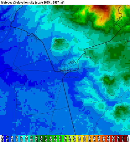
Below is the Elevation map of Metepec, which displays elevation range with different colors. Scale of the first map is from 2099 to 2597 m (6886 to 8520 ft) with average elevation of 2178.4 meters (=7147 ft) [note 1]
These maps also provides idea of topography and contour of this city, they are displayed at different zoom levels. More info about maps, scale and edge coordinates you can find below images.
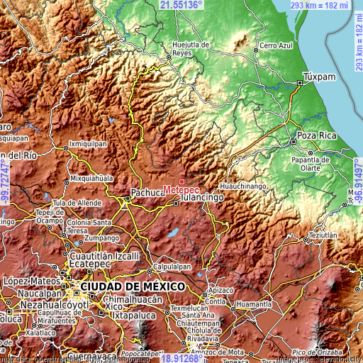
| \ | Map #1 | Topo.Map |
| Scale [m] | 2099..2597 m | × |
| Scale [ft] | 6886..8520 ft | × |
| Average | 2178.4 m = 7147 ft | × |
| Width | 9.17 km = 5.7 mi | 293.4 km = 182.3 mi |
| Height | 9.17 km = 5.7 mi | 293.4 km = 182.3 mi |
| ↑Max Latitude | 20.278847° | 21.55136° |
| Latitude at center | 20.23762° | 20.23762° |
| ↓Min Latitude | 20.196382° | 18.91268° |
| ← Min Longitude | -98.365165° | -99.72747° |
| Longitude center | -98.32122° | -98.32122° |
| →Max Longitude | -98.277275° | -96.91497° |
Nearby cities:
Cities around Metepec sort by population:
• Parque Urbano Napateco elevation 2165 m
10.7 km,  190°
190°
• Santa Ana Hueytlalpan 2161 m
7 km,  172°
172°
• Santa María Asunción 2194 m
10.6 km,  149°
149°
• San Mateo 2291 m
9.9 km,  128°
128°
• San Pedro Tlachichilco 2194 m
10.4 km, 145°
• Colonia 28 de Mayo (Santa Rosa) 2128 m
10.7 km,  222°
222°
• La Magdalena 2223 m
5.2 km,  65°
65°
• Estación de Apulco 2192 m
6 km,  333°
333°
• Chila de Juárez 1601 m
12.6 km, 67°
• Zacacuautla 2200 m
10 km,  104°
104°
• Tonalixco 2256 m
6.9 km, 95°
• Honey 2103 m
11.3 km,  89°
89°
Multilingual:
 En español:
Metepec elevación 2159 m.
 En France:
Metepec élévation 2159 m.
 Auf Deutsch:
Metepec höhe über dem Meeresspiegel ist 2159 m.

Sources and notes:
- [note 1] Map square and city borders are not equal. Map elevation data is calculated only from area inside that square.
- [src 1] Elevation data from geonames database provided with same terms of usage.
- [src 2] The elevation map of Metepec is generated using elevation data from NASA's 3 arcsec (90m) resolution SRTM data.
- [src 3] Base (background) map © OpenStreetMap contributors tiles are generated by Geofabrik and OpenTopoMap.
Copyright & License:
This Metepec Elevation Map is licensed under CC BY-SA. You may reuse any part from this page, if you give a proper credit by linking to this URL:
 More info on terms of use page.