Parque Urbano Napateco elevation
Parque Urbano Napateco (Hidalgo, Tulancingo de Bravo), Mexico elevation is 2165 meters and Parque Urbano Napateco elevation in feet is 7103 ft above sea level [src 1]. Parque Urbano Napateco is a populated place (feature code) with elevation that is 851 meters (2792 ft) bigger than average city elevation in Mexico.
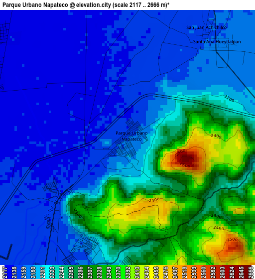
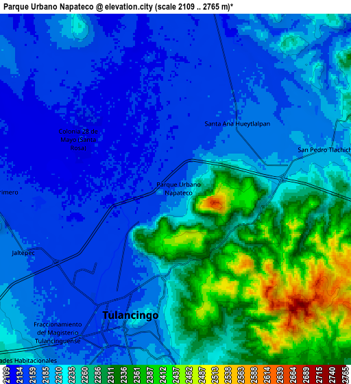
Below is the Elevation map of Parque Urbano Napateco, which displays elevation range with different colors. Scale of the first map is from 2117 to 2666 m (6946 to 8747 ft) with average elevation of 2216.8 meters (=7273 ft) [note 1]
These maps also provides idea of topography and contour of this city, they are displayed at different zoom levels. More info about maps, scale and edge coordinates you can find below images.
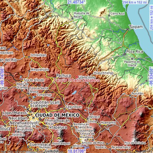
| \ | Map #1 | Map #2 | Topo.Map |
| Scale [m] | 2117..2666 m | 2109..2765 m | × |
| Scale [ft] | 6946..8747 ft | 6919..9072 ft | × |
| Average | 2216.8 m = 7273 ft | 2221.9 m = 7290 ft | × |
| Width | 9.17 km = 5.7 mi | 18.35 km = 11.4 mi | 293.6 km = 182.4 mi |
| Height | 9.17 km = 5.7 mi | 18.35 km = 11.4 mi | 293.6 km = 182.4 mi |
| ↑Max Latitude | 20.184032° | 20.225273° | 21.45734° |
| Latitude at center | 20.14278° | 20.14278° | 20.14278° |
| ↓Min Latitude | 20.101517° | 20.060243° | 18.81706° |
| ← Min Longitude | -98.384775° | -98.428721° | -99.74708° |
| Longitude center | -98.34083° | -98.34083° | -98.34083° |
| →Max Longitude | -98.296885° | -98.252939° | -96.93458° |
Nearby cities:
Cities around Parque Urbano Napateco sort by population:
• Tulancingo elevation 2187 m
7 km,  199°
199°
• Jaltepec 2164 m
8.5 km,  249°
249°
• Santa Ana Hueytlalpan 2161 m
4.7 km,  40°
40°
• Santa María Asunción 2194 m
7.5 km,  79°
79°
• Rincones de la Hacienda 2148 m
6.8 km, 248°
• San Pedro Tlachichilco 2194 m
8.3 km, 75°
• Ahuehuetitla 2180 m
10.2 km,  230°
230°
• Colonia 28 de Mayo (Santa Rosa) 2128 m
5.8 km,  296°
296°
• Fraccionamiento del Magisterio Tulancinguense 2156 m
9.6 km,  219°
219°
• Metepec Primero 2152 m
9.5 km,  269°
269°
• San Nicolás el Chico 2151 m
7.2 km, 223°
• Fraccionamiento Carlos Salinas de Gortari 2179 m
10 km, 248°
Multilingual:
 En español:
Parque Urbano Napateco elevación 2165 m.
 En France:
Parque Urbano Napateco élévation 2165 m.
 Auf Deutsch:
Parque Urbano Napateco höhe über dem Meeresspiegel ist 2165 m.
 На русском:
Parque Urbano Napateco высота над уровнем моря 2165 м
Sources and notes:
- [note 1] Map square and city borders are not equal. Map elevation data is calculated only from area inside that square.
- [src 1] Elevation data from geonames database provided with same terms of usage.
- [src 2] The elevation map of Parque Urbano Napateco is generated using elevation data from NASA's 3 arcsec (90m) resolution SRTM data.
- [src 3] Base (background) map © OpenStreetMap contributors tiles are generated by Geofabrik and OpenTopoMap.
Copyright & License:
This Parque Urbano Napateco Elevation Map is licensed under CC BY-SA. You may reuse any part from this page, if you give a proper credit by linking to this URL:
 More info on terms of use page.