Naranjos elevation
Naranjos (Veracruz, Naranjos Amatlán), Mexico elevation is 62 meters and Naranjos elevation in feet is 203 ft above sea level [src 1]. Naranjos is a seat of a second-order administrative division (feature code) with elevation that is 1252 meters (4108 ft) smaller than average city elevation in Mexico.
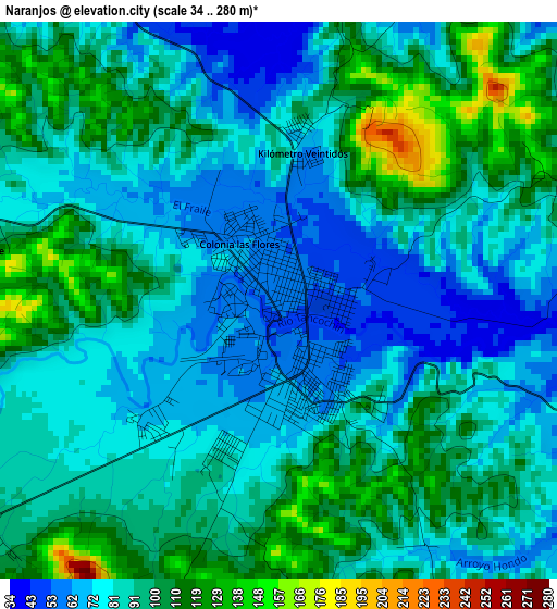
Below is the Elevation map of Naranjos, which displays elevation range with different colors. Scale of the first map is from 34 to 280 m (112 to 919 ft) with average elevation of 89.5 meters (=294 ft) [note 1]
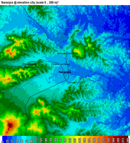
These maps also provides idea of topography and contour of this city, they are displayed at different zoom levels. More info about maps, scale and edge coordinates you can find below images.
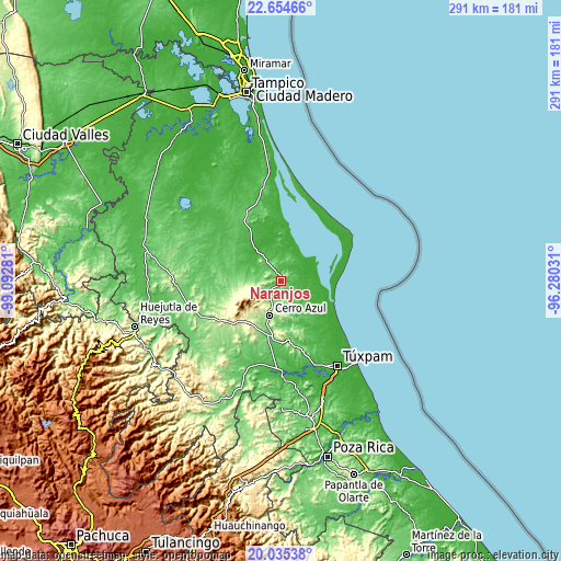
| \ | Map #1 | Map #2 | Topo.Map |
| Scale [m] | 34..280 m | 8..388 m | × |
| Scale [ft] | 112..919 ft | 26..1273 ft | × |
| Average | 89.5 m = 294 ft | 92.4 m = 303 ft | × |
| Width | 9.1 km = 5.7 mi | 18.2 km = 11.3 mi | 291.2 km = 180.9 mi |
| Height | 9.1 km = 5.7 mi | 18.2 km = 11.3 mi | 291.3 km = 181 mi |
| ↑Max Latitude | 21.391794° | 21.432706° | 22.65466° |
| Latitude at center | 21.35087° | 21.35087° | 21.35087° |
| ↓Min Latitude | 21.309935° | 21.268989° | 20.03538° |
| ← Min Longitude | -97.730505° | -97.774451° | -99.09281° |
| Longitude center | -97.68656° | -97.68656° | -97.68656° |
| →Max Longitude | -97.642615° | -97.598669° | -96.28031° |
Nearby cities:
Cities around Naranjos sort by population:
• Cerro Azul elevation 141 m
18.5 km,  197°
197°
• Chinampa de Gorostiza 106 m
5.1 km,  280°
280°
• Tamalín 147 m
13 km,  264°
264°
• Los Altos 20 m
19.1 km,  337°
337°
• Colonia las Flores 59 m
1.4 km,  330°
330°
• Amatlán 176 m
7.5 km, 256°
• Tancoco 251 m
13 km,  236°
236°
• Zacamixtle 142 m
12 km, 197°
• Tantima 199 m
15.3 km, 262°
• El Anono 178 m
11 km,  163°
163°
• Saladero 2 m
16.9 km,  61°
61°
• Gutiérrez Zamora 86 m
11.7 km, 279°
Multilingual:
 En español:
Naranjos elevación 62 m.
 En France:
Naranjos élévation 62 m.


Sources and notes:
- [note 1] Map square and city borders are not equal. Map elevation data is calculated only from area inside that square.
- [src 1] Elevation data from geonames database provided with same terms of usage.
- [src 2] The elevation map of Naranjos is generated using elevation data from NASA's 3 arcsec (90m) resolution SRTM data.
- [src 3] Base (background) map © OpenStreetMap contributors tiles are generated by Geofabrik and OpenTopoMap.
Copyright & License:
This Naranjos Elevation Map is licensed under CC BY-SA. You may reuse any part from this page, if you give a proper credit by linking to this URL:
 More info on terms of use page.