Ocotepec elevation
Ocotepec (Chiapas), Mexico elevation is 1476 meters and Ocotepec elevation in feet is 4843 ft above sea level [src 1]. Ocotepec is a seat of a second-order administrative division (feature code) with elevation that is 162 meters (531 ft) bigger than average city elevation in Mexico.
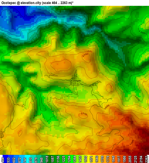
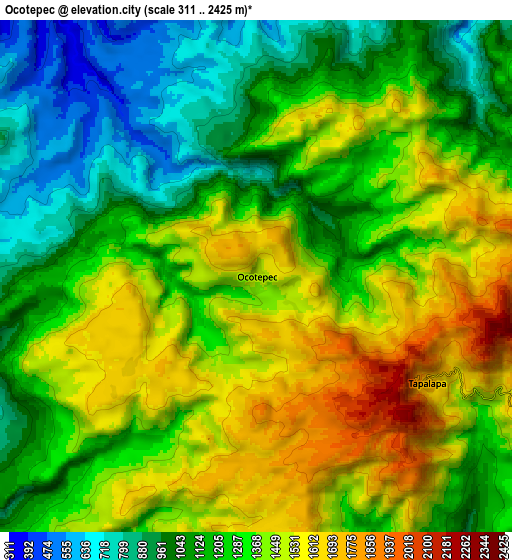
Below is the Elevation map of Ocotepec, which displays elevation range with different colors. Scale of the first map is from 464 to 2263 m (1522 to 7425 ft) with average elevation of 1404.9 meters (=4609 ft) [note 1]
These maps also provides idea of topography and contour of this city, they are displayed at different zoom levels. More info about maps, scale and edge coordinates you can find below images.
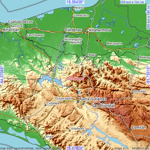
| \ | Map #1 | Map #2 | Topo.Map |
| Scale [m] | 464..2263 m | 311..2425 m | × |
| Scale [ft] | 1522..7425 ft | 1020..7956 ft | × |
| Average | 1404.9 m = 4609 ft | 1286.9 m = 4222 ft | × |
| Width | 9.33 km = 5.8 mi | 18.67 km = 11.6 mi | 298.7 km = 185.6 mi |
| Height | 9.33 km = 5.8 mi | 18.67 km = 11.6 mi | 298.7 km = 185.6 mi |
| ↑Max Latitude | 17.268169° | 17.310129° | 18.56438° |
| Latitude at center | 17.2262° | 17.2262° | 17.2262° |
| ↓Min Latitude | 17.184221° | 17.142233° | 15.87826° |
| ← Min Longitude | -93.208345° | -93.252291° | -94.57065° |
| Longitude center | -93.1644° | -93.1644° | -93.1644° |
| →Max Longitude | -93.120455° | -93.076509° | -91.75815° |
Nearby cities:
Cities around Ocotepec sort by population:
• Tapilula elevation 785 m
15.9 km,  80°
80°
• Copainalá 430 m
15.5 km,  198°
198°
• Rayón 1345 m
16.5 km,  99°
99°
• Coapilla 1639 m
10.6 km,  177°
177°
• Chapultenango 637 m
13.3 km,  15°
15°
• Tapalapa 1718 m
7.4 km,  121°
121°
• Pantepec 1477 m
12.9 km,  109°
109°
• Ángel Albino Corzo (Guadalupe) 623 m
16.2 km,  226°
226°
• San Pablo Huacano 1656 m
5.7 km, 233°
• San Francisco Jaconá 830 m
14.6 km,  73°
73°
• San Isidro las Banderas 1435 m
11.1 km,  87°
87°
• Benito Juárez 1189 m
13.1 km,  223°
223°
Multilingual:
 En español:
Ocotepec elevación 1476 m.
 En France:
Ocotepec élévation 1476 m.
 Auf Deutsch:
Ocotepec höhe über dem Meeresspiegel ist 1476 m.

Sources and notes:
- [note 1] Map square and city borders are not equal. Map elevation data is calculated only from area inside that square.
- [src 1] Elevation data from geonames database provided with same terms of usage.
- [src 2] The elevation map of Ocotepec is generated using elevation data from NASA's 3 arcsec (90m) resolution SRTM data.
- [src 3] Base (background) map © OpenStreetMap contributors tiles are generated by Geofabrik and OpenTopoMap.
Copyright & License:
This Ocotepec Elevation Map is licensed under CC BY-SA. You may reuse any part from this page, if you give a proper credit by linking to this URL:
 More info on terms of use page.