Tapilula elevation
Tapilula (Chiapas), Mexico elevation is 785 meters and Tapilula elevation in feet is 2575 ft above sea level [src 1]. Tapilula is a seat of a second-order administrative division (feature code) with elevation that is 529 meters (1736 ft) smaller than average city elevation in Mexico.
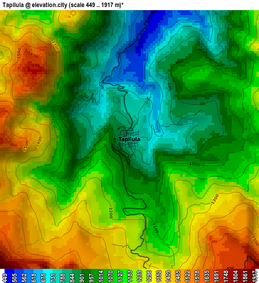
Below is the Elevation map of Tapilula, which displays elevation range with different colors. Scale of the first map is from 449 to 1917 m (1473 to 6289 ft) with average elevation of 1120.5 meters (=3676 ft) [note 1]
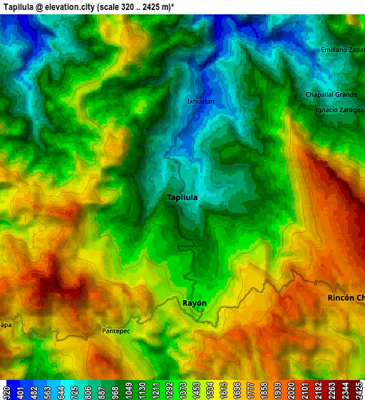
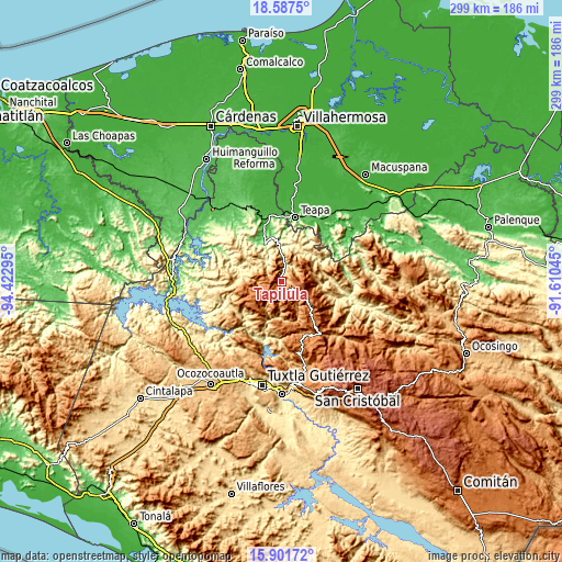
These maps also provides idea of topography and contour of this city, they are displayed at different zoom levels. More info about maps, scale and edge coordinates you can find below images.
| \ | Map #1 | Map #2 | Topo.Map |
| Scale [m] | 449..1917 m | 320..2425 m | × |
| Scale [ft] | 1473..6289 ft | 1050..7956 ft | × |
| Average | 1120.5 m = 3676 ft | 1320.2 m = 4331 ft | × |
| Width | 9.33 km = 5.8 mi | 18.67 km = 11.6 mi | 298.6 km = 185.5 mi |
| Height | 9.33 km = 5.8 mi | 18.67 km = 11.6 mi | 298.7 km = 185.6 mi |
| ↑Max Latitude | 17.291464° | 17.333418° | 18.5875° |
| Latitude at center | 17.2495° | 17.2495° | 17.2495° |
| ↓Min Latitude | 17.207526° | 17.165543° | 15.90172° |
| ← Min Longitude | -93.060645° | -93.104591° | -94.42295° |
| Longitude center | -93.0167° | -93.0167° | -93.0167° |
| →Max Longitude | -92.972755° | -92.928809° | -91.61045° |
Nearby cities:
Cities around Tapilula sort by population:
• Rayón elevation 1345 m
5.4 km,  173°
173°
• Rincón Chamula 1842 m
9.5 km,  119°
119°
• Ixhuatán 459 m
5 km,  10°
10°
• Chapultenango 637 m
15.8 km,  310°
310°
• San José Chapayal 1199 m
14.6 km,  67°
67°
• Tapalapa 1718 m
11.4 km,  235°
235°
• Pantepec 1477 m
7.7 km,  207°
207°
• San Francisco Jaconá 830 m
2.2 km, 311°
• San Isidro las Banderas 1435 m
5.1 km,  245°
245°
• Ignacio Zaragoza 889 m
9.5 km,  61°
61°
• Aurora Ermita 1508 m
15.2 km,  95°
95°
• Chapallal Grande 781 m
9.2 km, 55°
Multilingual:
 En español:
Tapilula elevación 785 m.
 En France:
Tapilula élévation 785 m.
 Auf Deutsch:
Tapilula höhe über dem Meeresspiegel ist 785 m.

Sources and notes:
- [note 1] Map square and city borders are not equal. Map elevation data is calculated only from area inside that square.
- [src 1] Elevation data from geonames database provided with same terms of usage.
- [src 2] The elevation map of Tapilula is generated using elevation data from NASA's 3 arcsec (90m) resolution SRTM data.
- [src 3] Base (background) map © OpenStreetMap contributors tiles are generated by Geofabrik and OpenTopoMap.
Copyright & License:
This Tapilula Elevation Map is licensed under CC BY-SA. You may reuse any part from this page, if you give a proper credit by linking to this URL:
 More info on terms of use page.