Rayón elevation
Rayón (Chiapas), Mexico elevation is 1345 meters and Rayón elevation in feet is 4413 ft above sea level [src 1]. Rayón is a seat of a second-order administrative division (feature code) with elevation that is 31 meters (102 ft) bigger than average city elevation in Mexico.
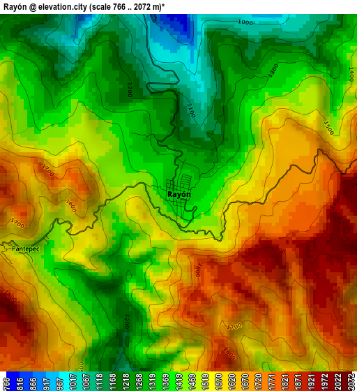
Below is the Elevation map of Rayón, which displays elevation range with different colors. Scale of the first map is from 766 to 2072 m (2513 to 6798 ft) with average elevation of 1484.8 meters (=4871 ft) [note 1]
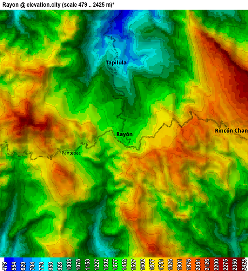
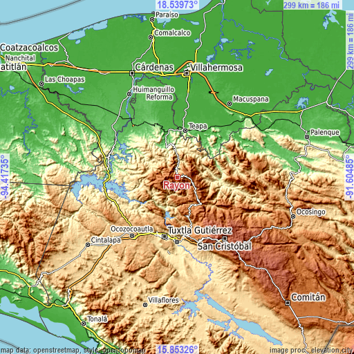
These maps also provides idea of topography and contour of this city, they are displayed at different zoom levels. More info about maps, scale and edge coordinates you can find below images.
| \ | Map #1 | Map #2 | Topo.Map |
| Scale [m] | 766..2072 m | 479..2425 m | × |
| Scale [ft] | 2513..6798 ft | 1572..7956 ft | × |
| Average | 1484.8 m = 4871 ft | 1455.9 m = 4777 ft | × |
| Width | 9.34 km = 5.8 mi | 18.67 km = 11.6 mi | 298.7 km = 185.6 mi |
| Height | 9.34 km = 5.8 mi | 18.67 km = 11.6 mi | 298.7 km = 185.6 mi |
| ↑Max Latitude | 17.243345° | 17.28531° | 18.53973° |
| Latitude at center | 17.20137° | 17.20137° | 17.20137° |
| ↓Min Latitude | 17.159386° | 17.117392° | 15.85326° |
| ← Min Longitude | -93.055045° | -93.098991° | -94.41735° |
| Longitude center | -93.0111° | -93.0111° | -93.0111° |
| →Max Longitude | -92.967155° | -92.923209° | -91.60485° |
Nearby cities:
Cities around Rayón sort by population:
• Pueblo Nuevo elevation 1727 m
12.7 km,  111°
111°
• Tapilula 785 m
5.4 km,  353°
353°
• Rincón Chamula 1842 m
7.7 km,  85°
85°
• Ixhuatán 459 m
10.2 km,  1°
1°
• Tapalapa 1718 m
10.1 km,  263°
263°
• Pantepec 1477 m
4.4 km,  250°
250°
• San Francisco Jaconá 830 m
7.2 km,  341°
341°
• San Isidro las Banderas 1435 m
6.1 km,  301°
301°
• Ignacio Zaragoza 889 m
12.5 km,  38°
38°
• Buenavista (Matasanos) 1421 m
12 km,  209°
209°
• Arroyo Grande 1758 m
14.8 km, 94°
• Chapallal Grande 781 m
12.7 km,  33°
33°
Multilingual:
 En español:
Rayón elevación 1345 m.
 En France:
Rayón élévation 1345 m.


Sources and notes:
- [note 1] Map square and city borders are not equal. Map elevation data is calculated only from area inside that square.
- [src 1] Elevation data from geonames database provided with same terms of usage.
- [src 2] The elevation map of Rayón is generated using elevation data from NASA's 3 arcsec (90m) resolution SRTM data.
- [src 3] Base (background) map © OpenStreetMap contributors tiles are generated by Geofabrik and OpenTopoMap.
Copyright & License:
This Rayón Elevation Map is licensed under CC BY-SA. You may reuse any part from this page, if you give a proper credit by linking to this URL:
 More info on terms of use page.