San Francisco Ocotlán elevation
San Francisco Ocotlán (Puebla, Coronango), Mexico elevation is 2189 meters and San Francisco Ocotlán elevation in feet is 7182 ft above sea level [src 1]. San Francisco Ocotlán is a populated place (feature code) with elevation that is 875 meters (2871 ft) bigger than average city elevation in Mexico.
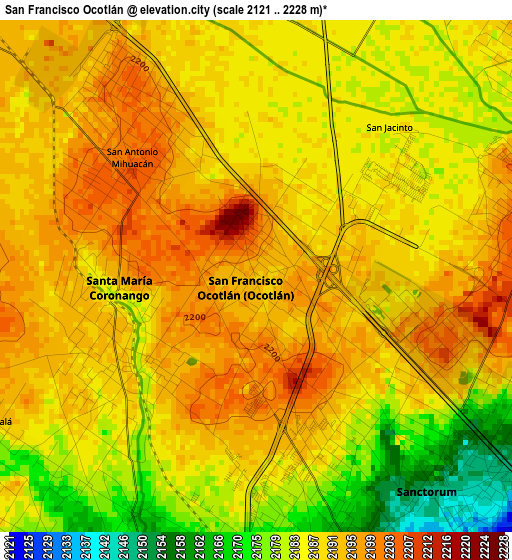
Below is the Elevation map of San Francisco Ocotlán, which displays elevation range with different colors. Scale of the first map is from 2121 to 2228 m (6959 to 7310 ft) with average elevation of 2187.8 meters (=7178 ft) [note 1]
These maps also provides idea of topography and contour of this city, they are displayed at different zoom levels. More info about maps, scale and edge coordinates you can find below images.
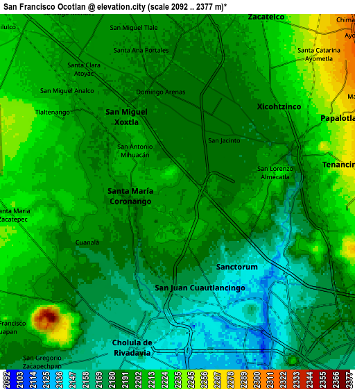
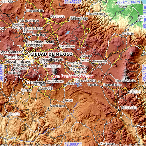
| \ | Map #1 | Map #2 | Topo.Map |
| Scale [m] | 2121..2228 m | 2092..2377 m | × |
| Scale [ft] | 6959..7310 ft | 6864..7799 ft | × |
| Average | 2187.8 m = 7178 ft | 2193.5 m = 7197 ft | × |
| Width | 9.23 km = 5.7 mi | 18.47 km = 11.5 mi | 295.4 km = 183.6 mi |
| Height | 9.23 km = 5.7 mi | 18.47 km = 11.5 mi | 295.4 km = 183.6 mi |
| ↑Max Latitude | 19.175622° | 19.217124° | 20.45722° |
| Latitude at center | 19.13411° | 19.13411° | 19.13411° |
| ↓Min Latitude | 19.092587° | 19.051054° | 17.80031° |
| ← Min Longitude | -98.327395° | -98.371341° | -99.6897° |
| Longitude center | -98.28345° | -98.28345° | -98.28345° |
| →Max Longitude | -98.239505° | -98.195559° | -96.8772° |
Nearby cities:
Cities around San Francisco Ocotlán sort by population:
• Sanctorum elevation 2146 m
5 km,  141°
141°
• Cuautlancingo 2160 m
5 km,  167°
167°
• Santiago Momoxpan 2142 m
6.9 km, 165°
• Coronango 2189 m
2.8 km,  238°
238°
• Almecatla 2224 m
5.1 km,  78°
78°
• Xicohtzinco 2202 m
6.8 km,  49°
49°
• San Miguel Xoxtla 2203 m
4.5 km,  325°
325°
• San Antonio Mihuacán 2203 m
3.1 km,  313°
313°
• Tlaltenango 2210 m
7.3 km,  304°
304°
• Cuanalá 2189 m
5.4 km, 239°
• La Trinidad Chautenco 2149 m
5.3 km,  157°
157°
• Barrio de Nuevo León 2173 m
5.1 km,  187°
187°
Multilingual:
 En español:
San Francisco Ocotlán elevación 2189 m.
 En France:
San Francisco Ocotlán élévation 2189 m.
 Auf Deutsch:
San Francisco Ocotlán höhe über dem Meeresspiegel ist 2189 m.
 На русском:
San Francisco Ocotlán высота над уровнем моря 2189 м
Sources and notes:
- [note 1] Map square and city borders are not equal. Map elevation data is calculated only from area inside that square.
- [src 1] Elevation data from geonames database provided with same terms of usage.
- [src 2] The elevation map of San Francisco Ocotlán is generated using elevation data from NASA's 3 arcsec (90m) resolution SRTM data.
- [src 3] Base (background) map © OpenStreetMap contributors tiles are generated by Geofabrik and OpenTopoMap.
Copyright & License:
This San Francisco Ocotlán Elevation Map is licensed under CC BY-SA. You may reuse any part from this page, if you give a proper credit by linking to this URL:
 More info on terms of use page.