San Andrés Calpan elevation
San Andrés Calpan (Puebla, Calpan), Mexico elevation is 2427 meters and San Andrés Calpan elevation in feet is 7963 ft above sea level [src 1]. San Andrés Calpan is a seat of a second-order administrative division (feature code) with elevation that is 1113 meters (3652 ft) bigger than average city elevation in Mexico.
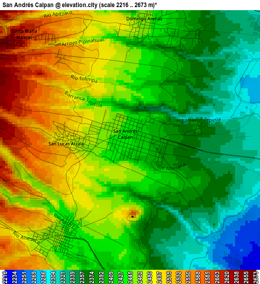
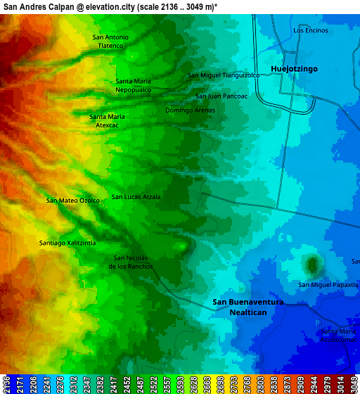
Below is the Elevation map of San Andrés Calpan, which displays elevation range with different colors. Scale of the first map is from 2216 to 2673 m (7270 to 8770 ft) with average elevation of 2431.2 meters (=7976 ft) [note 1]
These maps also provides idea of topography and contour of this city, they are displayed at different zoom levels. More info about maps, scale and edge coordinates you can find below images.
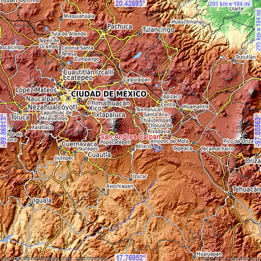
| \ | Map #1 | Map #2 | Topo.Map |
| Scale [m] | 2216..2673 m | 2136..3049 m | × |
| Scale [ft] | 7270..8770 ft | 7008..10003 ft | × |
| Average | 2431.2 m = 7976 ft | 2458.2 m = 8065 ft | × |
| Width | 9.23 km = 5.7 mi | 18.47 km = 11.5 mi | 295.5 km = 183.6 mi |
| Height | 9.23 km = 5.7 mi | 18.47 km = 11.5 mi | 295.5 km = 183.6 mi |
| ↑Max Latitude | 19.14508° | 19.186589° | 20.42693° |
| Latitude at center | 19.10356° | 19.10356° | 19.10356° |
| ↓Min Latitude | 19.06203° | 19.020489° | 17.76952° |
| ← Min Longitude | -98.505825° | -98.549771° | -99.86813° |
| Longitude center | -98.46188° | -98.46188° | -98.46188° |
| →Max Longitude | -98.417935° | -98.373989° | -97.05563° |
Nearby cities:
Cities around San Andrés Calpan sort by population:
• Huejotzingo elevation 2275 m
8.3 km,  42°
42°
• Nealtican 2236 m
7 km,  148°
148°
• Domingo Arenas 2447 m
4.1 km,  7°
7°
• San Nicolás de los Ranchos 2448 m
4.4 km,  215°
215°
• Santa María Nepopualco 2584 m
6.1 km,  329°
329°
• Santa María Atexcac 2603 m
5.1 km,  314°
314°
• San Mateo Ozolco 2680 m
5.7 km,  265°
265°
• San Pedro Yancuitlalpan 2437 m
3.7 km, 217°
• San Lucas Atzala 2488 m
2.1 km, 270°
• San Miguel Tianguizolco 2358 m
6.5 km,  19°
19°
• Xalitzintla 2565 m
6.2 km,  246°
246°
• San Juan Pancoac 2380 m
5.5 km, 22°
Multilingual:
 En español:
San Andrés Calpan elevación 2427 m.
 En France:
San Andrés Calpan élévation 2427 m.
 Auf Deutsch:
San Andrés Calpan höhe über dem Meeresspiegel ist 2427 m.
 На русском:
San Andrés Calpan высота над уровнем моря 2427 м
Sources and notes:
- [note 1] Map square and city borders are not equal. Map elevation data is calculated only from area inside that square.
- [src 1] Elevation data from geonames database provided with same terms of usage.
- [src 2] The elevation map of San Andrés Calpan is generated using elevation data from NASA's 3 arcsec (90m) resolution SRTM data.
- [src 3] Base (background) map © OpenStreetMap contributors tiles are generated by Geofabrik and OpenTopoMap.
Copyright & License:
This San Andrés Calpan Elevation Map is licensed under CC BY-SA. You may reuse any part from this page, if you give a proper credit by linking to this URL:
 More info on terms of use page.