Nealtican elevation
Nealtican (Puebla), Mexico elevation is 2236 meters and Nealtican elevation in feet is 7336 ft above sea level [src 1]. Nealtican is a seat of a second-order administrative division (feature code) with elevation that is 922 meters (3025 ft) bigger than average city elevation in Mexico.
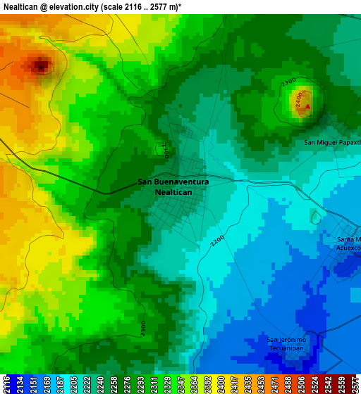
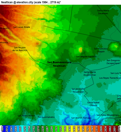
Below is the Elevation map of Nealtican, which displays elevation range with different colors. Scale of the first map is from 2116 to 2577 m (6942 to 8455 ft) with average elevation of 2275.9 meters (=7467 ft) [note 1]
These maps also provides idea of topography and contour of this city, they are displayed at different zoom levels. More info about maps, scale and edge coordinates you can find below images.
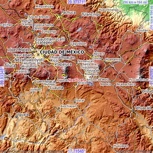
| \ | Map #1 | Map #2 | Topo.Map |
| Scale [m] | 2116..2577 m | 1984..2719 m | × |
| Scale [ft] | 6942..8455 ft | 6509..8921 ft | × |
| Average | 2275.9 m = 7467 ft | 2293.1 m = 7523 ft | × |
| Width | 9.24 km = 5.7 mi | 18.47 km = 11.5 mi | 295.6 km = 183.7 mi |
| Height | 9.24 km = 5.7 mi | 18.47 km = 11.5 mi | 295.6 km = 183.7 mi |
| ↑Max Latitude | 19.091433° | 19.132956° | 20.37371° |
| Latitude at center | 19.0499° | 19.0499° | 19.0499° |
| ↓Min Latitude | 19.008356° | 18.966802° | 17.71545° |
| ← Min Longitude | -98.471145° | -98.515091° | -99.83345° |
| Longitude center | -98.4272° | -98.4272° | -98.4272° |
| →Max Longitude | -98.383255° | -98.339309° | -97.02095° |
Nearby cities:
Cities around Nealtican sort by population:
• San Andrés Calpan elevation 2427 m
7 km,  328°
328°
• Zacapechpan 2175 m
8 km,  86°
86°
• San Nicolás de los Ranchos 2448 m
6.6 km,  291°
291°
• Tianguismanalco 2168 m
8.5 km,  195°
195°
• Acuexcomac 2164 m
4.6 km,  107°
107°
• San Pedro Yancuitlalpan 2437 m
6.6 km,  297°
297°
• San Francisco Cuapa 2197 m
6.8 km,  72°
72°
• San Lucas Atzala 2488 m
8.3 km,  316°
316°
• Tecuanipan 2159 m
5.1 km,  143°
143°
• Santa Isabel Cholula 2120 m
7.8 km, 139°
• Los Reyes Tlanechicolpan 2160 m
8.1 km,  103°
103°
• San Miguel Papaxtla 2238 m
4.2 km, 69°
Multilingual:
 En español:
Nealtican elevación 2236 m.
 En France:
Nealtican élévation 2236 m.
 Auf Deutsch:
Nealtican höhe über dem Meeresspiegel ist 2236 m.

Sources and notes:
- [note 1] Map square and city borders are not equal. Map elevation data is calculated only from area inside that square.
- [src 1] Elevation data from geonames database provided with same terms of usage.
- [src 2] The elevation map of Nealtican is generated using elevation data from NASA's 3 arcsec (90m) resolution SRTM data.
- [src 3] Base (background) map © OpenStreetMap contributors tiles are generated by Geofabrik and OpenTopoMap.
Copyright & License:
This Nealtican Elevation Map is licensed under CC BY-SA. You may reuse any part from this page, if you give a proper credit by linking to this URL:
 More info on terms of use page.