San Antonio la Isla elevation
San Antonio la Isla (State of Mexico), Mexico elevation is 2589 meters and San Antonio la Isla elevation in feet is 8494 ft above sea level [src 1]. San Antonio la Isla is a seat of a second-order administrative division (feature code) with elevation that is 1275 meters (4183 ft) bigger than average city elevation in Mexico.
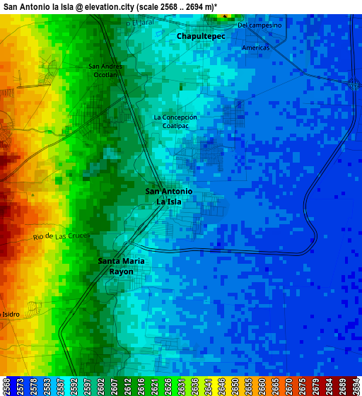
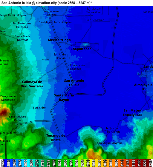
Below is the Elevation map of San Antonio la Isla, which displays elevation range with different colors. Scale of the first map is from 2568 to 2694 m (8425 to 8839 ft) with average elevation of 2599.4 meters (=8528 ft) [note 1]
These maps also provides idea of topography and contour of this city, they are displayed at different zoom levels. More info about maps, scale and edge coordinates you can find below images.
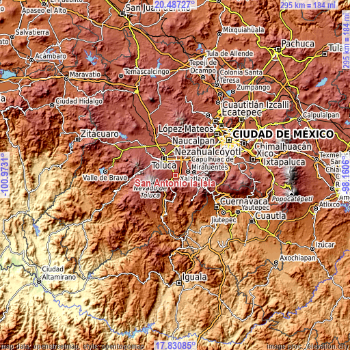
| \ | Map #1 | Map #2 | Topo.Map |
| Scale [m] | 2568..2694 m | 2568..3247 m | × |
| Scale [ft] | 8425..8839 ft | 8425..10653 ft | × |
| Average | 2599.4 m = 8528 ft | 2656.2 m = 8715 ft | × |
| Width | 9.23 km = 5.7 mi | 18.46 km = 11.5 mi | 295.4 km = 183.6 mi |
| Height | 9.23 km = 5.7 mi | 18.46 km = 11.5 mi | 295.4 km = 183.6 mi |
| ↑Max Latitude | 19.205915° | 19.247409° | 20.48727° |
| Latitude at center | 19.16441° | 19.16441° | 19.16441° |
| ↓Min Latitude | 19.122895° | 19.081369° | 17.83085° |
| ← Min Longitude | -99.610795° | -99.654741° | -100.9731° |
| Longitude center | -99.56685° | -99.56685° | -99.56685° |
| →Max Longitude | -99.522905° | -99.478959° | -98.1606° |
Nearby cities:
Cities around San Antonio la Isla sort by population:
• Calimaya elevation 2698 m
5.4 km,  268°
268°
• Mexicaltzingo 2605 m
5.5 km,  340°
340°
• Santa María Rayón 2595 m
2.3 km,  216°
216°
• Ex-Rancho San Dimas 2586 m
1.1 km,  8°
8°
• Chapultepec 2597 m
4.2 km, 7°
• San Andrés Ocotlán 2612 m
3.8 km,  327°
327°
• San Juan la Isla 2584 m
3.8 km,  186°
186°
• La Concepción Coatipac (La Conchita) 2595 m
1.9 km,  355°
355°
• Villas del Campo 2670 m
5.1 km,  290°
290°
• San Bartolito Tlaltelolco 2596 m
3.1 km, 10°
• Colonia Emiliano Zapata 2597 m
4.7 km,  198°
198°
• Colonia Arboledas (San Andrés) 2602 m
4.5 km, 340°
Multilingual:
 En español:
San Antonio la Isla elevación 2589 m.
 En France:
San Antonio la Isla élévation 2589 m.
 Auf Deutsch:
San Antonio la Isla höhe über dem Meeresspiegel ist 2589 m.
 На русском:
San Antonio la Isla высота над уровнем моря 2589 м
Sources and notes:
- [note 1] Map square and city borders are not equal. Map elevation data is calculated only from area inside that square.
- [src 1] Elevation data from geonames database provided with same terms of usage.
- [src 2] The elevation map of San Antonio la Isla is generated using elevation data from NASA's 3 arcsec (90m) resolution SRTM data.
- [src 3] Base (background) map © OpenStreetMap contributors tiles are generated by Geofabrik and OpenTopoMap.
Copyright & License:
This San Antonio la Isla Elevation Map is licensed under CC BY-SA. You may reuse any part from this page, if you give a proper credit by linking to this URL:
 More info on terms of use page.