Chapultepec elevation
Chapultepec (State of Mexico), Mexico elevation is 2597 meters and Chapultepec elevation in feet is 8520 ft above sea level [src 1]. Chapultepec is a seat of a second-order administrative division (feature code) with elevation that is 1283 meters (4209 ft) bigger than average city elevation in Mexico.
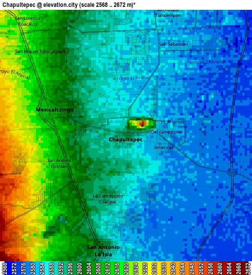
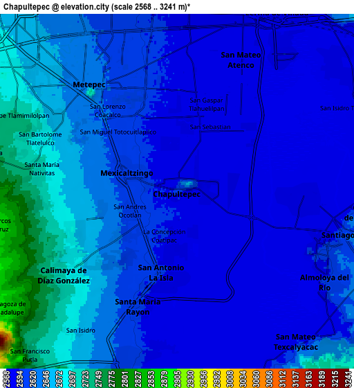
Below is the Elevation map of Chapultepec, which displays elevation range with different colors. Scale of the first map is from 2568 to 2672 m (8425 to 8766 ft) with average elevation of 2594.3 meters (=8511 ft) [note 1]
These maps also provides idea of topography and contour of this city, they are displayed at different zoom levels. More info about maps, scale and edge coordinates you can find below images.
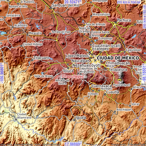
| \ | Map #1 | Map #2 | Topo.Map |
| Scale [m] | 2568..2672 m | 2568..3241 m | × |
| Scale [ft] | 8425..8766 ft | 8425..10633 ft | × |
| Average | 2594.3 m = 8511 ft | 2621.1 m = 8599 ft | × |
| Width | 9.23 km = 5.7 mi | 18.46 km = 11.5 mi | 295.3 km = 183.5 mi |
| Height | 9.23 km = 5.7 mi | 18.46 km = 11.5 mi | 295.3 km = 183.5 mi |
| ↑Max Latitude | 19.243655° | 19.28514° | 20.52471° |
| Latitude at center | 19.20216° | 19.20216° | 19.20216° |
| ↓Min Latitude | 19.160654° | 19.119138° | 17.86889° |
| ← Min Longitude | -99.605705° | -99.649651° | -100.96801° |
| Longitude center | -99.56176° | -99.56176° | -99.56176° |
| →Max Longitude | -99.517815° | -99.473869° | -98.15551° |
Nearby cities:
Cities around Chapultepec sort by population:
• San Antonio la Isla elevation 2589 m
4.2 km,  187°
187°
• Mexicaltzingo 2605 m
2.6 km,  292°
292°
• San Gaspar Tlahuelilpan 2582 m
4.8 km,  20°
20°
• Ex-Rancho San Dimas 2586 m
3.2 km, 186°
• San Miguel Totocuitlapilco 2616 m
4.5 km,  311°
311°
• San Andrés Ocotlán 2612 m
2.8 km,  248°
248°
• Unidad Habitacional Santa Teresa 2583 m
1.8 km,  32°
32°
• La Concepción Coatipac (La Conchita) 2595 m
2.4 km,  197°
197°
• San Sebastián 2582 m
3.8 km, 27°
• Colonia Agrícola Álvaro Obregón 2586 m
2.9 km,  12°
12°
• San Bartolito Tlaltelolco 2596 m
1.2 km,  177°
177°
• Colonia Arboledas (San Andrés) 2602 m
2 km,  271°
271°
Multilingual:
 En español:
Chapultepec elevación 2597 m.
 En France:
Chapultepec élévation 2597 m.
 Auf Deutsch:
Chapultepec höhe über dem Meeresspiegel ist 2597 m.

Sources and notes:
- [note 1] Map square and city borders are not equal. Map elevation data is calculated only from area inside that square.
- [src 1] Elevation data from geonames database provided with same terms of usage.
- [src 2] The elevation map of Chapultepec is generated using elevation data from NASA's 3 arcsec (90m) resolution SRTM data.
- [src 3] Base (background) map © OpenStreetMap contributors tiles are generated by Geofabrik and OpenTopoMap.
Copyright & License:
This Chapultepec Elevation Map is licensed under CC BY-SA. You may reuse any part from this page, if you give a proper credit by linking to this URL:
 More info on terms of use page.