San Gaspar Tlahuelilpan elevation
San Gaspar Tlahuelilpan (Morelos), Mexico elevation is 2582 meters and San Gaspar Tlahuelilpan elevation in feet is 8471 ft above sea level [src 1]. San Gaspar Tlahuelilpan is a populated place (feature code) with elevation that is 1268 meters (4160 ft) bigger than average city elevation in Mexico.
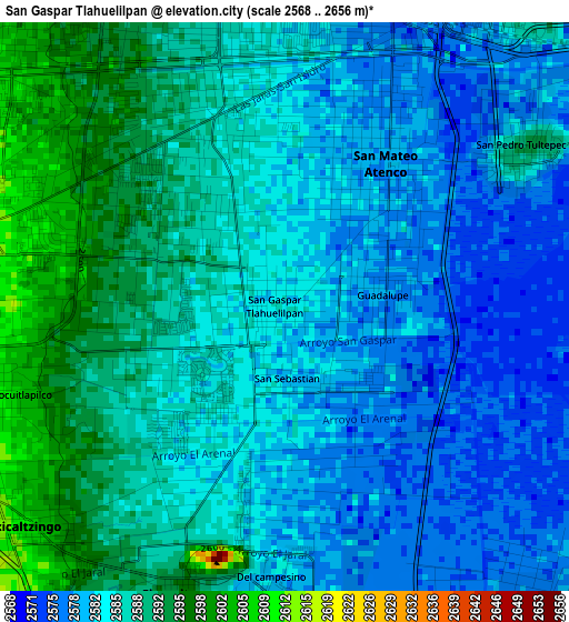
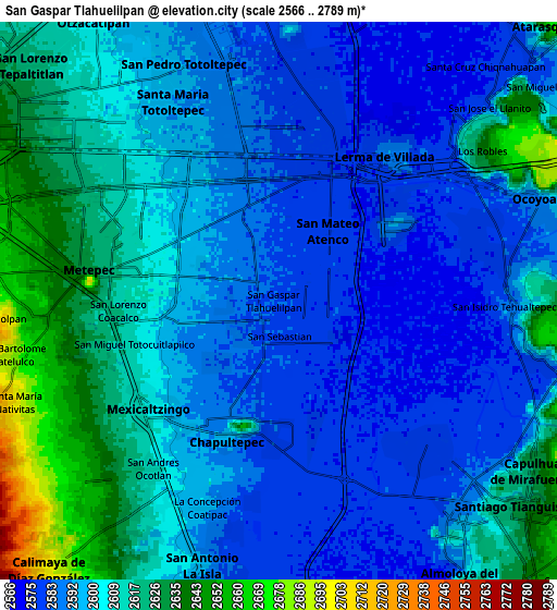
Below is the Elevation map of San Gaspar Tlahuelilpan, which displays elevation range with different colors. Scale of the first map is from 2568 to 2656 m (8425 to 8714 ft) with average elevation of 2584.9 meters (=8481 ft) [note 1]
These maps also provides idea of topography and contour of this city, they are displayed at different zoom levels. More info about maps, scale and edge coordinates you can find below images.
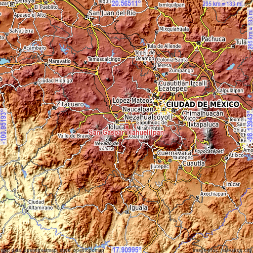
| \ | Map #1 | Map #2 | Topo.Map |
| Scale [m] | 2568..2656 m | 2566..2789 m | × |
| Scale [ft] | 8425..8714 ft | 8419..9150 ft | × |
| Average | 2584.9 m = 8481 ft | 2601.8 m = 8536 ft | × |
| Width | 9.23 km = 5.7 mi | 18.45 km = 11.5 mi | 295.2 km = 183.4 mi |
| Height | 9.23 km = 5.7 mi | 18.45 km = 11.5 mi | 295.2 km = 183.4 mi |
| ↑Max Latitude | 19.284385° | 19.325859° | 20.56511° |
| Latitude at center | 19.2429° | 19.2429° | 19.2429° |
| ↓Min Latitude | 19.201405° | 19.159899° | 17.90995° |
| ← Min Longitude | -99.589625° | -99.633571° | -100.95193° |
| Longitude center | -99.54568° | -99.54568° | -99.54568° |
| →Max Longitude | -99.501735° | -99.457789° | -98.13943° |
Nearby cities:
Cities around San Gaspar Tlahuelilpan sort by population:
• San Mateo Atenco elevation 2580 m
3.1 km,  27°
27°
• San Salvador Tizatlalli 2612 m
5.1 km,  292°
292°
• San Pedro Tultepec 2592 m
4.5 km,  57°
57°
• Mexicaltzingo 2605 m
5.4 km,  229°
229°
• San Miguel Totocuitlapilco 2616 m
5.3 km,  252°
252°
• Atizapán 2580 m
0.9 km,  330°
330°
• Chapultepec 2597 m
4.8 km,  200°
200°
• Santa María la Asunción 2585 m
2.8 km,  345°
345°
• Unidad Habitacional Santa Teresa 2583 m
3.1 km,  192°
192°
• San Sebastián 2582 m
1.2 km,  176°
176°
• Colonia Agrícola Álvaro Obregón 2586 m
2 km,  212°
212°
• Colonia Arboledas (San Andrés) 2602 m
5.8 km,  219°
219°
Multilingual:
 En español:
San Gaspar Tlahuelilpan elevación 2582 m.
 En France:
San Gaspar Tlahuelilpan élévation 2582 m.
 Auf Deutsch:
San Gaspar Tlahuelilpan höhe über dem Meeresspiegel ist 2582 m.
 На русском:
San Gaspar Tlahuelilpan высота над уровнем моря 2582 м
Sources and notes:
- [note 1] Map square and city borders are not equal. Map elevation data is calculated only from area inside that square.
- [src 1] Elevation data from geonames database provided with same terms of usage.
- [src 2] The elevation map of San Gaspar Tlahuelilpan is generated using elevation data from NASA's 3 arcsec (90m) resolution SRTM data.
- [src 3] Base (background) map © OpenStreetMap contributors tiles are generated by Geofabrik and OpenTopoMap.
Copyright & License:
This San Gaspar Tlahuelilpan Elevation Map is licensed under CC BY-SA. You may reuse any part from this page, if you give a proper credit by linking to this URL:
 More info on terms of use page.