Cuicatlan elevation
Cuicatlan (Oaxaca, San Juan Bautista Cuicatlán), Mexico elevation is 668 meters and Cuicatlan elevation in feet is 2192 ft above sea level [src 1]. Cuicatlan is a populated place (feature code) with elevation that is 646 meters (2119 ft) smaller than average city elevation in Mexico.
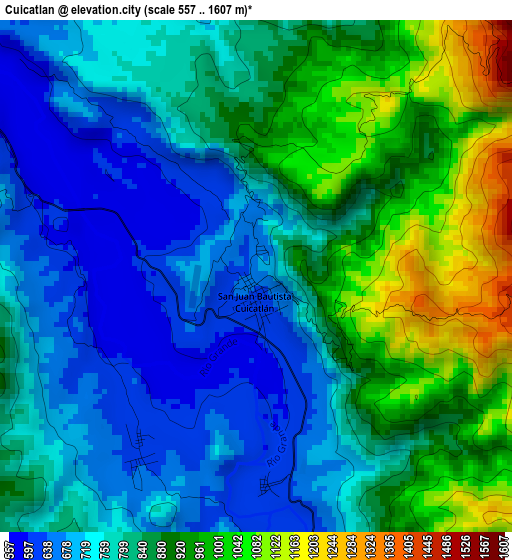
Below is the Elevation map of Cuicatlan, which displays elevation range with different colors. Scale of the first map is from 557 to 1607 m (1827 to 5272 ft) with average elevation of 824.9 meters (=2706 ft) [note 1]
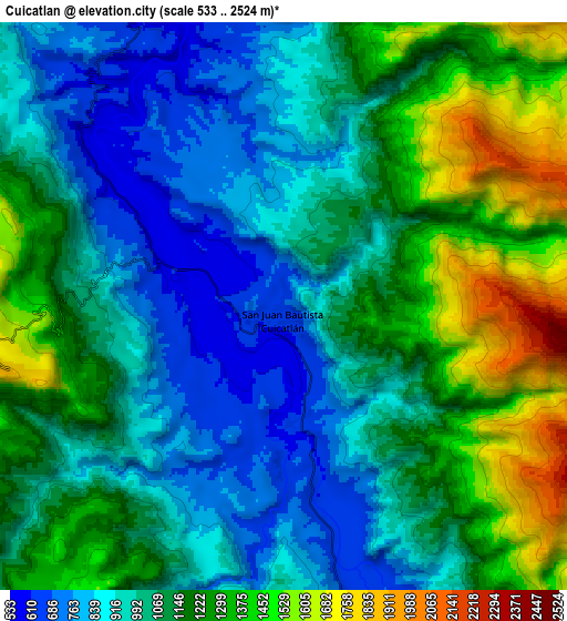
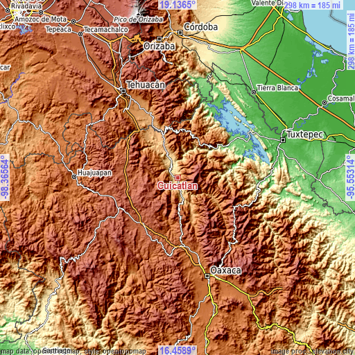
These maps also provides idea of topography and contour of this city, they are displayed at different zoom levels. More info about maps, scale and edge coordinates you can find below images.
| \ | Map #1 | Map #2 | Topo.Map |
| Scale [m] | 557..1607 m | 533..2524 m | × |
| Scale [ft] | 1827..5272 ft | 1749..8281 ft | × |
| Average | 824.9 m = 2706 ft | 1095 m = 3593 ft | × |
| Width | 9.3 km = 5.8 mi | 18.61 km = 11.6 mi | 297.7 km = 185 mi |
| Height | 9.3 km = 5.8 mi | 18.61 km = 11.6 mi | 297.7 km = 185 mi |
| ↑Max Latitude | 17.844556° | 17.886382° | 19.1365° |
| Latitude at center | 17.80272° | 17.80272° | 17.80272° |
| ↓Min Latitude | 17.760874° | 17.719018° | 16.4589° |
| ← Min Longitude | -97.003335° | -97.047281° | -98.36564° |
| Longitude center | -96.95939° | -96.95939° | -96.95939° |
| →Max Longitude | -96.915445° | -96.871499° | -95.55314° |
Nearby cities:
Cities around Cuicatlan sort by population:
• Santos Reyes Pápalo elevation 2098 m
10.4 km,  88°
88°
• Tecomavaca 616 m
18.3 km,  338°
338°
• Santa María Pápalo 2069 m
17.3 km,  96°
96°
• San Juan de los Cues 867 m
29.1 km, 338°
• San Juan Sautla 1050 m
30.8 km,  78°
78°
• Texcatitlán 1503 m
15.1 km,  228°
228°
• Mazatlán Villa de Flores 1145 m
26 km,  10°
10°
• Jaltepetongo 1799 m
15.3 km,  211°
211°
• Santa María Apazco 2178 m
23.9 km,  218°
218°
• Chicahua 2309 m
31 km, 233°
• Apoala 1980 m
25.4 km, 227°
• San Miguel Huautla 1932 m
19.9 km,  251°
251°
Multilingual:
 En español:
Cuicatlan elevación 668 m.
 En France:
Cuicatlan élévation 668 m.
 Auf Deutsch:
Cuicatlan höhe über dem Meeresspiegel ist 668 m.

Sources and notes:
- [note 1] Map square and city borders are not equal. Map elevation data is calculated only from area inside that square.
- [src 1] Elevation data from geonames database provided with same terms of usage.
- [src 2] The elevation map of Cuicatlan is generated using elevation data from NASA's 3 arcsec (90m) resolution SRTM data.
- [src 3] Base (background) map © OpenStreetMap contributors tiles are generated by Geofabrik and OpenTopoMap.
Copyright & License:
This Cuicatlan Elevation Map is licensed under CC BY-SA. You may reuse any part from this page, if you give a proper credit by linking to this URL:
 More info on terms of use page.