Tecomavaca elevation
Tecomavaca (Oaxaca, Santa María Tecomavaca), Mexico elevation is 616 meters and Tecomavaca elevation in feet is 2021 ft above sea level [src 1]. Tecomavaca is a populated place (feature code) with elevation that is 698 meters (2290 ft) smaller than average city elevation in Mexico.
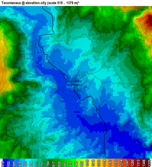
Below is the Elevation map of Tecomavaca, which displays elevation range with different colors. Scale of the first map is from 519 to 1379 m (1703 to 4524 ft) with average elevation of 712 meters (=2336 ft) [note 1]
These maps also provides idea of topography and contour of this city, they are displayed at different zoom levels. More info about maps, scale and edge coordinates you can find below images.
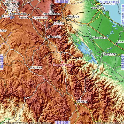
| \ | Map #1 | Topo.Map |
| Scale [m] | 519..1379 m | × |
| Scale [ft] | 1703..4524 ft | × |
| Average | 712 m = 2336 ft | × |
| Width | 9.3 km = 5.8 mi | 297.5 km = 184.9 mi |
| Height | 9.3 km = 5.8 mi | 297.5 km = 184.9 mi |
| ↑Max Latitude | 17.99757° | 19.28836° |
| Latitude at center | 17.95577° | 17.95577° |
| ↓Min Latitude | 17.91396° | 16.61306° |
| ← Min Longitude | -97.066575° | -98.42888° |
| Longitude center | -97.02263° | -97.02263° |
| →Max Longitude | -96.978685° | -95.61638° |
Nearby cities:
Cities around Tecomavaca sort by population:
• Teotitlán elevation 1042 m
20.2 km,  345°
345°
• Cuicatlan 668 m
18.3 km,  158°
158°
• Santos Reyes Pápalo 2098 m
23.9 km,  134°
134°
• San José Tilapa 922 m
24.6 km,  340°
340°
• Toxpalan 1030 m
16.6 km, 346°
• San Juan de los Cues 867 m
10.8 km, 338°
• Xochitonalco 1660 m
24 km,  50°
50°
• Mazatlán Villa de Flores 1145 m
14.3 km, 53°
• San Jerónimo Tecóatl 1861 m
26.1 km,  26°
26°
• Santa María Teopoxco 1875 m
24.5 km,  16°
16°
• San Lucas Zoquiápam 1760 m
23.6 km, 31°
• Nanahuatípam 801 m
22.6 km,  331°
331°
Multilingual:
 En español:
Tecomavaca elevación 616 m.
 En France:
Tecomavaca élévation 616 m.
 Auf Deutsch:
Tecomavaca höhe über dem Meeresspiegel ist 616 m.

Sources and notes:
- [note 1] Map square and city borders are not equal. Map elevation data is calculated only from area inside that square.
- [src 1] Elevation data from geonames database provided with same terms of usage.
- [src 2] The elevation map of Tecomavaca is generated using elevation data from NASA's 3 arcsec (90m) resolution SRTM data.
- [src 3] Base (background) map © OpenStreetMap contributors tiles are generated by Geofabrik and OpenTopoMap.
Copyright & License:
This Tecomavaca Elevation Map is licensed under CC BY-SA. You may reuse any part from this page, if you give a proper credit by linking to this URL:
 More info on terms of use page.