Tecuanipa elevation
Tecuanipa (Puebla, Tochimilco), Mexico elevation is 2291 meters and Tecuanipa elevation in feet is 7516 ft above sea level [src 1]. Tecuanipa is a populated place (feature code) with elevation that is 977 meters (3205 ft) bigger than average city elevation in Mexico.
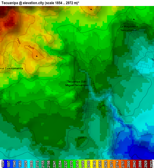
Below is the Elevation map of Tecuanipa, which displays elevation range with different colors. Scale of the first map is from 1854 to 2972 m (6083 to 9751 ft) with average elevation of 2274.3 meters (=7462 ft) [note 1]
These maps also provides idea of topography and contour of this city, they are displayed at different zoom levels. More info about maps, scale and edge coordinates you can find below images.
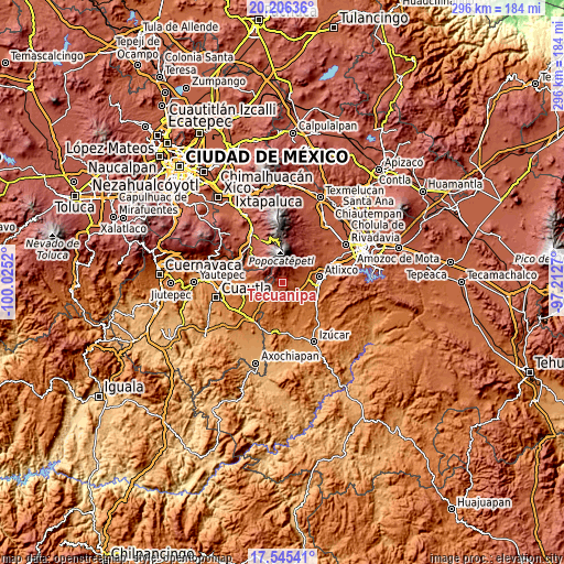
| \ | Map #1 | Topo.Map |
| Scale [m] | 1854..2972 m | × |
| Scale [ft] | 6083..9751 ft | × |
| Average | 2274.3 m = 7462 ft | × |
| Width | 9.25 km = 5.7 mi | 295.9 km = 183.9 mi |
| Height | 9.25 km = 5.7 mi | 295.9 km = 183.9 mi |
| ↑Max Latitude | 18.922746° | 20.20636° |
| Latitude at center | 18.88117° | 18.88117° |
| ↓Min Latitude | 18.839584° | 17.54541° |
| ← Min Longitude | -98.662895° | -100.0252° |
| Longitude center | -98.61895° | -98.61895° |
| →Max Longitude | -98.575005° | -97.2127° |
Nearby cities:
Cities around Tecuanipa sort by population:
• Hueyapan elevation 2360 m
6.7 km,  278°
278°
• San Juan Amecac 2079 m
6.7 km,  219°
219°
• Tochimilco 2055 m
5.1 km,  78°
78°
• San Pedro Benito Juárez 2337 m
10.2 km,  44°
44°
• San Antonio Alpanocan 2096 m
9.7 km,  267°
267°
• San Juan Tejupa 1848 m
8.7 km,  109°
109°
• La Magdalena Yancuitlalpan 2218 m
4.5 km, 43°
• Colonia Agrícola de Ocotepec (Colonia San José) 2154 m
9.5 km,  55°
55°
• Santa Cruz Cuautomatitla 2519 m
4.3 km, 281°
• Tulcingo 1964 m
5.5 km,  153°
153°
• San Miguel Aguacomulican 1747 m
9.7 km,  132°
132°
• Santiago Atzitzihuacán 1820 m
7.4 km, 147°
Multilingual:
 En español:
San Miguel elevación 2291 m.
 En France:
Tecuanipa élévation 2291 m.
 Auf Deutsch:
Tecuanipa höhe über dem Meeresspiegel ist 2291 m.

Sources and notes:
- [note 1] Map square and city borders are not equal. Map elevation data is calculated only from area inside that square.
- [src 1] Elevation data from geonames database provided with same terms of usage.
- [src 2] The elevation map of Tecuanipa is generated using elevation data from NASA's 3 arcsec (90m) resolution SRTM data.
- [src 3] Base (background) map © OpenStreetMap contributors tiles are generated by Geofabrik and OpenTopoMap.
Copyright & License:
This Tecuanipa Elevation Map is licensed under CC BY-SA. You may reuse any part from this page, if you give a proper credit by linking to this URL:
 More info on terms of use page.