San Juan Tejupa elevation
San Juan Tejupa (Puebla, Atzitzihuacán), Mexico elevation is 1848 meters and San Juan Tejupa elevation in feet is 6063 ft above sea level [src 1]. San Juan Tejupa is a populated place (feature code) with elevation that is 534 meters (1752 ft) bigger than average city elevation in Mexico.
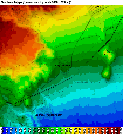
Below is the Elevation map of San Juan Tejupa, which displays elevation range with different colors. Scale of the first map is from 1698 to 2137 m (5571 to 7011 ft) with average elevation of 1880.1 meters (=6168 ft) [note 1]
These maps also provides idea of topography and contour of this city, they are displayed at different zoom levels. More info about maps, scale and edge coordinates you can find below images.
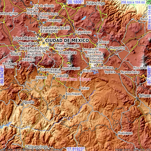
| \ | Map #1 | Topo.Map |
| Scale [m] | 1698..2137 m | × |
| Scale [ft] | 5571..7011 ft | × |
| Average | 1880.1 m = 6168 ft | × |
| Width | 9.25 km = 5.7 mi | 295.9 km = 183.9 mi |
| Height | 9.25 km = 5.7 mi | 295.9 km = 183.9 mi |
| ↑Max Latitude | 18.896772° | 20.1806° |
| Latitude at center | 18.85519° | 18.85519° |
| ↓Min Latitude | 18.813598° | 17.51923° |
| ← Min Longitude | -98.585185° | -99.94749° |
| Longitude center | -98.54124° | -98.54124° |
| →Max Longitude | -98.497295° | -97.13499° |
Nearby cities:
Cities around San Juan Tejupa sort by population:
• San Jerónimo Coyula elevation 1954 m
5 km,  30°
30°
• Tochimilco 2055 m
5.1 km,  321°
321°
• Huaquechula 1597 m
9.3 km,  182°
182°
• La Magdalena Yancuitlalpan 2218 m
8 km, 320°
• Soledad Morelos 1742 m
6.2 km,  118°
118°
• Colonia Agrícola de Ocotepec (Colonia San José) 2154 m
8.3 km,  357°
357°
• Teacalco de Dorantes (San José Teacalco) 1684 m
6.7 km,  147°
147°
• Tronconal 1682 m
8.2 km,  132°
132°
• Tecuanipa 2291 m
8.7 km,  289°
289°
• Tulcingo 1964 m
6.1 km,  250°
250°
• San Miguel Aguacomulican 1747 m
3.8 km,  194°
194°
• Santiago Atzitzihuacán 1820 m
5.4 km,  231°
231°
Multilingual:
 En español:
San Juan Tejupa elevación 1848 m.
 En France:
San Juan Tejupa élévation 1848 m.
 Auf Deutsch:
San Juan Tejupa höhe über dem Meeresspiegel ist 1848 m.

Sources and notes:
- [note 1] Map square and city borders are not equal. Map elevation data is calculated only from area inside that square.
- [src 1] Elevation data from geonames database provided with same terms of usage.
- [src 2] The elevation map of San Juan Tejupa is generated using elevation data from NASA's 3 arcsec (90m) resolution SRTM data.
- [src 3] Base (background) map © OpenStreetMap contributors tiles are generated by Geofabrik and OpenTopoMap.
Copyright & License:
This San Juan Tejupa Elevation Map is licensed under CC BY-SA. You may reuse any part from this page, if you give a proper credit by linking to this URL:
 More info on terms of use page.