San Miguel Tenango elevation
San Miguel Tenango (Oaxaca), Mexico elevation is 1613 meters and San Miguel Tenango elevation in feet is 5292 ft above sea level [src 1]. San Miguel Tenango is a seat of a second-order administrative division (feature code) with elevation that is 299 meters (981 ft) bigger than average city elevation in Mexico.
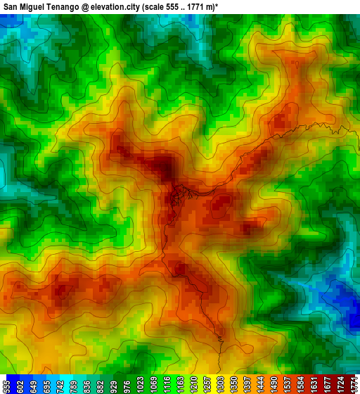
Below is the Elevation map of San Miguel Tenango, which displays elevation range with different colors. Scale of the first map is from 555 to 1771 m (1821 to 5810 ft) with average elevation of 1208 meters (=3963 ft) [note 1]
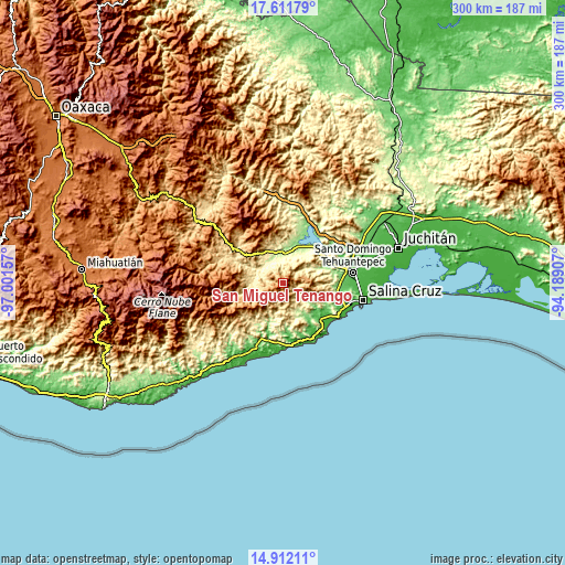
These maps also provides idea of topography and contour of this city, they are displayed at different zoom levels. More info about maps, scale and edge coordinates you can find below images.
| \ | Map #1 | Topo.Map |
| Scale [m] | 555..1771 m | × |
| Scale [ft] | 1821..5810 ft | × |
| Average | 1208 m = 3963 ft | × |
| Width | 9.38 km = 5.8 mi | 300.2 km = 186.5 mi |
| Height | 9.38 km = 5.8 mi | 300.2 km = 186.5 mi |
| ↑Max Latitude | 16.308772° | 17.61179° |
| Latitude at center | 16.26659° | 16.26659° |
| ↓Min Latitude | 16.224399° | 14.91211° |
| ← Min Longitude | -95.639265° | -97.00157° |
| Longitude center | -95.59532° | -95.59532° |
| →Max Longitude | -95.551375° | -94.18907° |
Nearby cities:
Cities around San Miguel Tenango sort by population:
• Santa María Jalapa del Marqués elevation 161 m
25.1 km,  39°
39°
• Jalapa 126 m
29.4 km,  27°
27°
• Magdalena Tequisistlán 204 m
14.8 km,  357°
357°
• El Morro 22 m
29.8 km,  129°
129°
• San Pedro Huamelula 81 m
27.7 km,  196°
196°
• Santiago Astata 38 m
32.2 km, 195°
• Santa María Huamelula 66 m
32.6 km, 200°
• El Carrizal 18 m
31.2 km,  136°
136°
• Santa María Zapotitlán 1504 m
31.5 km,  240°
240°
• Rincón Moreno 111 m
30.4 km,  97°
97°
• Asunción Tlacolulita 365 m
14.5 km,  284°
284°
• Santa María Ecatepec 1830 m
30.5 km,  273°
273°
Multilingual:
 En español:
San Miguel Tenango elevación 1613 m.
 En France:
San Miguel Tenango élévation 1613 m.
 Auf Deutsch:
San Miguel Tenango höhe über dem Meeresspiegel ist 1613 m.
 На русском:
San Miguel Tenango высота над уровнем моря 1613 м
Sources and notes:
- [note 1] Map square and city borders are not equal. Map elevation data is calculated only from area inside that square.
- [src 1] Elevation data from geonames database provided with same terms of usage.
- [src 2] The elevation map of San Miguel Tenango is generated using elevation data from NASA's 3 arcsec (90m) resolution SRTM data.
- [src 3] Base (background) map © OpenStreetMap contributors tiles are generated by Geofabrik and OpenTopoMap.
Copyright & License:
This San Miguel Tenango Elevation Map is licensed under CC BY-SA. You may reuse any part from this page, if you give a proper credit by linking to this URL:
 More info on terms of use page.