Rincón Moreno elevation
Rincón Moreno (Oaxaca, Santo Domingo Tehuantepec), Mexico elevation is 111 meters and Rincón Moreno elevation in feet is 364 ft above sea level [src 1]. Rincón Moreno is a populated place (feature code) with elevation that is 1203 meters (3947 ft) smaller than average city elevation in Mexico.
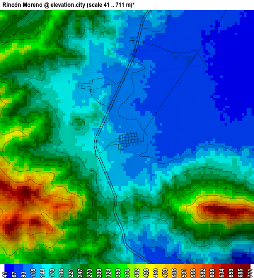
Below is the Elevation map of Rincón Moreno, which displays elevation range with different colors. Scale of the first map is from 41 to 711 m (135 to 2333 ft) with average elevation of 212.3 meters (=697 ft) [note 1]
These maps also provides idea of topography and contour of this city, they are displayed at different zoom levels. More info about maps, scale and edge coordinates you can find below images.
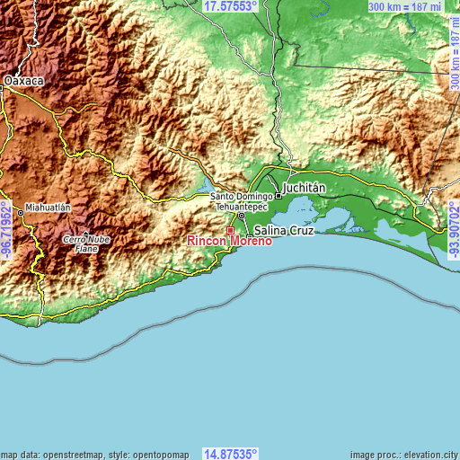
| \ | Map #1 | Topo.Map |
| Scale [m] | 41..711 m | × |
| Scale [ft] | 135..2333 ft | × |
| Average | 212.3 m = 697 ft | × |
| Width | 9.38 km = 5.8 mi | 300.2 km = 186.5 mi |
| Height | 9.38 km = 5.8 mi | 300.3 km = 186.6 mi |
| ↑Max Latitude | 16.272259° | 17.57553° |
| Latitude at center | 16.23007° | 16.23007° |
| ↓Min Latitude | 16.187872° | 14.87535° |
| ← Min Longitude | -95.357215° | -96.71952° |
| Longitude center | -95.31327° | -95.31327° |
| →Max Longitude | -95.269325° | -93.90702° |
Nearby cities:
Cities around Rincón Moreno sort by population:
• Salina Cruz elevation 54 m
14.1 km,  115°
115°
• Santo Domingo Tehuantepec 44 m
13 km,  36°
36°
• San Blas Atempa 54 m
14.6 km, 39°
• Santa María Mixtequilla 54 m
17.1 km,  19°
19°
• San Pedro Huilotepec 18 m
17.4 km,  84°
84°
• El Morro 22 m
16.3 km,  205°
205°
• Santa Rosa 12 m
24.8 km,  67°
67°
• La Noria 27 m
10.3 km, 74°
• Huazantlán del Río 25 m
19.7 km,  93°
93°
• El Carrizal 18 m
20.3 km,  204°
204°
• Colonia Jordán 34 m
21.3 km,  33°
33°
• Colonia San Luis 50 m
18.4 km, 24°
Multilingual:
 En español:
Rincón Moreno elevación 111 m.
 En France:
Rincón Moreno élévation 111 m.
 Auf Deutsch:
Rincón Moreno höhe über dem Meeresspiegel ist 111 m.

Sources and notes:
- [note 1] Map square and city borders are not equal. Map elevation data is calculated only from area inside that square.
- [src 1] Elevation data from geonames database provided with same terms of usage.
- [src 2] The elevation map of Rincón Moreno is generated using elevation data from NASA's 3 arcsec (90m) resolution SRTM data.
- [src 3] Base (background) map © OpenStreetMap contributors tiles are generated by Geofabrik and OpenTopoMap.
Copyright & License:
This Rincón Moreno Elevation Map is licensed under CC BY-SA. You may reuse any part from this page, if you give a proper credit by linking to this URL:
 More info on terms of use page.