Santa María Colotepec elevation
Santa María Colotepec (Oaxaca), Mexico elevation is 55 meters and Santa María Colotepec elevation in feet is 180 ft above sea level [src 1]. Santa María Colotepec is a seat of a second-order administrative division (feature code) with elevation that is 1259 meters (4131 ft) smaller than average city elevation in Mexico.
Below is the Elevation map of Santa María Colotepec, which displays elevation range with different colors. Scale of the first map is from 19 to 566 m (62 to 1857 ft) with average elevation of 179 meters (=587 ft) [note 1]
These maps also provides idea of topography and contour of this city, they are displayed at different zoom levels. More info about maps, scale and edge coordinates you can find below images.
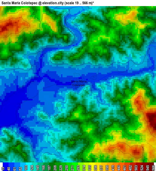
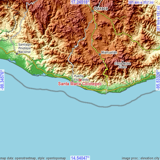
| \ | Map #1 | Topo.Map |
| Scale [m] | 19..566 m | × |
| Scale [ft] | 62..1857 ft | × |
| Average | 179 m = 587 ft | × |
| Width | 9.4 km = 5.8 mi | 300.7 km = 186.8 mi |
| Height | 9.4 km = 5.8 mi | 300.8 km = 186.9 mi |
| ↑Max Latitude | 15.93963° | 17.24518° |
| Latitude at center | 15.89737° | 15.89737° |
| ↓Min Latitude | 15.855101° | 14.54047° |
| ← Min Longitude | -96.983455° | -98.34576° |
| Longitude center | -96.93951° | -96.93951° |
| →Max Longitude | -96.895565° | -95.53326° |
Nearby cities:
Cities around Santa María Colotepec sort by population:
• Puerto Escondido elevation 75 m
15 km,  258°
258°
• Brisas de Zicatela 22 m
12.9 km,  238°
238°
• Bajos de Chila 24 m
19.6 km,  278°
278°
• San Gabriel Mixtepec 685 m
26.8 km,  325°
325°
• Santa Catarina Loxicha 1276 m
27.5 km,  46°
46°
• San Baltazar Loxicha 999 m
25.7 km,  39°
39°
• San Francisco Cozoaltepec 142 m
24.8 km,  111°
111°
• Santo Domingo de Morelos 157 m
30 km,  103°
103°
• San Bartolomé Loxícha 1211 m
25.9 km,  71°
71°
• La Barra de Colotepec 37 m
12.5 km,  230°
230°
• Quelové 1290 m
29.4 km, 71°
• San Pedro Mixtepec 224 m
17.7 km,  302°
302°
Multilingual:
 En español:
Santa María Colotepec elevación 55 m.
 En France:
Santa María Colotepec élévation 55 m.
 Auf Deutsch:
Santa María Colotepec höhe über dem Meeresspiegel ist 55 m.
 На русском:
Santa María Colotepec высота над уровнем моря 55 м
Sources and notes:
- [note 1] Map square and city borders are not equal. Map elevation data is calculated only from area inside that square.
- [src 1] Elevation data from geonames database provided with same terms of usage.
- [src 2] The elevation map of Santa María Colotepec is generated using elevation data from NASA's 3 arcsec (90m) resolution SRTM data.
- [src 3] Base (background) map © OpenStreetMap contributors tiles are generated by Geofabrik and OpenTopoMap.
Copyright & License:
This Santa María Colotepec Elevation Map is licensed under CC BY-SA. You may reuse any part from this page, if you give a proper credit by linking to this URL:
 More info on terms of use page.