Puerto Escondido elevation
Puerto Escondido (Oaxaca, San Pedro Mixtepec -Dto. 22 -), Mexico elevation is 75 meters and Puerto Escondido elevation in feet is 246 ft above sea level [src 1]. Puerto Escondido is a populated place (feature code) with elevation that is 1239 meters (4065 ft) smaller than average city elevation in Mexico.
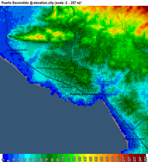
Below is the Elevation map of Puerto Escondido, which displays elevation range with different colors. Scale of the first map is from -2 to 257 m (-7 to 843 ft) with average elevation of 75.1 meters (=246 ft) [note 1]
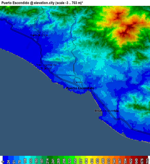
These maps also provides idea of topography and contour of this city, they are displayed at different zoom levels. More info about maps, scale and edge coordinates you can find below images.
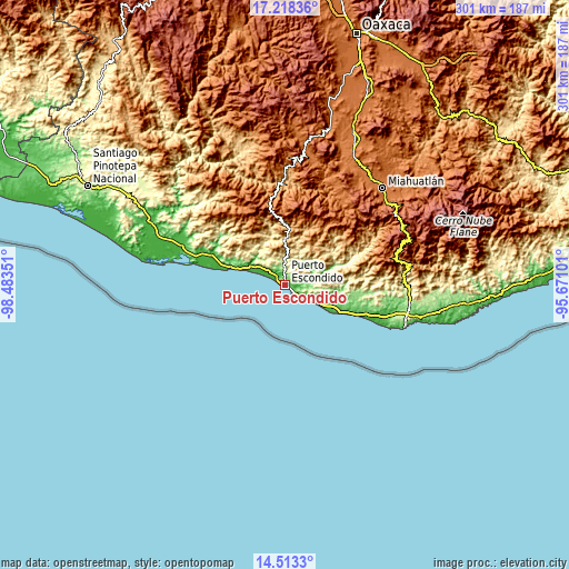
| \ | Map #1 | Map #2 | Topo.Map |
| Scale [m] | -2..257 m | -3..703 m | × |
| Scale [ft] | -7..843 ft | -10..2306 ft | × |
| Average | 75.1 m = 246 ft | 136.8 m = 449 ft | × |
| Width | 9.4 km = 5.8 mi | 18.8 km = 11.7 mi | 300.8 km = 186.9 mi |
| Height | 9.4 km = 5.8 mi | 18.8 km = 11.7 mi | 300.8 km = 186.9 mi |
| ↑Max Latitude | 15.912636° | 15.954893° | 17.21836° |
| Latitude at center | 15.87037° | 15.87037° | 15.87037° |
| ↓Min Latitude | 15.828095° | 15.785812° | 14.5133° |
| ← Min Longitude | -97.121205° | -97.165151° | -98.48351° |
| Longitude center | -97.07726° | -97.07726° | -97.07726° |
| →Max Longitude | -97.033315° | -96.989369° | -95.67101° |
Nearby cities:
Cities around Puerto Escondido sort by population:
• Brisas de Zicatela elevation 22 m
5.3 km,  134°
134°
• Bajos de Chila 24 m
7.5 km,  321°
321°
• Santos Reyes Nopala 478 m
27.3 km,  344°
344°
• San Gabriel Mixtepec 685 m
25.1 km,  358°
358°
• Santa María Tiltepec 477 m
23.6 km, 335°
• Santa Lucía Teotepec 1195 m
33.4 km, 335°
• Cerro del Aire 601 m
29.9 km,  332°
332°
• Santa María Colotepec 55 m
15 km,  78°
78°
• Santiago Cuixtla 437 m
24.3 km, 331°
• La Barra de Colotepec 37 m
7.2 km, 133°
• San Juan Lachao 597 m
32.5 km,  351°
351°
• San Pedro Mixtepec 224 m
12.4 km, 358°
Multilingual:
 En español:
Puerto Escondido elevación 75 m.
 En France:
Puerto Escondido élévation 75 m.
 Auf Deutsch:
Puerto Escondido höhe über dem Meeresspiegel ist 75 m.

Sources and notes:
- [note 1] Map square and city borders are not equal. Map elevation data is calculated only from area inside that square.
- [src 1] Elevation data from geonames database provided with same terms of usage.
- [src 2] The elevation map of Puerto Escondido is generated using elevation data from NASA's 3 arcsec (90m) resolution SRTM data.
- [src 3] Base (background) map © OpenStreetMap contributors tiles are generated by Geofabrik and OpenTopoMap.
Copyright & License:
This Puerto Escondido Elevation Map is licensed under CC BY-SA. You may reuse any part from this page, if you give a proper credit by linking to this URL:
 More info on terms of use page.