Tequisquiapan elevation
Tequisquiapan (Querétaro), Mexico elevation is 1881 meters and Tequisquiapan elevation in feet is 6171 ft above sea level [src 1]. Tequisquiapan is a populated place (feature code) with elevation that is 567 meters (1860 ft) bigger than average city elevation in Mexico.
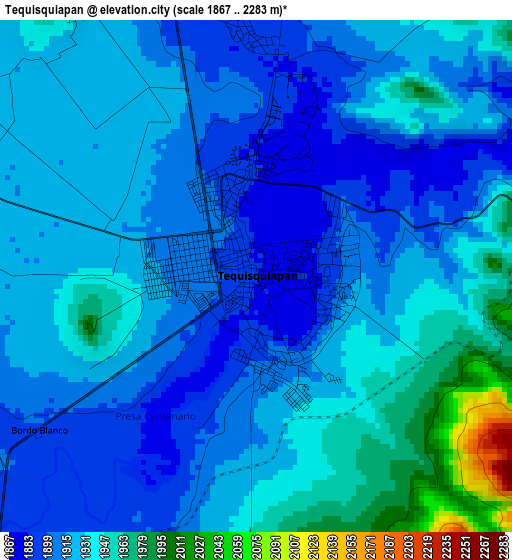
Below is the Elevation map of Tequisquiapan, which displays elevation range with different colors. Scale of the first map is from 1867 to 2283 m (6125 to 7490 ft) with average elevation of 1923.2 meters (=6310 ft) [note 1]
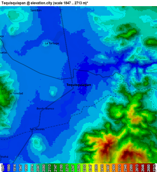
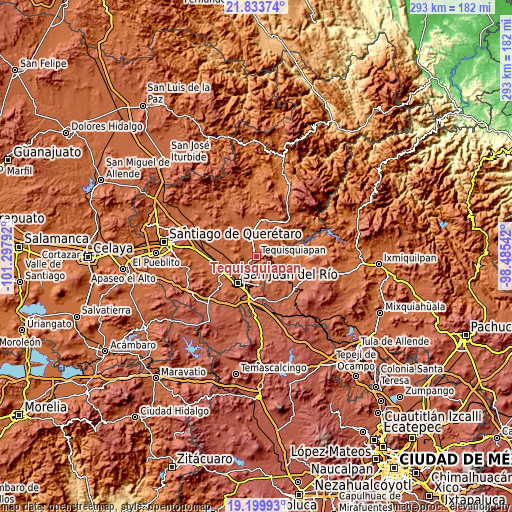
These maps also provides idea of topography and contour of this city, they are displayed at different zoom levels. More info about maps, scale and edge coordinates you can find below images.
| \ | Map #1 | Map #2 | Topo.Map |
| Scale [m] | 1867..2283 m | 1847..2713 m | × |
| Scale [ft] | 6125..7490 ft | 6060..8901 ft | × |
| Average | 1923.2 m = 6310 ft | 2000.3 m = 6563 ft | × |
| Width | 9.15 km = 5.7 mi | 18.3 km = 11.4 mi | 292.9 km = 182 mi |
| Height | 9.15 km = 5.7 mi | 18.3 km = 11.4 mi | 292.9 km = 182 mi |
| ↑Max Latitude | 20.563651° | 20.60479° | 21.83374° |
| Latitude at center | 20.5225° | 20.5225° | 20.5225° |
| ↓Min Latitude | 20.481338° | 20.440165° | 19.19993° |
| ← Min Longitude | -99.935615° | -99.979561° | -101.29792° |
| Longitude center | -99.89167° | -99.89167° | -99.89167° |
| →Max Longitude | -99.847725° | -99.803779° | -98.48542° |
Nearby cities:
Cities around Tequisquiapan sort by population:
• San Nicolás elevation 1899 m
7 km,  223°
223°
• La Llave 1903 m
12.3 km,  239°
239°
• Santa Rosa Xajay 2007 m
9.6 km,  184°
184°
• Visthá 1908 m
12.2 km,  226°
226°
• Fuentezuelas 1969 m
10.1 km,  291°
291°
• Bordo Blanco 1898 m
4.8 km, 232°
• La Tortuga 1926 m
5.9 km,  326°
326°
• La Trinidad 1965 m
7.4 km,  264°
264°
• El Ciervo 1987 m
10.8 km,  10°
10°
• Santillán 1922 m
10 km, 330°
• San Joaquín 1961 m
12.2 km,  98°
98°
• La Laja 1961 m
10.9 km,  302°
302°
Multilingual:
 En español:
Tequisquiapan elevación 1881 m.
 En France:
Tequisquiapan élévation 1881 m.
 Auf Deutsch:
Tequisquiapan höhe über dem Meeresspiegel ist 1881 m.

Sources and notes:
- [note 1] Map square and city borders are not equal. Map elevation data is calculated only from area inside that square.
- [src 1] Elevation data from geonames database provided with same terms of usage.
- [src 2] The elevation map of Tequisquiapan is generated using elevation data from NASA's 3 arcsec (90m) resolution SRTM data.
- [src 3] Base (background) map © OpenStreetMap contributors tiles are generated by Geofabrik and OpenTopoMap.
Copyright & License:
This Tequisquiapan Elevation Map is licensed under CC BY-SA. You may reuse any part from this page, if you give a proper credit by linking to this URL:
 More info on terms of use page.