Tetepango elevation
Tetepango (Hidalgo), Mexico elevation is 2100 meters and Tetepango elevation in feet is 6890 ft above sea level [src 1]. Tetepango is a populated place (feature code) with elevation that is 786 meters (2579 ft) bigger than average city elevation in Mexico.
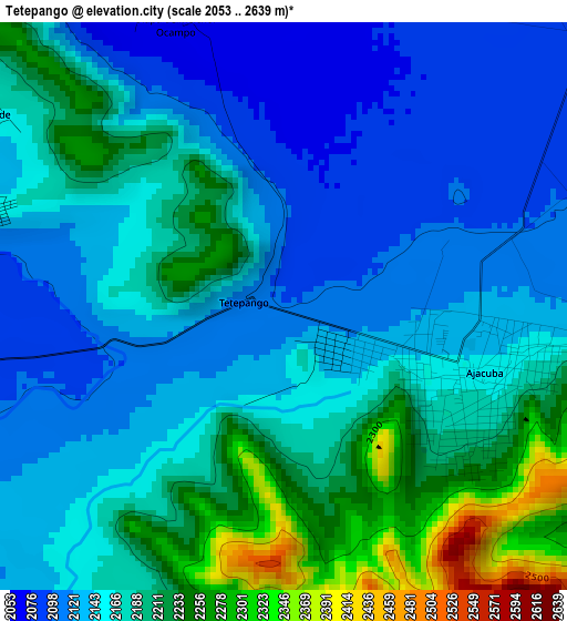
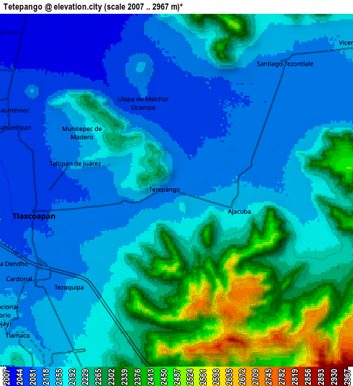
Below is the Elevation map of Tetepango, which displays elevation range with different colors. Scale of the first map is from 2053 to 2639 m (6736 to 8658 ft) with average elevation of 2166.7 meters (=7109 ft) [note 1]
These maps also provides idea of topography and contour of this city, they are displayed at different zoom levels. More info about maps, scale and edge coordinates you can find below images.
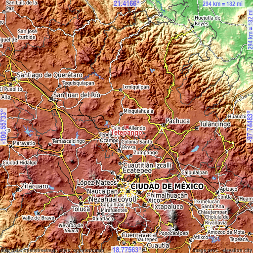
| \ | Map #1 | Map #2 | Topo.Map |
| Scale [m] | 2053..2639 m | 2007..2967 m | × |
| Scale [ft] | 6736..8658 ft | 6585..9734 ft | × |
| Average | 2166.7 m = 7109 ft | 2196.7 m = 7207 ft | × |
| Width | 9.18 km = 5.7 mi | 18.35 km = 11.4 mi | 293.6 km = 182.4 mi |
| Height | 9.18 km = 5.7 mi | 18.35 km = 11.4 mi | 293.7 km = 182.5 mi |
| ↑Max Latitude | 20.142943° | 20.184195° | 21.4166° |
| Latitude at center | 20.10168° | 20.10168° | 20.10168° |
| ↓Min Latitude | 20.060406° | 20.019122° | 18.77563° |
| ← Min Longitude | -99.195025° | -99.238971° | -100.55733° |
| Longitude center | -99.15108° | -99.15108° | -99.15108° |
| →Max Longitude | -99.107135° | -99.063189° | -97.74483° |
Nearby cities:
Cities around Tetepango sort by population:
• Tlaxcoapan elevation 2073 m
7.3 km,  261°
261°
• Cardonal 2112 m
9.7 km,  238°
238°
• Tlahuelilpan 2063 m
9 km,  291°
291°
• Ajacuba 2156 m
3.2 km,  110°
110°
• Doxey 2081 m
9.7 km, 263°
• Atitalaquia 2096 m
8.7 km, 237°
• Santiago Tezontlale 2114 m
8.7 km,  39°
39°
• Teltipán de Juárez 2114 m
5.5 km, 286°
• Tezoquipa 2123 m
7.5 km,  228°
228°
• Munitepec de Madero 2129 m
5.9 km,  300°
300°
• Tlalminulpa 2094 m
8 km,  248°
248°
• Cañada 2026 m
9.1 km,  333°
333°
Multilingual:
 En español:
Tetepango elevación 2100 m.
 En France:
Tetepango élévation 2100 m.
 Auf Deutsch:
Tetepango höhe über dem Meeresspiegel ist 2100 m.

Sources and notes:
- [note 1] Map square and city borders are not equal. Map elevation data is calculated only from area inside that square.
- [src 1] Elevation data from geonames database provided with same terms of usage.
- [src 2] The elevation map of Tetepango is generated using elevation data from NASA's 3 arcsec (90m) resolution SRTM data.
- [src 3] Base (background) map © OpenStreetMap contributors tiles are generated by Geofabrik and OpenTopoMap.
Copyright & License:
This Tetepango Elevation Map is licensed under CC BY-SA. You may reuse any part from this page, if you give a proper credit by linking to this URL:
 More info on terms of use page.