Tihuatlan elevation
Tihuatlan (Veracruz, Tihuatlán), Mexico elevation is 98 meters and Tihuatlan elevation in feet is 322 ft above sea level [src 1]. Tihuatlan is a populated place (feature code) with elevation that is 1216 meters (3990 ft) smaller than average city elevation in Mexico.
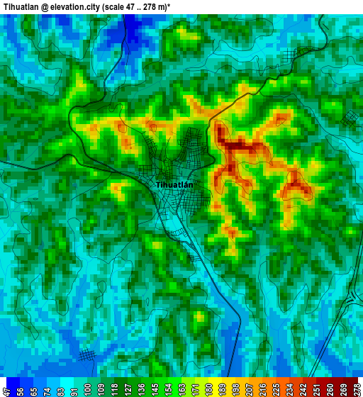
Below is the Elevation map of Tihuatlan, which displays elevation range with different colors. Scale of the first map is from 47 to 278 m (154 to 912 ft) with average elevation of 115.5 meters (=379 ft) [note 1]
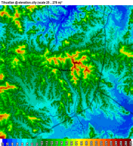
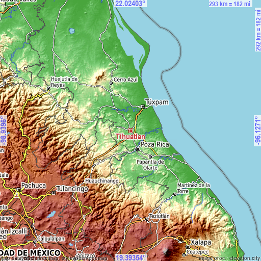
These maps also provides idea of topography and contour of this city, they are displayed at different zoom levels. More info about maps, scale and edge coordinates you can find below images.
| \ | Map #1 | Map #2 | Topo.Map |
| Scale [m] | 47..278 m | 25..278 m | × |
| Scale [ft] | 154..912 ft | 82..912 ft | × |
| Average | 115.5 m = 379 ft | 95.8 m = 314 ft | × |
| Width | 9.14 km = 5.7 mi | 18.28 km = 11.4 mi | 292.5 km = 181.8 mi |
| Height | 9.14 km = 5.7 mi | 18.28 km = 11.4 mi | 292.5 km = 181.8 mi |
| ↑Max Latitude | 20.755589° | 20.796677° | 22.02403° |
| Latitude at center | 20.71449° | 20.71449° | 20.71449° |
| ↓Min Latitude | 20.67338° | 20.632259° | 19.39354° |
| ← Min Longitude | -97.577295° | -97.621241° | -98.9396° |
| Longitude center | -97.53335° | -97.53335° | -97.53335° |
| →Max Longitude | -97.489405° | -97.445459° | -96.1271° |
Nearby cities:
Cities around Tihuatlan sort by population:
• Castillo de Teayo elevation 76 m
10.8 km,  290°
290°
• La Isla Km 10 76 m
12.5 km,  163°
163°
• Nuevo Progreso 92 m
11 km,  165°
165°
• Acontitla 21 m
15.9 km,  103°
103°
• Úrsulo Galván 47 m
15.8 km,  141°
141°
• La Concepción 31 m
15.6 km,  118°
118°
• Teayo 93 m
15.6 km,  282°
282°
• Residencial Tajín 35 m
17.7 km, 136°
• La Guadalupe 126 m
11.2 km,  260°
260°
• El Águila 93 m
12.3 km, 139°
• La Isla (Kilómetro 10) 102 m
12.3 km, 164°
• Buenos Aires (San Isidro) 60 m
15.7 km,  333°
333°
Multilingual:
 En español:
Tihuatlan elevación 98 m.
 En France:
Tihuatlan élévation 98 m.
 Auf Deutsch:
Tihuatlan höhe über dem Meeresspiegel ist 98 m.

Sources and notes:
- [note 1] Map square and city borders are not equal. Map elevation data is calculated only from area inside that square.
- [src 1] Elevation data from geonames database provided with same terms of usage.
- [src 2] The elevation map of Tihuatlan is generated using elevation data from NASA's 3 arcsec (90m) resolution SRTM data.
- [src 3] Base (background) map © OpenStreetMap contributors tiles are generated by Geofabrik and OpenTopoMap.
Copyright & License:
This Tihuatlan Elevation Map is licensed under CC BY-SA. You may reuse any part from this page, if you give a proper credit by linking to this URL:
 More info on terms of use page.