Residencial Tajín elevation
Residencial Tajín (Veracruz, Papantla), Mexico elevation is 35 meters and Residencial Tajín elevation in feet is 115 ft above sea level [src 1]. Residencial Tajín is a populated place (feature code) with elevation that is 1279 meters (4196 ft) smaller than average city elevation in Mexico.
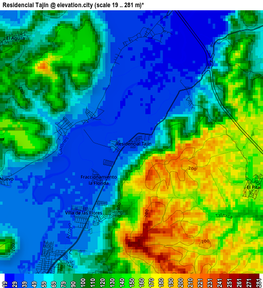
Below is the Elevation map of Residencial Tajín, which displays elevation range with different colors. Scale of the first map is from 19 to 281 m (62 to 922 ft) with average elevation of 98.8 meters (=324 ft) [note 1]
These maps also provides idea of topography and contour of this city, they are displayed at different zoom levels. More info about maps, scale and edge coordinates you can find below images.
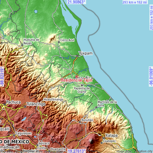
| \ | Map #1 | Topo.Map |
| Scale [m] | 19..281 m | × |
| Scale [ft] | 62..922 ft | × |
| Average | 98.8 m = 324 ft | × |
| Width | 9.15 km = 5.7 mi | 292.7 km = 181.9 mi |
| Height | 9.15 km = 5.7 mi | 292.7 km = 181.9 mi |
| ↑Max Latitude | 20.63919° | 21.90863° |
| Latitude at center | 20.59806° | 20.59806° |
| ↓Min Latitude | 20.556919° | 19.27613° |
| ← Min Longitude | -97.460885° | -98.82319° |
| Longitude center | -97.41694° | -97.41694° |
| →Max Longitude | -97.372995° | -96.01069° |
Nearby cities:
Cities around Residencial Tajín sort by population:
• Poza Rica de Hidalgo elevation 58 m
8.5 km,  211°
211°
• Plan de Ayala 49 m
7.9 km,  225°
225°
• Totolapa 51 m
7.6 km, 234°
• La Isla Km 10 76 m
8.6 km,  276°
276°
• Arroyo del Maíz Uno 111 m
6.8 km,  178°
178°
• Fraccionamiento la Florida 37 m
1.7 km,  223°
223°
• Villa de las Flores 39 m
3 km, 215°
• Úrsulo Galván 47 m
2.3 km, 283°
• La Concepción 31 m
5.8 km,  16°
16°
• Vicente Herrera 135 m
7.4 km,  108°
108°
• El Mollejon 122 m
6.2 km,  174°
174°
• El Águila 93 m
5.5 km,  311°
311°
Multilingual:
 En español:
Residencial Tajín elevación 35 m.
 En France:
Residencial Tajín élévation 35 m.
 Auf Deutsch:
Residencial Tajín höhe über dem Meeresspiegel ist 35 m.

Sources and notes:
- [note 1] Map square and city borders are not equal. Map elevation data is calculated only from area inside that square.
- [src 1] Elevation data from geonames database provided with same terms of usage.
- [src 2] The elevation map of Residencial Tajín is generated using elevation data from NASA's 3 arcsec (90m) resolution SRTM data.
- [src 3] Base (background) map © OpenStreetMap contributors tiles are generated by Geofabrik and OpenTopoMap.
Copyright & License:
This Residencial Tajín Elevation Map is licensed under CC BY-SA. You may reuse any part from this page, if you give a proper credit by linking to this URL:
 More info on terms of use page.