Plan de Ayala elevation
Plan de Ayala (Veracruz, Tihuatlán), Mexico elevation is 49 meters and Plan de Ayala elevation in feet is 161 ft above sea level [src 1]. Plan de Ayala is a populated place (feature code) with elevation that is 1265 meters (4150 ft) smaller than average city elevation in Mexico.
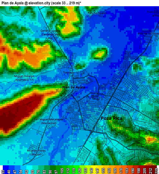
Below is the Elevation map of Plan de Ayala, which displays elevation range with different colors. Scale of the first map is from 33 to 219 m (108 to 719 ft) with average elevation of 76.3 meters (=250 ft) [note 1]
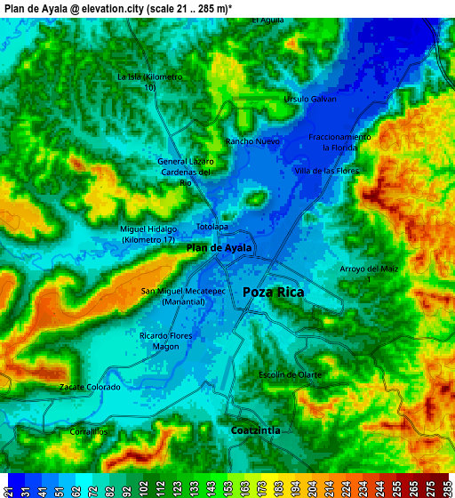
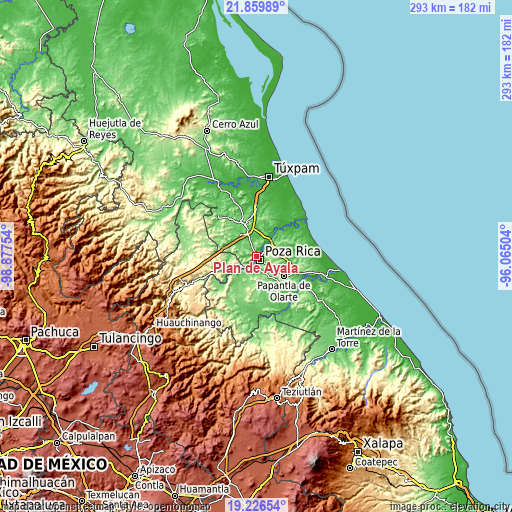
These maps also provides idea of topography and contour of this city, they are displayed at different zoom levels. More info about maps, scale and edge coordinates you can find below images.
| \ | Map #1 | Map #2 | Topo.Map |
| Scale [m] | 33..219 m | 21..285 m | × |
| Scale [ft] | 108..719 ft | 69..935 ft | × |
| Average | 76.3 m = 250 ft | 109.3 m = 359 ft | × |
| Width | 9.15 km = 5.7 mi | 18.3 km = 11.4 mi | 292.8 km = 181.9 mi |
| Height | 9.15 km = 5.7 mi | 18.3 km = 11.4 mi | 292.8 km = 181.9 mi |
| ↑Max Latitude | 20.590034° | 20.631166° | 21.85989° |
| Latitude at center | 20.54889° | 20.54889° | 20.54889° |
| ↓Min Latitude | 20.507735° | 20.466569° | 19.22654° |
| ← Min Longitude | -97.515235° | -97.559181° | -98.87754° |
| Longitude center | -97.47129° | -97.47129° | -97.47129° |
| →Max Longitude | -97.427345° | -97.383399° | -96.06504° |
Nearby cities:
Cities around Plan de Ayala sort by population:
• Poza Rica de Hidalgo elevation 58 m
2.1 km,  144°
144°
• Coatzintla 77 m
6.9 km,  177°
177°
• Totolapa 51 m
1.1 km,  332°
332°
• Arroyo del Maíz Uno 111 m
6 km,  103°
103°
• Ricardo Flores Magón 60 m
4.6 km,  212°
212°
• San Miguel Mecatepec 58 m
2.8 km,  217°
217°
• Emiliano Zapata 67 m
5.7 km,  269°
269°
• Fraccionamiento la Florida 37 m
6.1 km,  46°
46°
• Villa de las Flores 39 m
5 km, 52°
• Úrsulo Galván 47 m
6.9 km,  29°
29°
• El Mollejon 122 m
6.3 km, 96°
• Miguel Hidalgo 67 m
3.2 km,  278°
278°
Multilingual:
 En español:
Plan de Ayala elevación 49 m.
 En France:
Plan de Ayala élévation 49 m.
 Auf Deutsch:
Plan de Ayala höhe über dem Meeresspiegel ist 49 m.

Sources and notes:
- [note 1] Map square and city borders are not equal. Map elevation data is calculated only from area inside that square.
- [src 1] Elevation data from geonames database provided with same terms of usage.
- [src 2] The elevation map of Plan de Ayala is generated using elevation data from NASA's 3 arcsec (90m) resolution SRTM data.
- [src 3] Base (background) map © OpenStreetMap contributors tiles are generated by Geofabrik and OpenTopoMap.
Copyright & License:
This Plan de Ayala Elevation Map is licensed under CC BY-SA. You may reuse any part from this page, if you give a proper credit by linking to this URL:
 More info on terms of use page.