Castillo de Teayo elevation
Castillo de Teayo (Veracruz), Mexico elevation is 76 meters and Castillo de Teayo elevation in feet is 249 ft above sea level [src 1]. Castillo de Teayo is a seat of a second-order administrative division (feature code) with elevation that is 1238 meters (4062 ft) smaller than average city elevation in Mexico.
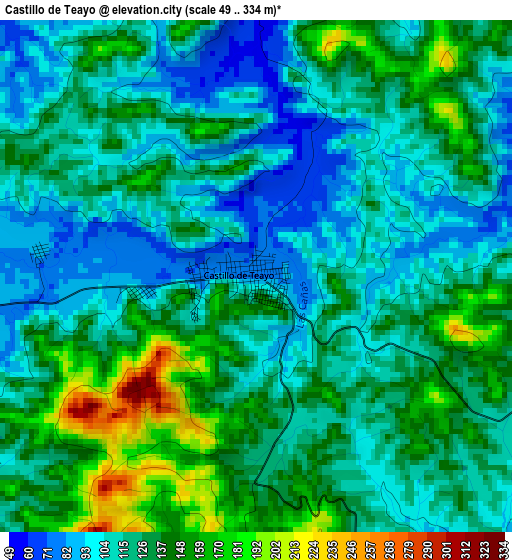
Below is the Elevation map of Castillo de Teayo, which displays elevation range with different colors. Scale of the first map is from 49 to 334 m (161 to 1096 ft) with average elevation of 123.9 meters (=406 ft) [note 1]
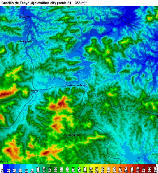
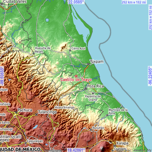
These maps also provides idea of topography and contour of this city, they are displayed at different zoom levels. More info about maps, scale and edge coordinates you can find below images.
| \ | Map #1 | Map #2 | Topo.Map |
| Scale [m] | 49..334 m | 31..356 m | × |
| Scale [ft] | 161..1096 ft | 102..1168 ft | × |
| Average | 123.9 m = 406 ft | 114.9 m = 377 ft | × |
| Width | 9.14 km = 5.7 mi | 18.28 km = 11.4 mi | 292.4 km = 181.7 mi |
| Height | 9.14 km = 5.7 mi | 18.28 km = 11.4 mi | 292.4 km = 181.7 mi |
| ↑Max Latitude | 20.790359° | 20.831438° | 22.0585° |
| Latitude at center | 20.74927° | 20.74927° | 20.74927° |
| ↓Min Latitude | 20.708169° | 20.667058° | 19.42861° |
| ← Min Longitude | -97.674245° | -97.718191° | -99.03655° |
| Longitude center | -97.6303° | -97.6303° | -97.6303° |
| →Max Longitude | -97.586355° | -97.542409° | -96.22405° |
Nearby cities:
Cities around Castillo de Teayo sort by population:
• Álamo elevation 23 m
18.6 km,  345°
345°
• Tihuatlan 98 m
10.8 km,  110°
110°
• Estero del Ídolo 26 m
15.9 km, 349°
• Mequetla 59 m
7.9 km,  309°
309°
• Emiliano Zapata 59 m
15.8 km,  323°
323°
• Teayo 93 m
5.2 km,  263°
263°
• La Unión 28 m
16.3 km, 347°
• La Guadalupe 126 m
5.7 km,  189°
189°
• Hidalgo Amajac 18 m
17.3 km,  0°
0°
• Tincontlán 51 m
10.2 km, 321°
• La Concepción 38 m
13.7 km,  337°
337°
• Buenos Aires (San Isidro) 60 m
10.6 km,  16°
16°
Multilingual:
 En español:
Castillo de Teayo elevación 76 m.
 En France:
Castillo de Teayo élévation 76 m.
 Auf Deutsch:
Castillo de Teayo höhe über dem Meeresspiegel ist 76 m.

Sources and notes:
- [note 1] Map square and city borders are not equal. Map elevation data is calculated only from area inside that square.
- [src 1] Elevation data from geonames database provided with same terms of usage.
- [src 2] The elevation map of Castillo de Teayo is generated using elevation data from NASA's 3 arcsec (90m) resolution SRTM data.
- [src 3] Base (background) map © OpenStreetMap contributors tiles are generated by Geofabrik and OpenTopoMap.
Copyright & License:
This Castillo de Teayo Elevation Map is licensed under CC BY-SA. You may reuse any part from this page, if you give a proper credit by linking to this URL:
 More info on terms of use page.