Tlamacazapa elevation
Tlamacazapa (Guerrero, Taxco de Alarcón), Mexico elevation is 1952 meters and Tlamacazapa elevation in feet is 6404 ft above sea level [src 1]. Tlamacazapa is a populated place (feature code) with elevation that is 638 meters (2093 ft) bigger than average city elevation in Mexico.
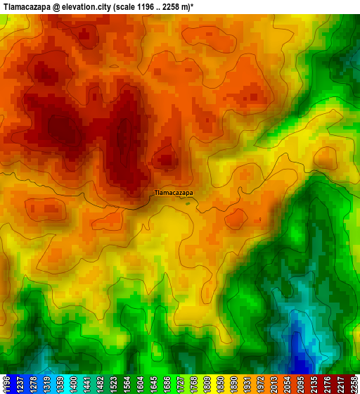
Below is the Elevation map of Tlamacazapa, which displays elevation range with different colors. Scale of the first map is from 1196 to 2258 m (3924 to 7408 ft) with average elevation of 1854.6 meters (=6085 ft) [note 1]
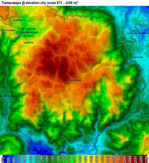
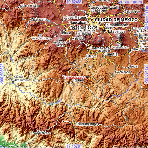
These maps also provides idea of topography and contour of this city, they are displayed at different zoom levels. More info about maps, scale and edge coordinates you can find below images.
| \ | Map #1 | Map #2 | Topo.Map |
| Scale [m] | 1196..2258 m | 873..2258 m | × |
| Scale [ft] | 3924..7408 ft | 2864..7408 ft | × |
| Average | 1854.6 m = 6085 ft | 1553.9 m = 5098 ft | × |
| Width | 9.27 km = 5.8 mi | 18.54 km = 11.5 mi | 296.5 km = 184.2 mi |
| Height | 9.27 km = 5.8 mi | 18.54 km = 11.5 mi | 296.6 km = 184.3 mi |
| ↑Max Latitude | 18.53816° | 18.57982° | 19.8248° |
| Latitude at center | 18.49649° | 18.49649° | 18.49649° |
| ↓Min Latitude | 18.45481° | 18.413119° | 17.1578° |
| ← Min Longitude | -99.544315° | -99.588261° | -100.90662° |
| Longitude center | -99.50037° | -99.50037° | -99.50037° |
| →Max Longitude | -99.456425° | -99.412479° | -98.09412° |
Nearby cities:
Cities around Tlamacazapa sort by population:
• Taxco de Alarcón elevation 1770 m
12.9 km,  300°
300°
• Buenavista de Cuéllar 1255 m
10.5 km,  112°
112°
• Acamixtla 1594 m
10.3 km,  317°
317°
• Acuitlapan 1579 m
12.5 km,  339°
339°
• Taxco el Viejo 1276 m
9 km,  260°
260°
• Tehuilotepec 1694 m
10.5 km,  305°
305°
• Casahuatlán 985 m
14.4 km,  53°
53°
• Axixintla 1222 m
11.9 km,  350°
350°
• Santa Fe Tepetlapa 1056 m
9.9 km, 53°
• San Juan de Dios (Naranjas de Dios) 1499 m
8.3 km, 315°
• Tecalpulco 1415 m
10.8 km,  265°
265°
• Palmillas 1112 m
8.4 km,  70°
70°
Multilingual:
 En español:
Tlamacazapa elevación 1952 m.
 En France:
Tlamacazapa élévation 1952 m.
 Auf Deutsch:
Tlamacazapa höhe über dem Meeresspiegel ist 1952 m.

Sources and notes:
- [note 1] Map square and city borders are not equal. Map elevation data is calculated only from area inside that square.
- [src 1] Elevation data from geonames database provided with same terms of usage.
- [src 2] The elevation map of Tlamacazapa is generated using elevation data from NASA's 3 arcsec (90m) resolution SRTM data.
- [src 3] Base (background) map © OpenStreetMap contributors tiles are generated by Geofabrik and OpenTopoMap.
Copyright & License:
This Tlamacazapa Elevation Map is licensed under CC BY-SA. You may reuse any part from this page, if you give a proper credit by linking to this URL:
 More info on terms of use page.