Totutla elevation
Totutla (Veracruz), Mexico elevation is 1449 meters and Totutla elevation in feet is 4754 ft above sea level [src 1]. Totutla is a seat of a second-order administrative division (feature code) with elevation that is 135 meters (443 ft) bigger than average city elevation in Mexico.
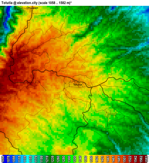
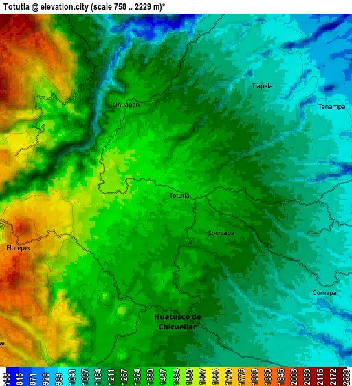
Below is the Elevation map of Totutla, which displays elevation range with different colors. Scale of the first map is from 1058 to 1582 m (3471 to 5190 ft) with average elevation of 1344.1 meters (=4410 ft) [note 1]
These maps also provides idea of topography and contour of this city, they are displayed at different zoom levels. More info about maps, scale and edge coordinates you can find below images.
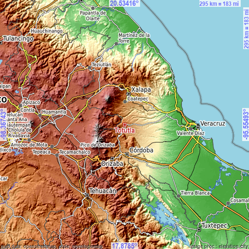
| \ | Map #1 | Map #2 | Topo.Map |
| Scale [m] | 1058..1582 m | 758..2229 m | × |
| Scale [ft] | 3471..5190 ft | 2487..7313 ft | × |
| Average | 1344.1 m = 4410 ft | 1306.6 m = 4287 ft | × |
| Width | 9.23 km = 5.7 mi | 18.46 km = 11.5 mi | 295.3 km = 183.5 mi |
| Height | 9.23 km = 5.7 mi | 18.46 km = 11.5 mi | 295.3 km = 183.5 mi |
| ↑Max Latitude | 19.253183° | 19.294665° | 20.53416° |
| Latitude at center | 19.21169° | 19.21169° | 19.21169° |
| ↓Min Latitude | 19.170187° | 19.128673° | 17.8785° |
| ← Min Longitude | -97.005125° | -97.049071° | -98.36743° |
| Longitude center | -96.96118° | -96.96118° | -96.96118° |
| →Max Longitude | -96.917235° | -96.873289° | -95.55493° |
Nearby cities:
Cities around Totutla sort by population:
• Huatusco elevation 1290 m
7 km,  185°
185°
• Chichiquila 1786 m
11.2 km,  263°
263°
• Tenampa 1021 m
9.1 km,  63°
63°
• Elotepec 1849 m
8.4 km,  251°
251°
• Ohuapan 1407 m
5.1 km,  328°
328°
• Mata Obscura 950 m
11.2 km,  86°
86°
• Ixpila 1133 m
10.4 km,  183°
183°
• Comapa 1066 m
9.5 km,  124°
124°
• Tlapala 1104 m
7.1 km,  38°
38°
• Coyolito 996 m
9.7 km,  79°
79°
• Sochiapa 1340 m
3.1 km,  133°
133°
• Nenehuaca 1841 m
11.4 km,  228°
228°
Multilingual:
 En español:
Totutla elevación 1449 m.
 En France:
Totutla élévation 1449 m.
 Auf Deutsch:
Totutla höhe über dem Meeresspiegel ist 1449 m.

Sources and notes:
- [note 1] Map square and city borders are not equal. Map elevation data is calculated only from area inside that square.
- [src 1] Elevation data from geonames database provided with same terms of usage.
- [src 2] The elevation map of Totutla is generated using elevation data from NASA's 3 arcsec (90m) resolution SRTM data.
- [src 3] Base (background) map © OpenStreetMap contributors tiles are generated by Geofabrik and OpenTopoMap.
Copyright & License:
This Totutla Elevation Map is licensed under CC BY-SA. You may reuse any part from this page, if you give a proper credit by linking to this URL:
 More info on terms of use page.