Xicotepec de Juárez elevation
Xicotepec de Juárez (Puebla, Xicotepec), Mexico elevation is 1167 meters and Xicotepec de Juárez elevation in feet is 3829 ft above sea level [src 1]. Xicotepec de Juárez is a populated place (feature code) with elevation that is 147 meters (482 ft) smaller than average city elevation in Mexico.
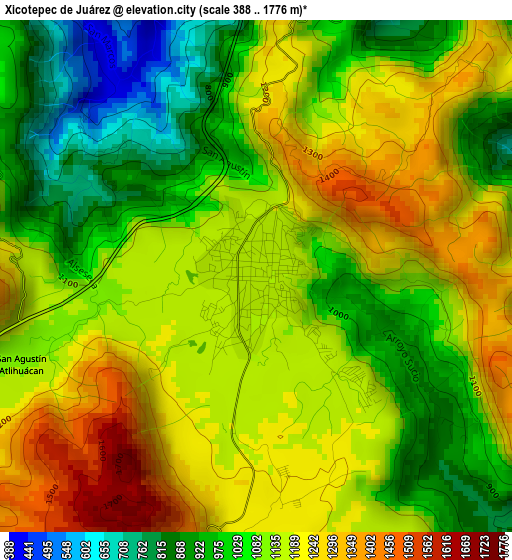
Below is the Elevation map of Xicotepec de Juárez, which displays elevation range with different colors. Scale of the first map is from 388 to 1776 m (1273 to 5827 ft) with average elevation of 1114.1 meters (=3655 ft) [note 1]
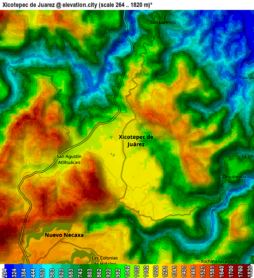
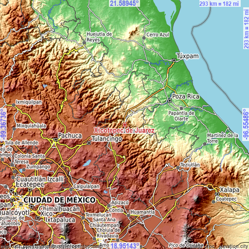
These maps also provides idea of topography and contour of this city, they are displayed at different zoom levels. More info about maps, scale and edge coordinates you can find below images.
| \ | Map #1 | Map #2 | Topo.Map |
| Scale [m] | 388..1776 m | 264..1820 m | × |
| Scale [ft] | 1273..5827 ft | 866..5971 ft | × |
| Average | 1114.1 m = 3655 ft | 1002.2 m = 3288 ft | × |
| Width | 9.17 km = 5.7 mi | 18.33 km = 11.4 mi | 293.3 km = 182.2 mi |
| Height | 9.17 km = 5.7 mi | 18.33 km = 11.4 mi | 293.3 km = 182.2 mi |
| ↑Max Latitude | 20.317267° | 20.358472° | 21.58945° |
| Latitude at center | 20.27605° | 20.27605° | 20.27605° |
| ↓Min Latitude | 20.234822° | 20.193584° | 18.95143° |
| ← Min Longitude | -98.005055° | -98.049001° | -99.36736° |
| Longitude center | -97.96111° | -97.96111° | -97.96111° |
| →Max Longitude | -97.917165° | -97.873219° | -96.55486° |
Nearby cities:
Cities around Xicotepec de Juárez sort by population:
• Necaxa elevation 1353 m
8.8 km,  216°
216°
• Nuevo Necaxa 1354 m
8.7 km,  213°
213°
• Tenango de las Flores 1305 m
8.3 km,  199°
199°
• Las Colonias de Hidalgo 1284 m
9 km,  190°
190°
• Tlaxcalantongo 661 m
10.2 km,  65°
65°
• La Unión 661 m
9.5 km,  99°
99°
• Zihuateutla 982 m
8.2 km,  110°
110°
• Ahuaxintitla 733 m
7.3 km, 110°
• San Lorenzo 821 m
8.7 km,  17°
17°
• San Antonio Ocopetlatlán 1197 m
3.6 km,  154°
154°
• San Pedro Itztla 1109 m
2.8 km,  93°
93°
• Tierra Negra 1206 m
3.7 km,  172°
172°
Multilingual:
 En español:
Xicotepec de Juárez elevación 1167 m.
 En France:
Xicotepec de Juárez élévation 1167 m.
 Auf Deutsch:
Xicotepec de Juárez höhe über dem Meeresspiegel ist 1167 m.
 На русском:
Xicotepec de Juárez высота над уровнем моря 1167 м
Sources and notes:
- [note 1] Map square and city borders are not equal. Map elevation data is calculated only from area inside that square.
- [src 1] Elevation data from geonames database provided with same terms of usage.
- [src 2] The elevation map of Xicotepec de Juárez is generated using elevation data from NASA's 3 arcsec (90m) resolution SRTM data.
- [src 3] Base (background) map © OpenStreetMap contributors tiles are generated by Geofabrik and OpenTopoMap.
Copyright & License:
This Xicotepec de Juárez Elevation Map is licensed under CC BY-SA. You may reuse any part from this page, if you give a proper credit by linking to this URL:
 More info on terms of use page.