Tlaxcalantongo elevation
Tlaxcalantongo (Puebla, Xicotepec), Mexico elevation is 661 meters and Tlaxcalantongo elevation in feet is 2169 ft above sea level [src 1]. Tlaxcalantongo is a populated place (feature code) with elevation that is 653 meters (2142 ft) smaller than average city elevation in Mexico.
Below is the Elevation map of Tlaxcalantongo, which displays elevation range with different colors. Scale of the first map is from 267 to 1381 m (876 to 4531 ft) with average elevation of 600.3 meters (=1969 ft) [note 1]
These maps also provides idea of topography and contour of this city, they are displayed at different zoom levels. More info about maps, scale and edge coordinates you can find below images.
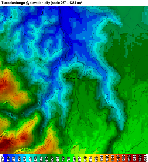
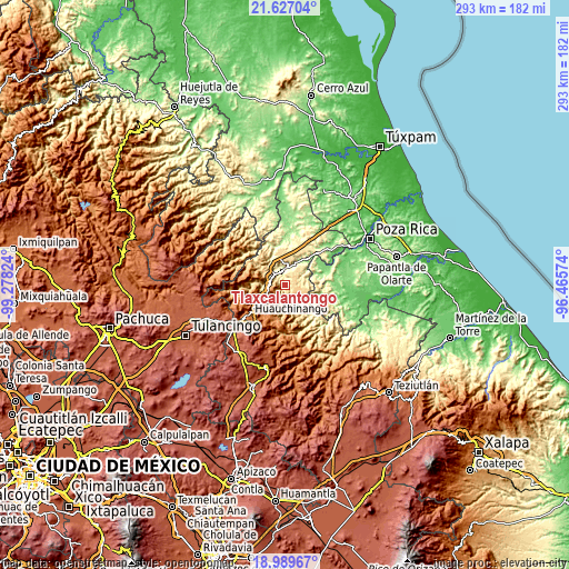
| \ | Map #1 | Topo.Map |
| Scale [m] | 267..1381 m | × |
| Scale [ft] | 876..4531 ft | × |
| Average | 600.3 m = 1969 ft | × |
| Width | 9.16 km = 5.7 mi | 293.2 km = 182.2 mi |
| Height | 9.16 km = 5.7 mi | 293.3 km = 182.2 mi |
| ↑Max Latitude | 20.355177° | 21.62704° |
| Latitude at center | 20.31397° | 20.31397° |
| ↓Min Latitude | 20.272752° | 18.98967° |
| ← Min Longitude | -97.915935° | -99.27824° |
| Longitude center | -97.87199° | -97.87199° |
| →Max Longitude | -97.828045° | -96.46574° |
Nearby cities:
Cities around Tlaxcalantongo sort by population:
• Xicotepec de Juárez elevation 1167 m
10.2 km,  245°
245°
• Villa Avila Camacho 244 m
8 km,  354°
354°
• Chicontla 325 m
8.9 km,  150°
150°
• Apapantilla 231 m
10.3 km,  14°
14°
• Gilberto Camacho 253 m
6.8 km, 348°
• La Unión 661 m
5.8 km,  179°
179°
• Santa Rita 555 m
8 km,  45°
45°
• Zihuateutla 982 m
7.2 km,  193°
193°
• Ahuaxintitla 733 m
7.2 km,  200°
200°
• San Lorenzo 821 m
7.8 km,  301°
301°
• San Pedro Itztla 1109 m
7.8 km,  236°
236°
• Patla 355 m
7.6 km,  164°
164°
Multilingual:
 En español:
Tlaxcalantongo elevación 661 m.
 En France:
Tlaxcalantongo élévation 661 m.
 Auf Deutsch:
Tlaxcalantongo höhe über dem Meeresspiegel ist 661 m.

Sources and notes:
- [note 1] Map square and city borders are not equal. Map elevation data is calculated only from area inside that square.
- [src 1] Elevation data from geonames database provided with same terms of usage.
- [src 2] The elevation map of Tlaxcalantongo is generated using elevation data from NASA's 3 arcsec (90m) resolution SRTM data.
- [src 3] Base (background) map © OpenStreetMap contributors tiles are generated by Geofabrik and OpenTopoMap.
Copyright & License:
This Tlaxcalantongo Elevation Map is licensed under CC BY-SA. You may reuse any part from this page, if you give a proper credit by linking to this URL:
 More info on terms of use page.