Zapotitlán elevation
Zapotitlán (Puebla), Mexico elevation is 1487 meters and Zapotitlán elevation in feet is 4879 ft above sea level [src 1]. Zapotitlán is a seat of a second-order administrative division (feature code) with elevation that is 173 meters (568 ft) bigger than average city elevation in Mexico.
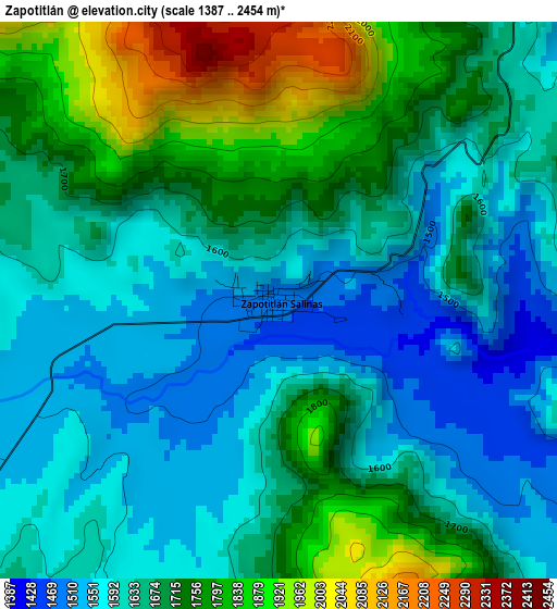
Below is the Elevation map of Zapotitlán, which displays elevation range with different colors. Scale of the first map is from 1387 to 2454 m (4551 to 8051 ft) with average elevation of 1672.1 meters (=5486 ft) [note 1]
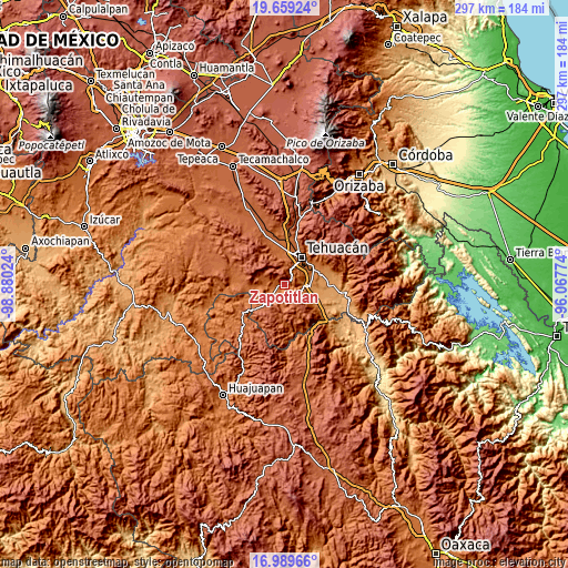
These maps also provides idea of topography and contour of this city, they are displayed at different zoom levels. More info about maps, scale and edge coordinates you can find below images.
| \ | Map #1 | Topo.Map |
| Scale [m] | 1387..2454 m | × |
| Scale [ft] | 4551..8051 ft | × |
| Average | 1672.1 m = 5486 ft | × |
| Width | 9.28 km = 5.8 mi | 296.8 km = 184.4 mi |
| Height | 9.28 km = 5.8 mi | 296.9 km = 184.5 mi |
| ↑Max Latitude | 18.371311° | 19.65924° |
| Latitude at center | 18.3296° | 18.3296° |
| ↓Min Latitude | 18.287879° | 16.98966° |
| ← Min Longitude | -97.517935° | -98.88024° |
| Longitude center | -97.47399° | -97.47399° |
| →Max Longitude | -97.430045° | -96.06774° |
Nearby cities:
Cities around Zapotitlán sort by population:
• Tehuacán elevation 1643 m
17 km,  28°
28°
• Altepexi 1238 m
18.9 km,  76°
76°
• San Gabriel Chilac 1232 m
13.4 km,  91°
91°
• Necoxtla 1430 m
14.2 km,  57°
57°
• San José Monte Chiquito 1690 m
18.9 km,  11°
11°
• San Juan Atzingo 1440 m
9.9 km,  110°
110°
• Tepetzingo 1401 m
17.7 km,  54°
54°
• Francisco Ignacio Madero 1705 m
18.2 km,  3°
3°
• Santa Cruz Acapa 1345 m
17.7 km, 61°
• Texcala 1686 m
8.1 km,  22°
22°
• Teloxtoc 1880 m
12.5 km,  296°
296°
• San Pedro Tetitlán 1183 m
17.7 km,  115°
115°
Multilingual:
 En español:
Zapotitlán elevación 1487 m.
 En France:
Zapotitlán élévation 1487 m.
 Auf Deutsch:
Zapotitlán höhe über dem Meeresspiegel ist 1487 m.

Sources and notes:
- [note 1] Map square and city borders are not equal. Map elevation data is calculated only from area inside that square.
- [src 1] Elevation data from geonames database provided with same terms of usage.
- [src 2] The elevation map of Zapotitlán is generated using elevation data from NASA's 3 arcsec (90m) resolution SRTM data.
- [src 3] Base (background) map © OpenStreetMap contributors tiles are generated by Geofabrik and OpenTopoMap.
Copyright & License:
This Zapotitlán Elevation Map is licensed under CC BY-SA. You may reuse any part from this page, if you give a proper credit by linking to this URL:
 More info on terms of use page.