Altepexi elevation
Altepexi (Puebla), Mexico elevation is 1238 meters and Altepexi elevation in feet is 4062 ft above sea level [src 1]. Altepexi is a seat of a second-order administrative division (feature code) with elevation that is 76 meters (249 ft) smaller than average city elevation in Mexico.
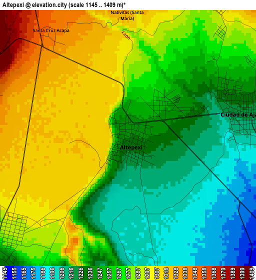
Below is the Elevation map of Altepexi, which displays elevation range with different colors. Scale of the first map is from 1145 to 1409 m (3757 to 4623 ft) with average elevation of 1264.9 meters (=4150 ft) [note 1]
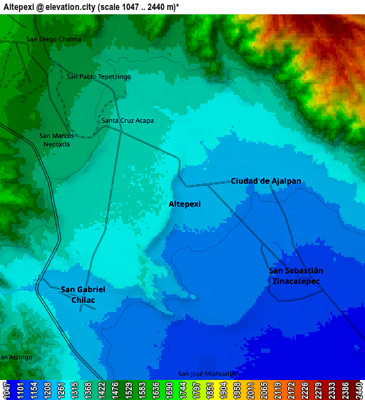
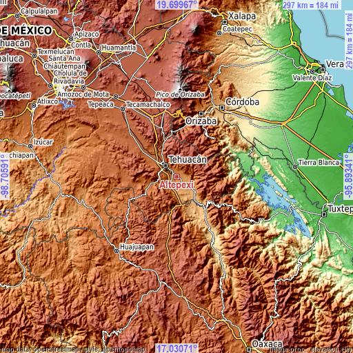
These maps also provides idea of topography and contour of this city, they are displayed at different zoom levels. More info about maps, scale and edge coordinates you can find below images.
| \ | Map #1 | Map #2 | Topo.Map |
| Scale [m] | 1145..1409 m | 1047..2440 m | × |
| Scale [ft] | 3757..4623 ft | 3435..8005 ft | × |
| Average | 1264.9 m = 4150 ft | 1350.8 m = 4432 ft | × |
| Width | 9.27 km = 5.8 mi | 18.55 km = 11.5 mi | 296.8 km = 184.4 mi |
| Height | 9.27 km = 5.8 mi | 18.55 km = 11.5 mi | 296.8 km = 184.4 mi |
| ↑Max Latitude | 18.412051° | 18.453741° | 19.69967° |
| Latitude at center | 18.37035° | 18.37035° | 18.37035° |
| ↓Min Latitude | 18.328639° | 18.286918° | 17.03071° |
| ← Min Longitude | -97.343605° | -97.387551° | -98.70591° |
| Longitude center | -97.29966° | -97.29966° | -97.29966° |
| →Max Longitude | -97.255715° | -97.211769° | -95.89341° |
Nearby cities:
Cities around Altepexi sort by population:
• Ajalpan elevation 1223 m
4.4 km,  77°
77°
• Zinacatepec 1145 m
6.9 km,  124°
124°
• San Gabriel Chilac 1232 m
7 km,  225°
225°
• Miahuatlán 1121 m
8.8 km,  171°
171°
• Necoxtla 1430 m
7.1 km,  295°
295°
• San Juan Atzingo 1440 m
12.1 km, 228°
• Tepetzingo 1401 m
7 km,  324°
324°
• Santa Cruz Acapa 1345 m
4.8 km, 324°
• Necoxcalco 1530 m
10.1 km,  0°
0°
• San Pedro Tetitlán 1183 m
12.5 km,  191°
191°
• San Jerónimo Axochitlán 1081 m
10.9 km,  159°
159°
• San José Buena Vista 1289 m
5.1 km,  40°
40°
Multilingual:
 En español:
San Francisco Altepexi elevación 1238 m.
 En France:
Altepexi élévation 1238 m.
 Auf Deutsch:
Altepexi höhe über dem Meeresspiegel ist 1238 m.

Sources and notes:
- [note 1] Map square and city borders are not equal. Map elevation data is calculated only from area inside that square.
- [src 1] Elevation data from geonames database provided with same terms of usage.
- [src 2] The elevation map of Altepexi is generated using elevation data from NASA's 3 arcsec (90m) resolution SRTM data.
- [src 3] Base (background) map © OpenStreetMap contributors tiles are generated by Geofabrik and OpenTopoMap.
Copyright & License:
This Altepexi Elevation Map is licensed under CC BY-SA. You may reuse any part from this page, if you give a proper credit by linking to this URL:
 More info on terms of use page.