Bayanbaraat elevation
Bayanbaraat (Central Aimak), Mongolia elevation is 1501 meters and Bayanbaraat elevation in feet is 4925 ft above sea level [src 1]. Bayanbaraat is a seat of a second-order administrative division (feature code) with elevation that is 88 meters (289 ft) bigger than average city elevation in Mongolia.
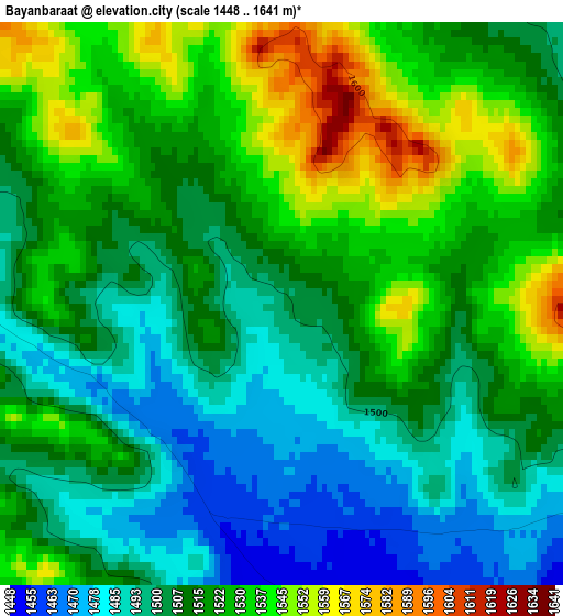
Below is the Elevation map of Bayanbaraat, which displays elevation range with different colors. Scale of the first map is from 1448 to 1641 m (4751 to 5384 ft) with average elevation of 1514.9 meters (=4970 ft) [note 1]
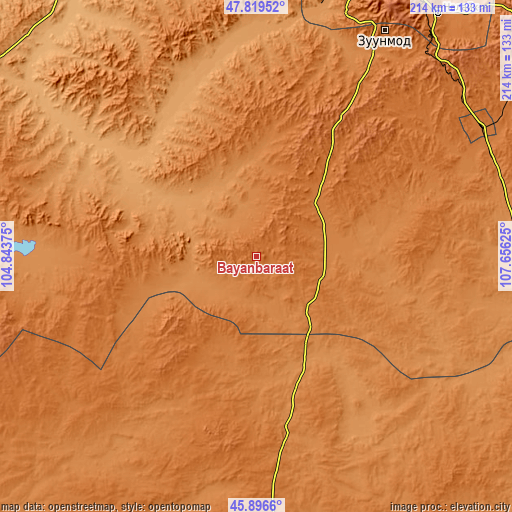
These maps also provides idea of topography and contour of this city, they are displayed at different zoom levels. More info about maps, scale and edge coordinates you can find below images.
| \ | Map #1 | Topo.Map |
| Scale [m] | 1448..1641 m | × |
| Scale [ft] | 4751..5384 ft | × |
| Average | 1514.9 m = 4970 ft | × |
| Width | 6.68 km = 4.2 mi | 213.8 km = 132.8 mi |
| Height | 6.68 km = 4.2 mi | 213.8 km = 132.8 mi |
| ↑Max Latitude | 46.896707° | 47.81952° |
| Latitude at center | 46.86667° | 46.86667° |
| ↓Min Latitude | 46.836616° | 45.8966° |
| ← Min Longitude | 106.206055° | 104.84375° |
| Longitude center | 106.25° | 106.25° |
| →Max Longitude | 106.293945° | 107.65625° |
Nearby cities:
Cities around Bayanbaraat sort by population:
• Зуунмод elevation 1514 m
107.4 km,  29°
29°
• Dzuunmod 1514 m
107.4 km, 29°
• Argalant 1225 m
122.5 km,  347°
347°
• Haraat 1381 m
118 km,  115°
115°
• Maanĭt 1413 m
106.1 km,  66°
66°
• Höshigiyn-Ar 1588 m
93.8 km,  35°
35°
• Altanbulag 1210 m
93.3 km,  6°
6°
• Bayantöhöm 1275 m
91.4 km,  273°
273°
• Tsant 1312 m
83.9 km,  154°
154°
• Amardalay 1400 m
82.9 km,  173°
173°
• Dzogsool 1381 m
68.9 km,  96°
96°
• Tavin 1482 m
65.8 km,  216°
216°
Multilingual:
 En español:
Bayanbaraat elevación 1501 m.
 En France:
Bayanbaraat élévation 1501 m.
 Auf Deutsch:
Bayanbaraat höhe über dem Meeresspiegel ist 1501 m.

Sources and notes:
- [note 1] Map square and city borders are not equal. Map elevation data is calculated only from area inside that square.
- [src 1] Elevation data from geonames database provided with same terms of usage.
- [src 2] The elevation map of Bayanbaraat is generated using elevation data from NASA's 3 arcsec (90m) resolution SRTM data.
- [src 3] Base (background) map © OpenStreetMap contributors tiles are generated by Geofabrik and OpenTopoMap.
Copyright & License:
This Bayanbaraat Elevation Map is licensed under CC BY-SA. You may reuse any part from this page, if you give a proper credit by linking to this URL:
 More info on terms of use page.