Haraat elevation
Haraat (Middle Govĭ), Mongolia elevation is 1381 meters and Haraat elevation in feet is 4531 ft above sea level [src 1]. Haraat is a seat of a second-order administrative division (feature code) with elevation that is 32 meters (105 ft) smaller than average city elevation in Mongolia.
Below is the Elevation map of Haraat, which displays elevation range with different colors. Scale of the first map is from 1287 to 1414 m (4222 to 4639 ft) with average elevation of 1353.7 meters (=4441 ft) [note 1]
These maps also provides idea of topography and contour of this city, they are displayed at different zoom levels. More info about maps, scale and edge coordinates you can find below images.
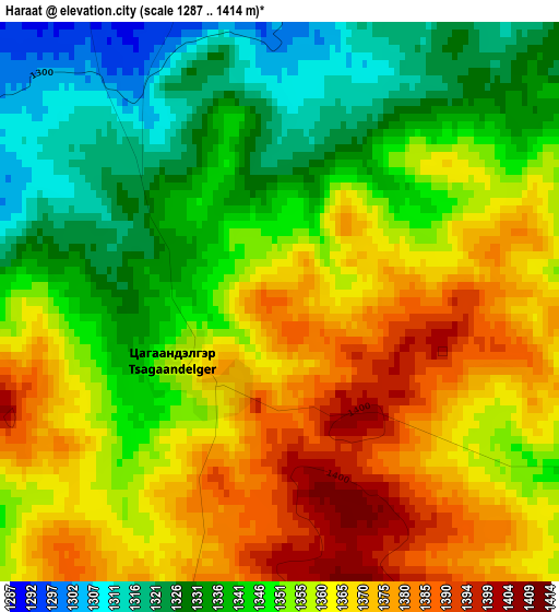
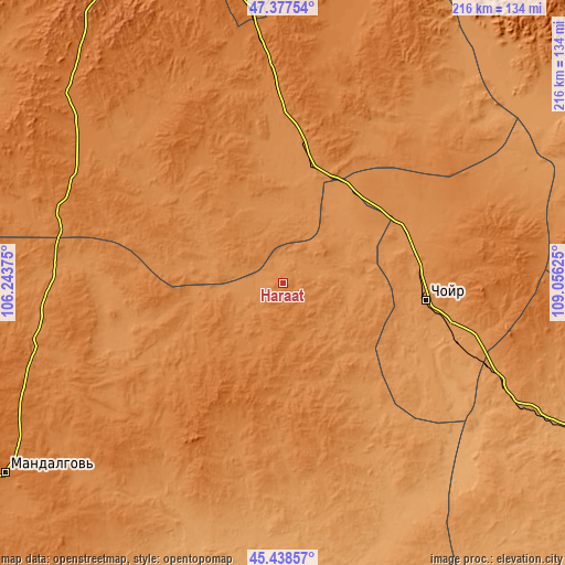
| \ | Map #1 | Topo.Map |
| Scale [m] | 1287..1414 m | × |
| Scale [ft] | 4222..4639 ft | × |
| Average | 1353.7 m = 4441 ft | × |
| Width | 6.74 km = 4.2 mi | 215.6 km = 134 mi |
| Height | 6.74 km = 4.2 mi | 215.6 km = 134 mi |
| ↑Max Latitude | 46.446958° | 47.37754° |
| Latitude at center | 46.41667° | 46.41667° |
| ↓Min Latitude | 46.386365° | 45.43857° |
| ← Min Longitude | 107.606055° | 106.24375° |
| Longitude center | 107.65° | 107.65° |
| →Max Longitude | 107.693945° | 109.05625° |
Nearby cities:
Cities around Haraat sort by population:
• Choyr elevation 1286 m
54.9 km,  96°
96°
• Bayanbaraat 1501 m
118 km,  295°
295°
• Suugaant 1169 m
108.8 km,  205°
205°
• Amardalay 1400 m
103.2 km,  251°
251°
• Bayasgalant 1376 m
96.7 km,  28°
28°
• Maanĭt 1413 m
93.1 km,  354°
354°
• Shiveegovĭ 1179 m
82.2 km,  114°
114°
• Argatay 1261 m
76.7 km,  160°
160°
• Tsant 1312 m
76.2 km, 250°
• Dzogsool 1381 m
57.2 km,  318°
318°
• Bayantal 1277 m
52.6 km,  72°
72°
• Hajuu-Us 1457 m
42.6 km,  196°
196°
Multilingual:
 En español:
Haraat elevación 1381 m.
 En France:
Haraat élévation 1381 m.


Sources and notes:
- [note 1] Map square and city borders are not equal. Map elevation data is calculated only from area inside that square.
- [src 1] Elevation data from geonames database provided with same terms of usage.
- [src 2] The elevation map of Haraat is generated using elevation data from NASA's 3 arcsec (90m) resolution SRTM data.
- [src 3] Base (background) map © OpenStreetMap contributors tiles are generated by Geofabrik and OpenTopoMap.
Copyright & License:
This Haraat Elevation Map is licensed under CC BY-SA. You may reuse any part from this page, if you give a proper credit by linking to this URL:
 More info on terms of use page.