Argalant elevation
Argalant (Central Aimak), Mongolia elevation is 1225 meters and Argalant elevation in feet is 4019 ft above sea level [src 1]. Argalant is a seat of a second-order administrative division (feature code) with elevation that is 188 meters (617 ft) smaller than average city elevation in Mongolia.
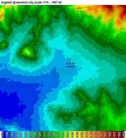
Below is the Elevation map of Argalant, which displays elevation range with different colors. Scale of the first map is from 1174 to 1567 m (3852 to 5141 ft) with average elevation of 1277.1 meters (=4190 ft) [note 1]
These maps also provides idea of topography and contour of this city, they are displayed at different zoom levels. More info about maps, scale and edge coordinates you can find below images.
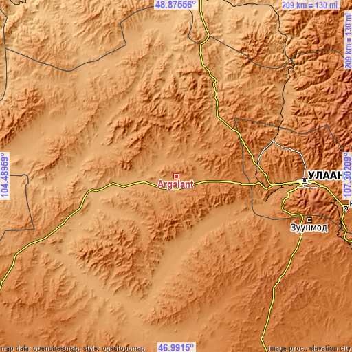
| \ | Map #1 | Topo.Map |
| Scale [m] | 1174..1567 m | × |
| Scale [ft] | 3852..5141 ft | × |
| Average | 1277.1 m = 4190 ft | × |
| Width | 6.55 km = 4.1 mi | 209.5 km = 130.2 mi |
| Height | 6.55 km = 4.1 mi | 209.5 km = 130.2 mi |
| ↑Max Latitude | 47.97154° | 48.87556° |
| Latitude at center | 47.94211° | 47.94211° |
| ↓Min Latitude | 47.912663° | 46.9915° |
| ← Min Longitude | 105.851895° | 104.48959° |
| Longitude center | 105.89584° | 105.89584° |
| →Max Longitude | 105.939785° | 107.30209° |
Nearby cities:
Cities around Argalant sort by population:
• Ulan Bator elevation 1284 m
73.7 km,  92°
92°
• Dzuunmod 1514 m
83.1 km,  108°
108°
• Mandal 1127 m
78.7 km,  52°
52°
• Orgil 1055 m
71.2 km,  323°
323°
• Bornuur 1007 m
64.5 km,  25°
25°
• Jargalant 991 m
64.3 km,  358°
358°
• Ar-Asgat 1169 m
50.6 km,  314°
314°
• Sujji 1009 m
48.9 km,  260°
260°
• Altanbulag 1210 m
46.3 km,  125°
125°
• Ihsüüj 1269 m
43.1 km,  42°
42°
• Ulaanhad 1091 m
25.5 km,  271°
271°
• Dund-Urt 1191 m
10.8 km,  10°
10°
Multilingual:
 En español:
Argalant elevación 1225 m.
 En France:
Argalant élévation 1225 m.
 Auf Deutsch:
Argalant höhe über dem Meeresspiegel ist 1225 m.

Sources and notes:
- [note 1] Map square and city borders are not equal. Map elevation data is calculated only from area inside that square.
- [src 1] Elevation data from geonames database provided with same terms of usage.
- [src 2] The elevation map of Argalant is generated using elevation data from NASA's 3 arcsec (90m) resolution SRTM data.
- [src 3] Base (background) map © OpenStreetMap contributors tiles are generated by Geofabrik and OpenTopoMap.
Copyright & License:
This Argalant Elevation Map is licensed under CC BY-SA. You may reuse any part from this page, if you give a proper credit by linking to this URL:
 More info on terms of use page.