Ihsüüj elevation
Ihsüüj (Central Aimak), Mongolia elevation is 1269 meters and Ihsüüj elevation in feet is 4163 ft above sea level [src 1]. Ihsüüj is a seat of a second-order administrative division (feature code) with elevation that is 144 meters (472 ft) smaller than average city elevation in Mongolia.
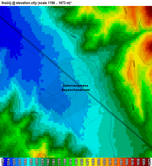
Below is the Elevation map of Ihsüüj, which displays elevation range with different colors. Scale of the first map is from 1196 to 1673 m (3924 to 5489 ft) with average elevation of 1328 meters (=4357 ft) [note 1]
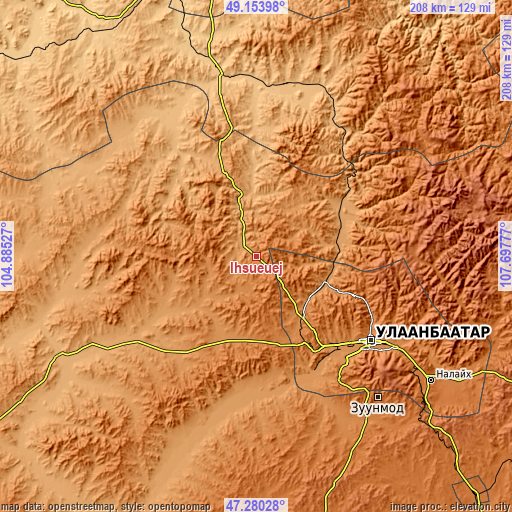
These maps also provides idea of topography and contour of this city, they are displayed at different zoom levels. More info about maps, scale and edge coordinates you can find below images.
| \ | Map #1 | Topo.Map |
| Scale [m] | 1196..1673 m | × |
| Scale [ft] | 3924..5489 ft | × |
| Average | 1328 m = 4357 ft | × |
| Width | 6.51 km = 4 mi | 208.3 km = 129.4 mi |
| Height | 6.51 km = 4 mi | 208.3 km = 129.4 mi |
| ↑Max Latitude | 48.254968° | 49.15398° |
| Latitude at center | 48.2257° | 48.2257° |
| ↓Min Latitude | 48.196415° | 47.28028° |
| ← Min Longitude | 106.247575° | 104.88527° |
| Longitude center | 106.29152° | 106.29152° |
| →Max Longitude | 106.335465° | 107.69777° |
Nearby cities:
Cities around Ihsüüj sort by population:
• Ulan Bator elevation 1284 m
56.4 km,  128°
128°
• Dzüünharaa 867 m
70.7 km,  9°
9°
• Javhlant 864 m
69.6 km,  337°
337°
• Ar-Asgat 1169 m
65.3 km,  273°
273°
• Ulaanhad 1091 m
62.8 km,  240°
240°
• Altanbulag 1210 m
59 km,  172°
172°
• Dzüünkharaa 1123 m
55.8 km,  35°
35°
• Jargalant 991 m
45.3 km,  316°
316°
• Argalant 1225 m
43.1 km,  222°
222°
• Mandal 1127 m
36.9 km,  64°
64°
• Dund-Urt 1191 m
34.5 km,  232°
232°
• Bornuur 1007 m
26.9 km,  356°
356°
Multilingual:
 En español:
Ihsüüj elevación 1269 m.
 En France:
Ihsüüj élévation 1269 m.


Sources and notes:
- [note 1] Map square and city borders are not equal. Map elevation data is calculated only from area inside that square.
- [src 1] Elevation data from geonames database provided with same terms of usage.
- [src 2] The elevation map of Ihsüüj is generated using elevation data from NASA's 3 arcsec (90m) resolution SRTM data.
- [src 3] Base (background) map © OpenStreetMap contributors tiles are generated by Geofabrik and OpenTopoMap.
Copyright & License:
This Ihsüüj Elevation Map is licensed under CC BY-SA. You may reuse any part from this page, if you give a proper credit by linking to this URL:
 More info on terms of use page.