Tavin elevation
Tavin (Middle Govĭ), Mongolia elevation is 1482 meters and Tavin elevation in feet is 4862 ft above sea level [src 1]. Tavin is a seat of a second-order administrative division (feature code) with elevation that is 69 meters (226 ft) bigger than average city elevation in Mongolia.
Below is the Elevation map of Tavin, which displays elevation range with different colors. Scale of the first map is from 1431 to 1584 m (4695 to 5197 ft) with average elevation of 1483.5 meters (=4867 ft) [note 1]
These maps also provides idea of topography and contour of this city, they are displayed at different zoom levels. More info about maps, scale and edge coordinates you can find below images.
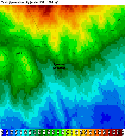
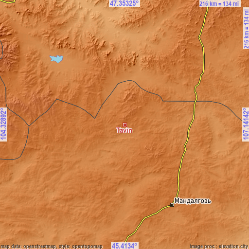
| \ | Map #1 | Topo.Map |
| Scale [m] | 1431..1584 m | × |
| Scale [ft] | 4695..5197 ft | × |
| Average | 1483.5 m = 4867 ft | × |
| Width | 6.74 km = 4.2 mi | 215.7 km = 134 mi |
| Height | 6.74 km = 4.2 mi | 215.7 km = 134 mi |
| ↑Max Latitude | 46.422242° | 47.35325° |
| Latitude at center | 46.39194° | 46.39194° |
| ↓Min Latitude | 46.361622° | 45.4134° |
| ← Min Longitude | 105.691225° | 104.32892° |
| Longitude center | 105.73517° | 105.73517° |
| →Max Longitude | 105.779115° | 107.14142° |
Nearby cities:
Cities around Tavin sort by population:
• Mandalgovi elevation 1424 m
81.3 km,  149°
149°
• Bayshint 1256 m
133.6 km,  328°
328°
• Rashaant 1219 m
126.6 km,  163°
163°
• Bumbat 1617 m
124.5 km,  275°
275°
• Dzogsool 1381 m
117.2 km,  67°
67°
• Tsagaan-Ovoo 1437 m
98.4 km,  179°
179°
• Hujirt 1588 m
91.1 km, 284°
• Tsant 1312 m
78.9 km,  107°
107°
• Bayantöhöm 1275 m
78.3 km,  318°
318°
• Sangiyn Dalay 1392 m
74.5 km,  235°
235°
• Bayanbaraat 1501 m
65.8 km,  36°
36°
• Amardalay 1400 m
57.4 km,  121°
121°
Multilingual:
 En español:
Tavin elevación 1482 m.
 En France:
Tavin élévation 1482 m.


Sources and notes:
- [note 1] Map square and city borders are not equal. Map elevation data is calculated only from area inside that square.
- [src 1] Elevation data from geonames database provided with same terms of usage.
- [src 2] The elevation map of Tavin is generated using elevation data from NASA's 3 arcsec (90m) resolution SRTM data.
- [src 3] Base (background) map © OpenStreetMap contributors tiles are generated by Geofabrik and OpenTopoMap.
Copyright & License:
This Tavin Elevation Map is licensed under CC BY-SA. You may reuse any part from this page, if you give a proper credit by linking to this URL:
 More info on terms of use page.