Hujirt elevation
Hujirt (Central Aimak), Mongolia elevation is 1588 meters and Hujirt elevation in feet is 5210 ft above sea level [src 1]. Hujirt is a seat of a second-order administrative division (feature code) with elevation that is 175 meters (574 ft) bigger than average city elevation in Mongolia.
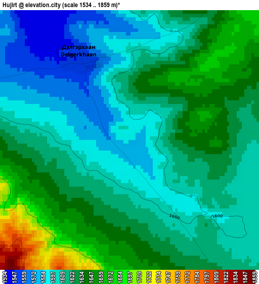
Below is the Elevation map of Hujirt, which displays elevation range with different colors. Scale of the first map is from 1534 to 1859 m (5033 to 6099 ft) with average elevation of 1619.2 meters (=5312 ft) [note 1]
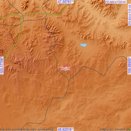
These maps also provides idea of topography and contour of this city, they are displayed at different zoom levels. More info about maps, scale and edge coordinates you can find below images.
| \ | Map #1 | Topo.Map |
| Scale [m] | 1534..1859 m | × |
| Scale [ft] | 5033..6099 ft | × |
| Average | 1619.2 m = 5312 ft | × |
| Width | 6.71 km = 4.2 mi | 214.9 km = 133.5 mi |
| Height | 6.71 km = 4.2 mi | 214.9 km = 133.5 mi |
| ↑Max Latitude | 46.630186° | 47.55761° |
| Latitude at center | 46.6° | 46.6° |
| ↓Min Latitude | 46.569797° | 45.62516° |
| ← Min Longitude | 104.539385° | 103.17708° |
| Longitude center | 104.58333° | 104.58333° |
| →Max Longitude | 104.627275° | 105.98958° |
Nearby cities:
Cities around Hujirt sort by population:
• Ulaanhudag elevation 1339 m
81.8 km,  355°
355°
• Shiree 1482 m
123.4 km,  227°
227°
• Sangiyn Dalay 1705 m
96.9 km,  273°
273°
• Ulaanshiveet 1308 m
94.4 km,  324°
324°
• Bayshint 1256 m
92.5 km,  11°
11°
• Tavin 1482 m
91.1 km,  104°
104°
• Mönhbulag 1797 m
83.1 km,  281°
281°
• Mayhan 1510 m
80.4 km, 225°
• Ongon 1491 m
74.3 km,  304°
304°
• Sangiyn Dalay 1392 m
71.4 km,  157°
157°
• Bayantöhöm 1275 m
50 km,  45°
45°
• Bumbat 1617 m
37.4 km,  252°
252°
Multilingual:
 En español:
Hujirt elevación 1588 m.
 En France:
Hujirt élévation 1588 m.


Sources and notes:
- [note 1] Map square and city borders are not equal. Map elevation data is calculated only from area inside that square.
- [src 1] Elevation data from geonames database provided with same terms of usage.
- [src 2] The elevation map of Hujirt is generated using elevation data from NASA's 3 arcsec (90m) resolution SRTM data.
- [src 3] Base (background) map © OpenStreetMap contributors tiles are generated by Geofabrik and OpenTopoMap.
Copyright & License:
This Hujirt Elevation Map is licensed under CC BY-SA. You may reuse any part from this page, if you give a proper credit by linking to this URL:
 More info on terms of use page.