Ulaanhudag elevation
Ulaanhudag (Central Aimak), Mongolia elevation is 1339 meters and Ulaanhudag elevation in feet is 4393 ft above sea level [src 1]. Ulaanhudag is a seat of a second-order administrative division (feature code) with elevation that is 74 meters (243 ft) smaller than average city elevation in Mongolia.
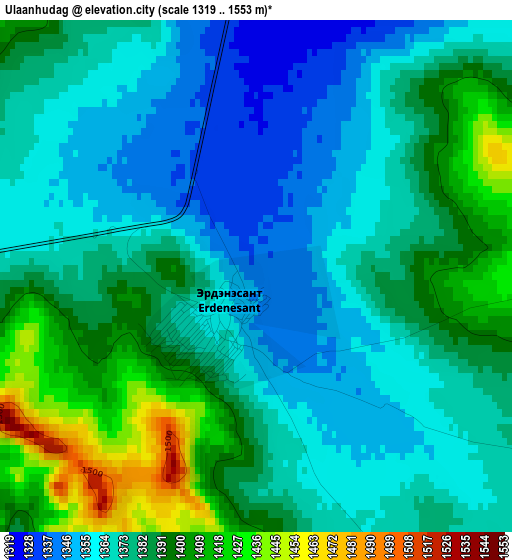
Below is the Elevation map of Ulaanhudag, which displays elevation range with different colors. Scale of the first map is from 1319 to 1553 m (4327 to 5095 ft) with average elevation of 1377.6 meters (=4520 ft) [note 1]
These maps also provides idea of topography and contour of this city, they are displayed at different zoom levels. More info about maps, scale and edge coordinates you can find below images.
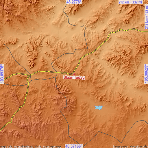
| \ | Map #1 | Topo.Map |
| Scale [m] | 1319..1553 m | × |
| Scale [ft] | 4327..5095 ft | × |
| Average | 1377.6 m = 4520 ft | × |
| Width | 6.62 km = 4.1 mi | 211.9 km = 131.7 mi |
| Height | 6.62 km = 4.1 mi | 211.9 km = 131.7 mi |
| ↑Max Latitude | 47.363105° | 48.2778° |
| Latitude at center | 47.33333° | 47.33333° |
| ↓Min Latitude | 47.303538° | 46.37166° |
| ← Min Longitude | 104.456055° | 103.09375° |
| Longitude center | 104.5° | 104.5° |
| →Max Longitude | 104.543945° | 105.90625° |
Nearby cities:
Cities around Ulaanhudag sort by population:
• Bat-Öldziyt elevation 1153 m
100.2 km,  11°
11°
• Mönhbulag 1797 m
98.8 km,  228°
228°
• Bumbat 1617 m
97.4 km,  197°
197°
• Hujirt 1588 m
81.8 km,  175°
175°
• Sujji 1009 m
81.7 km,  43°
43°
• Avdzaga 1137 m
81.1 km,  294°
294°
• Ongon 1491 m
66.7 km, 234°
• Dashinchilling 1016 m
66.6 km,  329°
329°
• Bayantöhöm 1275 m
62.3 km,  138°
138°
• Tsul-Ulaan 1035 m
55.6 km,  0°
0°
• Ulaanshiveet 1308 m
48.7 km,  264°
264°
• Bayshint 1256 m
25.6 km,  68°
68°
Multilingual:
 En español:
Ulaanhudag elevación 1339 m.
 En France:
Ulaanhudag élévation 1339 m.
 Auf Deutsch:
Ulaanhudag höhe über dem Meeresspiegel ist 1339 m.

Sources and notes:
- [note 1] Map square and city borders are not equal. Map elevation data is calculated only from area inside that square.
- [src 1] Elevation data from geonames database provided with same terms of usage.
- [src 2] The elevation map of Ulaanhudag is generated using elevation data from NASA's 3 arcsec (90m) resolution SRTM data.
- [src 3] Base (background) map © OpenStreetMap contributors tiles are generated by Geofabrik and OpenTopoMap.
Copyright & License:
This Ulaanhudag Elevation Map is licensed under CC BY-SA. You may reuse any part from this page, if you give a proper credit by linking to this URL:
 More info on terms of use page.