Mandalgovi elevation
Mandalgovi (Middle Govĭ), Mongolia elevation is 1424 meters and Mandalgovi elevation in feet is 4672 ft above sea level [src 1]. Mandalgovi is a seat of a first-order administrative division (feature code) with elevation that is 11 meters (36 ft) bigger than average city elevation in Mongolia.
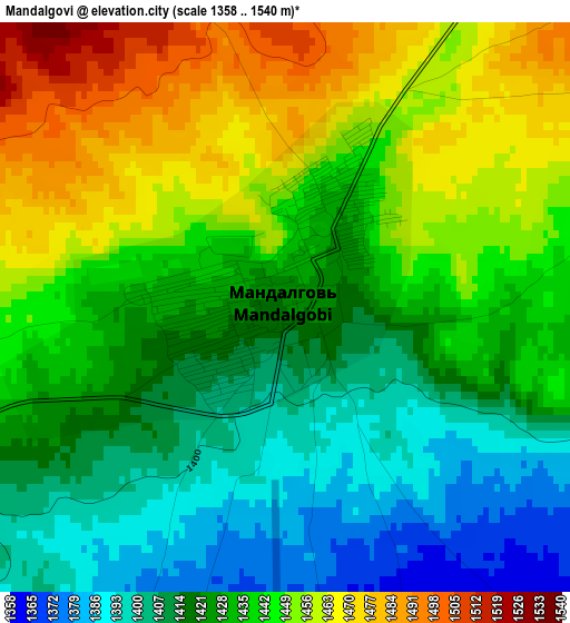
Below is the Elevation map of Mandalgovi, which displays elevation range with different colors. Scale of the first map is from 1358 to 1540 m (4455 to 5052 ft) with average elevation of 1433.2 meters (=4702 ft) [note 1]
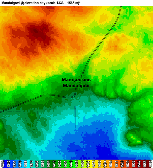
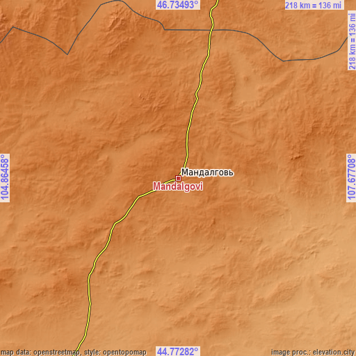
These maps also provides idea of topography and contour of this city, they are displayed at different zoom levels. More info about maps, scale and edge coordinates you can find below images.
| \ | Map #1 | Map #2 | Topo.Map |
| Scale [m] | 1358..1540 m | 1333..1565 m | × |
| Scale [ft] | 4455..5052 ft | 4373..5135 ft | × |
| Average | 1433.2 m = 4702 ft | 1438.3 m = 4719 ft | × |
| Width | 6.82 km = 4.2 mi | 13.64 km = 8.5 mi | 218.2 km = 135.6 mi |
| Height | 6.82 km = 4.2 mi | 13.64 km = 8.5 mi | 218.2 km = 135.6 mi |
| ↑Max Latitude | 45.793149° | 45.823782° | 46.73493° |
| Latitude at center | 45.7625° | 45.7625° | 45.7625° |
| ↓Min Latitude | 45.731834° | 45.701151° | 44.77282° |
| ← Min Longitude | 106.226885° | 106.182939° | 104.86458° |
| Longitude center | 106.27083° | 106.27083° | 106.27083° |
| →Max Longitude | 106.314775° | 106.358721° | 107.67708° |
Nearby cities:
Cities around Mandalgovi sort by population:
• Haraat elevation 1381 m
128.8 km,  55°
55°
• Hashaat 1463 m
128 km,  243°
243°
• Bayanbaraat 1501 m
122.8 km,  359°
359°
• Sangiyn Dalay 1392 m
106.4 km,  284°
284°
• Hajuu-Us 1457 m
99.6 km,  71°
71°
• Ulaanjirem 1250 m
96.4 km,  214°
214°
• Tavin 1482 m
81.3 km,  329°
329°
• Suugaant 1169 m
65.4 km,  113°
113°
• Tsant 1312 m
58.1 km,  36°
36°
• Rashaant 1219 m
51.7 km,  186°
186°
• Tsagaan-Ovoo 1437 m
49.1 km,  234°
234°
• Amardalay 1400 m
41.2 km,  11°
11°
Multilingual:
 En español:
Mandalgovi elevación 1424 m.
 En France:
Mandalgovi élévation 1424 m.
 Auf Deutsch:
Mandalgovi höhe über dem Meeresspiegel ist 1424 m.

Sources and notes:
- [note 1] Map square and city borders are not equal. Map elevation data is calculated only from area inside that square.
- [src 1] Elevation data from geonames database provided with same terms of usage.
- [src 2] The elevation map of Mandalgovi is generated using elevation data from NASA's 3 arcsec (90m) resolution SRTM data.
- [src 3] Base (background) map © OpenStreetMap contributors tiles are generated by Geofabrik and OpenTopoMap.
Copyright & License:
This Mandalgovi Elevation Map is licensed under CC BY-SA. You may reuse any part from this page, if you give a proper credit by linking to this URL:
 More info on terms of use page.