Hovd elevation
Hovd (Övörhangay), Mongolia elevation is 1525 meters and Hovd elevation in feet is 5003 ft above sea level [src 1]. Hovd is a populated place (feature code) with elevation that is 112 meters (367 ft) bigger than average city elevation in Mongolia.
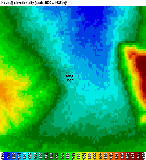
Below is the Elevation map of Hovd, which displays elevation range with different colors. Scale of the first map is from 1500 to 1635 m (4921 to 5364 ft) with average elevation of 1541.4 meters (=5057 ft) [note 1]
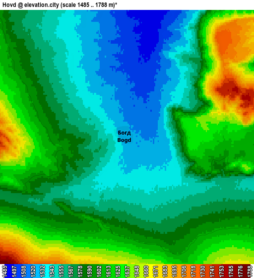
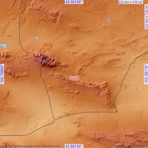
These maps also provides idea of topography and contour of this city, they are displayed at different zoom levels. More info about maps, scale and edge coordinates you can find below images.
| \ | Map #1 | Map #2 | Topo.Map |
| Scale [m] | 1500..1635 m | 1485..1788 m | × |
| Scale [ft] | 4921..5364 ft | 4872..5866 ft | × |
| Average | 1541.4 m = 5057 ft | 1583.9 m = 5197 ft | × |
| Width | 6.95 km = 4.3 mi | 13.9 km = 8.6 mi | 222.4 km = 138.2 mi |
| Height | 6.95 km = 4.3 mi | 13.9 km = 8.6 mi | 222.4 km = 138.2 mi |
| ↑Max Latitude | 44.701484° | 44.732711° | 45.66169° |
| Latitude at center | 44.67024° | 44.67024° | 44.67024° |
| ↓Min Latitude | 44.638979° | 44.607702° | 43.66154° |
| ← Min Longitude | 102.130965° | 102.087019° | 100.76866° |
| Longitude center | 102.17491° | 102.17491° | 102.17491° |
| →Max Longitude | 102.218855° | 102.262801° | 103.58116° |
Nearby cities:
Cities around Hovd sort by population:
• Bodĭ elevation 1407 m
150.4 km,  303°
303°
• Sharhulsan 1076 m
148.3 km,  90°
90°
• Mardzad 1889 m
142.6 km,  356°
356°
• Örgön 1584 m
141.1 km,  272°
272°
• Bulgan 1296 m
126 km,  120°
120°
• Horiult 1287 m
125.5 km, 297°
• Saynshand 2031 m
120.6 km,  166°
166°
• Hoolt 1395 m
115 km,  33°
33°
• Hatansuudal 1345 m
107.5 km,  262°
262°
• Arguut 1478 m
90.2 km,  12°
12°
• Bayan Uula Sumu 1245 m
82.3 km,  312°
312°
• Hovd 1446 m
16.5 km, 91°
Multilingual:
 En español:
Hovd elevación 1525 m.
 En France:
Hovd élévation 1525 m.


Sources and notes:
- [note 1] Map square and city borders are not equal. Map elevation data is calculated only from area inside that square.
- [src 1] Elevation data from geonames database provided with same terms of usage.
- [src 2] The elevation map of Hovd is generated using elevation data from NASA's 3 arcsec (90m) resolution SRTM data.
- [src 3] Base (background) map © OpenStreetMap contributors tiles are generated by Geofabrik and OpenTopoMap.
Copyright & License:
This Hovd Elevation Map is licensed under CC BY-SA. You may reuse any part from this page, if you give a proper credit by linking to this URL:
 More info on terms of use page.