Sharhulsan elevation
Sharhulsan (Ömnögovĭ), Mongolia elevation is 1076 meters and Sharhulsan elevation in feet is 3530 ft above sea level [src 1]. Sharhulsan is a seat of a second-order administrative division (feature code) with elevation that is 337 meters (1106 ft) smaller than average city elevation in Mongolia.
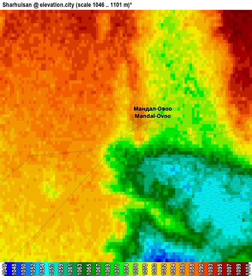
Below is the Elevation map of Sharhulsan, which displays elevation range with different colors. Scale of the first map is from 1046 to 1101 m (3432 to 3612 ft) with average elevation of 1078.8 meters (=3539 ft) [note 1]
These maps also provides idea of topography and contour of this city, they are displayed at different zoom levels. More info about maps, scale and edge coordinates you can find below images.
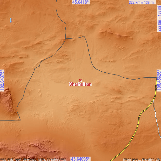
| \ | Map #1 | Topo.Map |
| Scale [m] | 1046..1101 m | × |
| Scale [ft] | 3432..3612 ft | × |
| Average | 1078.8 m = 3539 ft | × |
| Width | 6.95 km = 4.3 mi | 222.5 km = 138.3 mi |
| Height | 6.95 km = 4.3 mi | 222.5 km = 138.3 mi |
| ↑Max Latitude | 44.681255° | 45.6418° |
| Latitude at center | 44.65° | 44.65° |
| ↓Min Latitude | 44.618728° | 43.64095° |
| ← Min Longitude | 104.006055° | 102.64375° |
| Longitude center | 104.05° | 104.05° |
| →Max Longitude | 104.093945° | 105.45625° |
Nearby cities:
Cities around Sharhulsan sort by population:
• Hovd elevation 1525 m
148.3 km,  270°
270°
• Dalandzadgad 1470 m
123.7 km,  165°
165°
• Shiree 1482 m
142.8 km,  339°
339°
• Dalay 1563 m
138.3 km,  198°
198°
• Hovd 1446 m
131.8 km, 270°
• Hoolt 1395 m
129.1 km,  319°
319°
• Ulaanjirem 1250 m
127.6 km,  69°
69°
• Doloon 1297 m
103.8 km,  103°
103°
• Ögöömör 1517 m
102.3 km,  160°
160°
• Ongi 1309 m
89.7 km,  352°
352°
• Hashaat 1463 m
88.8 km,  42°
42°
• Bulgan 1296 m
73.5 km,  213°
213°
Multilingual:
 En español:
Sharhulsan elevación 1076 m.
 En France:
Sharhulsan élévation 1076 m.
 Auf Deutsch:
Sharhulsan höhe über dem Meeresspiegel ist 1076 m.

Sources and notes:
- [note 1] Map square and city borders are not equal. Map elevation data is calculated only from area inside that square.
- [src 1] Elevation data from geonames database provided with same terms of usage.
- [src 2] The elevation map of Sharhulsan is generated using elevation data from NASA's 3 arcsec (90m) resolution SRTM data.
- [src 3] Base (background) map © OpenStreetMap contributors tiles are generated by Geofabrik and OpenTopoMap.
Copyright & License:
This Sharhulsan Elevation Map is licensed under CC BY-SA. You may reuse any part from this page, if you give a proper credit by linking to this URL:
 More info on terms of use page.