Örgön elevation
Örgön (Bayanhongor), Mongolia elevation is 1584 meters and Örgön elevation in feet is 5197 ft above sea level [src 1]. Örgön is a seat of a second-order administrative division (feature code) with elevation that is 171 meters (561 ft) bigger than average city elevation in Mongolia.
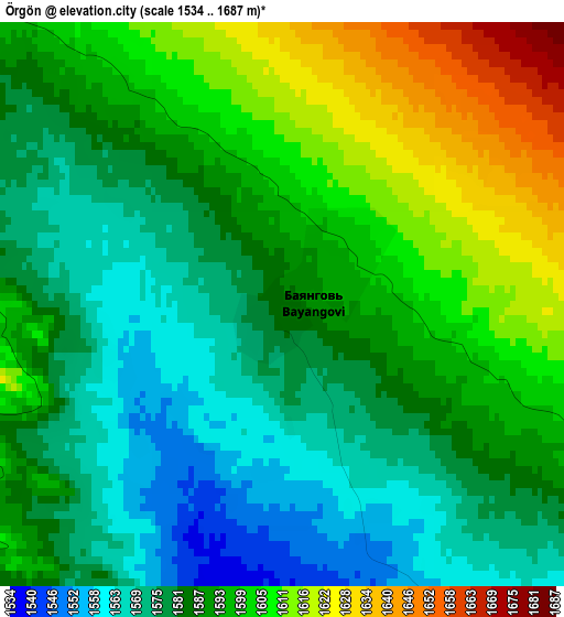
Below is the Elevation map of Örgön, which displays elevation range with different colors. Scale of the first map is from 1534 to 1687 m (5033 to 5535 ft) with average elevation of 1589.8 meters (=5216 ft) [note 1]
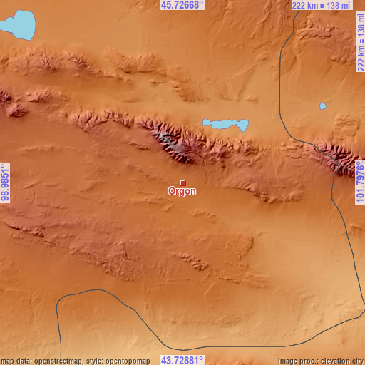
These maps also provides idea of topography and contour of this city, they are displayed at different zoom levels. More info about maps, scale and edge coordinates you can find below images.
| \ | Map #1 | Topo.Map |
| Scale [m] | 1534..1687 m | × |
| Scale [ft] | 5033..5535 ft | × |
| Average | 1589.8 m = 5216 ft | × |
| Width | 6.94 km = 4.3 mi | 222.1 km = 138 mi |
| Height | 6.94 km = 4.3 mi | 222.1 km = 138 mi |
| ↑Max Latitude | 44.767578° | 45.72668° |
| Latitude at center | 44.73637° | 44.73637° |
| ↓Min Latitude | 44.705145° | 43.72881° |
| ← Min Longitude | 100.347405° | 98.9851° |
| Longitude center | 100.39135° | 100.39135° |
| →Max Longitude | 100.435295° | 101.7976° |
Nearby cities:
Cities around Örgön sort by population:
• Hovd elevation 1525 m
141.1 km,  92°
92°
• Bayanhongor 1873 m
164.1 km,  8°
8°
• Tsagaan-Ovoo 1816 m
160 km,  31°
31°
• Hovd 1446 m
157.6 km, 92°
• Ulaan-Uul 1797 m
151.7 km, 12°
• Bulgan 2467 m
137.6 km,  272°
272°
• Bayansayr 1326 m
118.1 km,  320°
320°
• Bayan Uula Sumu 1245 m
92.7 km,  58°
58°
• Dzalaa 2262 m
91.8 km,  255°
255°
• Bodĭ 1407 m
76.4 km, 10°
• Horiult 1287 m
59.4 km, 29°
• Hatansuudal 1345 m
40.5 km,  121°
121°
Multilingual:
 En español:
Örgön elevación 1584 m.
 En France:
Örgön élévation 1584 m.


Sources and notes:
- [note 1] Map square and city borders are not equal. Map elevation data is calculated only from area inside that square.
- [src 1] Elevation data from geonames database provided with same terms of usage.
- [src 2] The elevation map of Örgön is generated using elevation data from NASA's 3 arcsec (90m) resolution SRTM data.
- [src 3] Base (background) map © OpenStreetMap contributors tiles are generated by Geofabrik and OpenTopoMap.
Copyright & License:
This Örgön Elevation Map is licensed under CC BY-SA. You may reuse any part from this page, if you give a proper credit by linking to this URL:
 More info on terms of use page.