Bayanhongor elevation
Bayanhongor, Mongolia elevation is 1873 meters and Bayanhongor elevation in feet is 6145 ft above sea level [src 1]. Bayanhongor is a seat of a first-order administrative division (feature code) with elevation that is 460 meters (1509 ft) bigger than average city elevation in Mongolia.
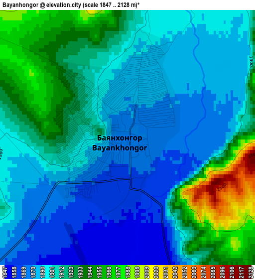
Below is the Elevation map of Bayanhongor, which displays elevation range with different colors. Scale of the first map is from 1847 to 2128 m (6060 to 6982 ft) with average elevation of 1907.9 meters (=6260 ft) [note 1]
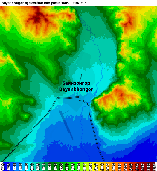
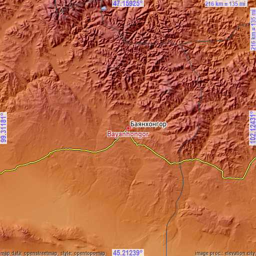
These maps also provides idea of topography and contour of this city, they are displayed at different zoom levels. More info about maps, scale and edge coordinates you can find below images.
| \ | Map #1 | Map #2 | Topo.Map |
| Scale [m] | 1847..2128 m | 1808..2197 m | × |
| Scale [ft] | 6060..6982 ft | 5932..7208 ft | × |
| Average | 1907.9 m = 6260 ft | 1932.7 m = 6341 ft | × |
| Width | 6.76 km = 4.2 mi | 13.53 km = 8.4 mi | 216.5 km = 134.5 mi |
| Height | 6.76 km = 4.2 mi | 13.53 km = 8.4 mi | 216.5 km = 134.5 mi |
| ↑Max Latitude | 46.224851° | 46.255245° | 47.15925° |
| Latitude at center | 46.19444° | 46.19444° | 46.19444° |
| ↓Min Latitude | 46.164012° | 46.133567° | 45.21239° |
| ← Min Longitude | 100.674115° | 100.630169° | 99.31181° |
| Longitude center | 100.71806° | 100.71806° | 100.71806° |
| →Max Longitude | 100.762005° | 100.805951° | 102.12431° |
Nearby cities:
Cities around Bayanhongor sort by population:
• Bayanhongor elevation 2202 m
74.1 km,  321°
321°
• Ongi 1991 m
123.9 km,  75°
75°
• Bayansayr 1326 m
122.2 km,  234°
234°
• Horiult 1287 m
110.6 km,  178°
178°
• Mardzad 1889 m
106.3 km,  104°
104°
• Bodĭ 1407 m
87.7 km,  187°
187°
• Dzadgay 2000 m
86.2 km,  271°
271°
• Bayanhoshuu 2125 m
71.6 km, 322°
• Tsagaan-Ovoo 1816 m
62.7 km,  114°
114°
• Erdenetsogt 2075 m
26.2 km,  17°
17°
• Höhbürd 1951 m
23.1 km,  296°
296°
• Ulaan-Uul 1797 m
16.1 km,  151°
151°
Multilingual:
 En español:
Bayanhongor elevación 1873 m.
 En France:
Bayanhongor élévation 1873 m.
 Auf Deutsch:
Bayanhongor höhe über dem Meeresspiegel ist 1873 m.

Sources and notes:
- [note 1] Map square and city borders are not equal. Map elevation data is calculated only from area inside that square.
- [src 1] Elevation data from geonames database provided with same terms of usage.
- [src 2] The elevation map of Bayanhongor is generated using elevation data from NASA's 3 arcsec (90m) resolution SRTM data.
- [src 3] Base (background) map © OpenStreetMap contributors tiles are generated by Geofabrik and OpenTopoMap.
Copyright & License:
This Bayanhongor Elevation Map is licensed under CC BY-SA. You may reuse any part from this page, if you give a proper credit by linking to this URL:
 More info on terms of use page.