Bayanhoshuu elevation
Bayanhoshuu (Bayanhongor), Mongolia elevation is 2125 meters and Bayanhoshuu elevation in feet is 6972 ft above sea level [src 1]. Bayanhoshuu is a seat of a second-order administrative division (feature code) with elevation that is 712 meters (2336 ft) bigger than average city elevation in Mongolia.
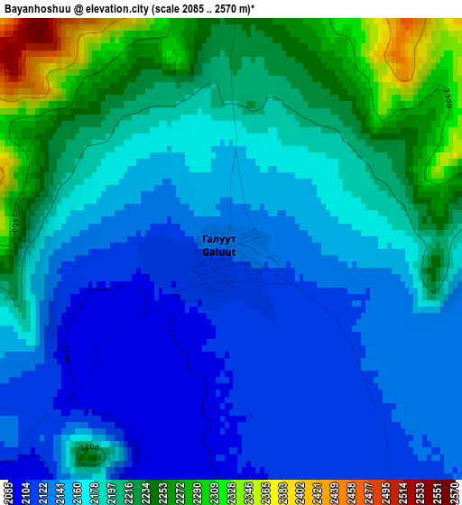
Below is the Elevation map of Bayanhoshuu, which displays elevation range with different colors. Scale of the first map is from 2085 to 2570 m (6841 to 8432 ft) with average elevation of 2178.3 meters (=7147 ft) [note 1]
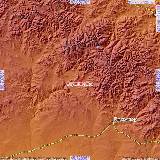
These maps also provides idea of topography and contour of this city, they are displayed at different zoom levels. More info about maps, scale and edge coordinates you can find below images.
| \ | Map #1 | Topo.Map |
| Scale [m] | 2085..2570 m | × |
| Scale [ft] | 6841..8432 ft | × |
| Average | 2178.3 m = 7147 ft | × |
| Width | 6.7 km = 4.2 mi | 214.5 km = 133.3 mi |
| Height | 6.7 km = 4.2 mi | 214.5 km = 133.3 mi |
| ↑Max Latitude | 46.732099° | 47.65776° |
| Latitude at center | 46.70197° | 46.70197° |
| ↓Min Latitude | 46.671824° | 45.72895° |
| ← Min Longitude | 100.099355° | 98.73705° |
| Longitude center | 100.1433° | 100.1433° |
| →Max Longitude | 100.187245° | 101.54955° |
Nearby cities:
Cities around Bayanhoshuu sort by population:
• Bayanhongor elevation 1873 m
71.6 km,  142°
142°
• Bayanhongor 2202 m
2.6 km,  308°
308°
• Buyant 1937 m
126.2 km,  241°
241°
• Dzaanhoshuu 1765 m
104.1 km,  32°
32°
• Bulagiyn Denj 1909 m
100.7 km,  47°
47°
• Jargalant 2033 m
92.6 km,  3°
3°
• Ulaan-Uul 1797 m
87.5 km, 143°
• Dzag 2013 m
78.9 km,  289°
289°
• Dzadgay 2000 m
68.7 km,  217°
217°
• Jargalant 2215 m
63.1 km,  322°
322°
• Erdenetsogt 2075 m
60.7 km,  121°
121°
• Höhbürd 1951 m
51.8 km,  153°
153°
Multilingual:
 En español:
Bayanhoshuu elevación 2125 m.
 En France:
Bayanhoshuu élévation 2125 m.
 Auf Deutsch:
Bayanhoshuu höhe über dem Meeresspiegel ist 2125 m.

Sources and notes:
- [note 1] Map square and city borders are not equal. Map elevation data is calculated only from area inside that square.
- [src 1] Elevation data from geonames database provided with same terms of usage.
- [src 2] The elevation map of Bayanhoshuu is generated using elevation data from NASA's 3 arcsec (90m) resolution SRTM data.
- [src 3] Base (background) map © OpenStreetMap contributors tiles are generated by Geofabrik and OpenTopoMap.
Copyright & License:
This Bayanhoshuu Elevation Map is licensed under CC BY-SA. You may reuse any part from this page, if you give a proper credit by linking to this URL:
 More info on terms of use page.