Dzag elevation
Dzag (Bayanhongor), Mongolia elevation is 2013 meters and Dzag elevation in feet is 6604 ft above sea level [src 1]. Dzag is a seat of a second-order administrative division (feature code) with elevation that is 600 meters (1969 ft) bigger than average city elevation in Mongolia.
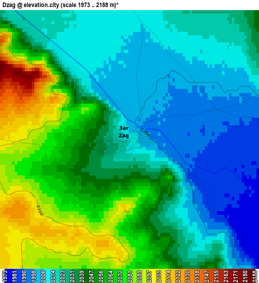
Below is the Elevation map of Dzag, which displays elevation range with different colors. Scale of the first map is from 1973 to 2188 m (6473 to 7178 ft) with average elevation of 2038 meters (=6686 ft) [note 1]
These maps also provides idea of topography and contour of this city, they are displayed at different zoom levels. More info about maps, scale and edge coordinates you can find below images.
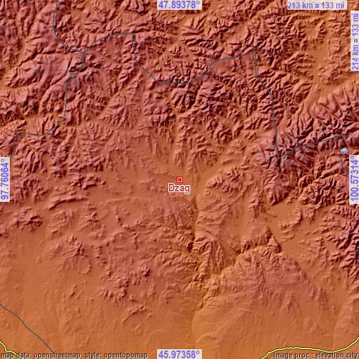
| \ | Map #1 | Topo.Map |
| Scale [m] | 1973..2188 m | × |
| Scale [ft] | 6473..7178 ft | × |
| Average | 2038 m = 6686 ft | × |
| Width | 6.67 km = 4.1 mi | 213.5 km = 132.7 mi |
| Height | 6.67 km = 4.1 mi | 213.5 km = 132.7 mi |
| ↑Max Latitude | 46.972285° | 47.89378° |
| Latitude at center | 46.94229° | 46.94229° |
| ↓Min Latitude | 46.912279° | 45.97358° |
| ← Min Longitude | 99.122945° | 97.76064° |
| Longitude center | 99.16689° | 99.16689° |
| →Max Longitude | 99.210835° | 100.57314° |
Nearby cities:
Cities around Dzag sort by population:
• Bayanhongor elevation 2202 m
76.5 km,  109°
109°
• Höhbürd 1951 m
122.1 km,  126°
126°
• Buyant 2155 m
121.9 km,  284°
284°
• Hunt 2130 m
105.2 km,  12°
12°
• Jargalant 2033 m
103 km,  50°
50°
• Buyant 1937 m
93.6 km,  202°
202°
• Delgermörön 2075 m
89.5 km,  228°
228°
• Dzadgay 2000 m
87.8 km,  157°
157°
• Bayanbulag 2256 m
83.2 km,  259°
259°
• Bayanhoshuu 2125 m
78.9 km, 109°
• Höviyn Am 2409 m
55.4 km,  305°
305°
• Jargalant 2215 m
42.2 km,  56°
56°
Multilingual:
 En español:
Dzag elevación 2013 m.
 En France:
Dzag élévation 2013 m.


Sources and notes:
- [note 1] Map square and city borders are not equal. Map elevation data is calculated only from area inside that square.
- [src 1] Elevation data from geonames database provided with same terms of usage.
- [src 2] The elevation map of Dzag is generated using elevation data from NASA's 3 arcsec (90m) resolution SRTM data.
- [src 3] Base (background) map © OpenStreetMap contributors tiles are generated by Geofabrik and OpenTopoMap.
Copyright & License:
This Dzag Elevation Map is licensed under CC BY-SA. You may reuse any part from this page, if you give a proper credit by linking to this URL:
 More info on terms of use page.